
Friday, December 31, 2010
Wednesday, December 29, 2010
Weather From 12/29 With Sarah Palin Hair
You know those annoying commercials for Bumpits!? I'm wearing one in my hair! Hahaha....They were $5.99 at Walgreens and I couldn't resist!
Lead in story was about how a North Carolina jeweler promised to refund all diamond purchases if it snowed 3" or more on X-Mas. It snowed 6" there!! We would have a lot of broke jewelers if they started making deals like that here in CT!
Lead in story was about how a North Carolina jeweler promised to refund all diamond purchases if it snowed 3" or more on X-Mas. It snowed 6" there!! We would have a lot of broke jewelers if they started making deals like that here in CT!
Tuesday, December 28, 2010
Monday, December 27, 2010
Christmas Blizzard
Although snowfall totals were not epic, this storm will really be remembered for the high winds!

- Greenwich: 60 mph
- Danbury: 60 mph
- Bridgeport: 60 mph
- New Haven: 60 mph
- New London: 68 mph
Dry air wrapped around the storm last night, choking snowfall rates in eastern and central Connecticut (6"-10"). Meanwhile the western part of the state got into some of the heavier snow bands (10"-18"). See the graphic below. The purple shaded area in NY is the 15"-30" band, where the heaviest snow fell. This is of course an average snowfall amount for various parts of the state.

- Wilton: 18"
- Greenwich: 17"
- Norwalk:16"
- Southbury: 11"
- Granby: 8.o"
- East Hartford: 14"
- Burlington: 11"
- Glastonbury: 10.2"
- Hartford: 6.5"-14"
Here are links to more snowfall totals and peak wind gusts. Make sure to check out the 20"-30" snowfall reports in NY/NJ. My Mom and sister were right inside the bullseye!
I Can Explain!
I'm recapping the weather forecast at the end of the FOX Midday News. My graphics are full screen.
Tim Paul, our floor director motions for me to lean into anchor Anthony DiLorenzo. Something is wrong with his microphone so mine will have to cover both of us.
Then we come back out to the couch shot...AWKWARD!!

And Anthony has no idea why I'm offering my chest to him.

I got an puzzled look and an awkward giggle. Last time I let him borrow my microphone! ;) Just another live TV moment!
Sunday, December 26, 2010
Saturday, December 25, 2010
Snowfall Totals
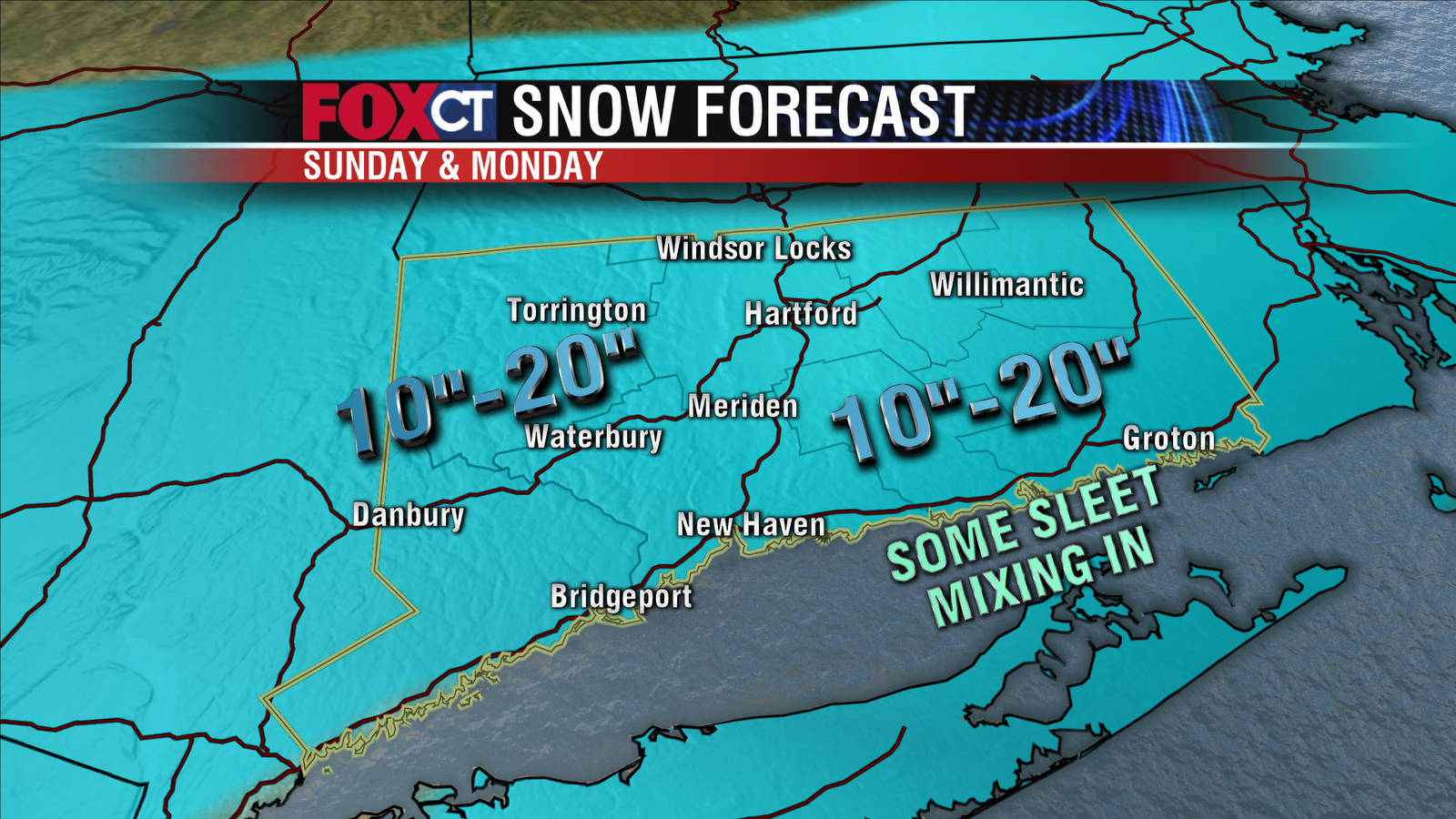
Most people will see a foot to a foot and a half of snow out of this storm! No matter how much snow falls, the wind is really a bigger issue because it will blow a lot of the snow around making it nearly impossible to see with blizzard conditions and zero visibility at times.
Southeastern Connecticut (New London) may see the lower end of the (10"-20") range with some sleet mixing in at times. The higher end of the totals will land where "mesoscale banding" occurs. These bands are nearly impossible to predict and are usually a few miles wide. Very heavy snow will occur in the bands, with thunder possible. Looks like they might set up in northwest CT but it's too early to tell.
Most of the snow that falls will be fluffy, powdery snow (the kind that is NOT good for making snowmen). But southeastern CT could see isolated power outages with a wetter, heavier snow.
Winter Storm Warnings

A Blizzard Warning is in effect for much of Southern CT from Sunday through Monday afternoon with snow accumulations over a foot in many areas and strong winds causing blowing and drifting of snow. Visibility will get down to zero at times making it dangerous if not impossible on the roads. Strong winds may also take down trees, power lines and Christmas decorations. Wind gusts could get up to 45-60 mph.
A Winter Storm Warning is in effect for the rest of the state from Sunday night into Monday. Snow accumulations will range from 10”-20”. Blowing and drifting snow will make for difficult and dangerous travel conditions. Snow will start off light Sunday morning getting steadier and heavier as the day progresses. The worst of the storm will be overhead Sunday night into early Monday with snowfall rates of 1”-3” per hour and whiteout conditions.
Here Comes The Snow! Poor Travel Conditions....
There is growing confidence that a moderate to major winter storm will impact Connecticut Sunday and Monday. The NWS has issued a Winter Storm Watch for late Sunday through Monday afternoon.
Timing
Sunday (during the day)
Some areas of snow around; activity will be mainly light. Snow will pick up in intensity around sunset.
Sunday night
Worst of the storm - this is when most of the snow will fall. Travel will be difficult or impossible during the storm’s peak. A strong wind will result in blowing and drifting of snow. Power outages are possible.
Monday
Snow will become less intense and taper to flurries and snow showers. If the storm were to stall, then a light snow could fall for most of the day. A strong wind will continue all day; resulting in additional blowing and drifting of the snow.
Friday, December 24, 2010
Storm Late Sunday - Monday
Dry and chilly for this Christmas Eve. Santa will have to hold on tight to your presents this evening with a breeze in place. Temperatures will drop into the teens and 20s tonight with frost possible by Christmas morning.
There will not be any problems Christmas Day weather wise with just an increase in clouds throughout the day. High temperatures will be near 30 degrees with a very light wind.
On Sunday a powerful Nor'Easter will take shape along the Carolina coast and then move north toward Cape Cod Sunday night into early Monday. The track of the storm will determine accumulations. The potential exists for blizzard conditions to develop across parts of New England by Sunday evening. Winds could gust upward to 60 mph causing considerable blowing and drifting of snow, in addition to scattered power outages. Snow fall amounts could approach a foot. The question is…will Connecticut get the direct hit OR fringe effects with just a few inches combined with blowing and drifting snow? Right now a direct hit is less likely. But it’s not out of the cards either. To be honest, this remains a low confidence forecast.
The storm will depart the region by late in the day on Monday and skies will clear out that night. Winds will remain strong and gusty.
Fair with moderating temperatures by Wednesday with day time highs approaching 40.
Stay with CTnow.com, Courant.com, Fox CT and WTIC AM 1080 for the latest on the snow storm for Sunday into Monday.
Friday, December 17, 2010
Saturday's Weather
High pressure will dominate our weather today with mostly sunny skies, chilly temperatures and light wind. Highs will climb into the low to mid 30s for most towns. Sorry snow lovers, Sunday’s ocean storm is not going to bring the mammoth snow amounts you were hoping for. In fact, the storm is likely a complete miss, heading out to sea without much fanfare. There’s still a possibility for fringe effects. The best chance snow showers will be in eastern Connecticut, closer to the storm’s path. But at this point you are in good shape for holiday shopping both days this weekend.
Snow Lovers...Don't Hold Your Breath
High pressure will dominate our weather tomorrow with mostly sunny skies, chilly temperatures and light wind. Highs will average in the 30s, lows in the teens.
Sorry snow lovers, Sunday’s ocean storm is not going to bring us the "snowpocalypse" you were hoping for. But there is still a lot of uncertainty regarding the storm’s track. The low pressure system could head out to sea, completely missing Connecticut. A track further east means fringe effects for the state with snow showers and the possibility for some light accumulation.
The best chance for snow will be in eastern CT, as this area is closer to the storm’s path with lesser effects in western CT – there will be a sharp cut-off to the precipitation shield.
We won’t be able to pin down potential snow amounts until Saturday, stay tuned!
Sunday Storm Thoughts
Still uncertainty in Sunday's forecast. I'm at the stage of ripping out my hair.
Every run of the computer model produces very large fluctuations in snowfall. The majority of the models this morning are keeping the storm out to sea on Sunday. But there are still some outliers that show near blizzard conditions. Probabilistic models have a 50% chance of 4" of snow on sunday. 50%?!!!! Really? We have the same odds forecasting if you flipped a coin!! (Insert meteorologist joke here.)
If I had to bet today...I would say it looks like the storm is not likely to be a direct hit. BUT that could certainly change with the afternoon model runs. I'm very excited to see if there are any trends. I'm working tonight so I get to obsess over the forecast.
Personally, here's the worst part. I am off this weekend. So there better not be a big storm without me at work!!!
Thursday, December 16, 2010
Manchester Torch Light Parade 2010!
Jennifer Lahmers and I were the guest judges at the event this year. If you don't already know Jenn....she's hilarious. You'll see what I mean when you watch George Colli's coverage of the event. I also think this is the first time George covered something other than death and destruction! Way to go George!
Tuesday, December 14, 2010
Friday, December 3, 2010
Thursday, December 2, 2010
Wind Gusts On Wednesday
Wind gusts on Wednesday were VERY impressive!!
Peak Wind Gusts (as of 7 PM EST Wed Dec 1)
Meriden: 58 mph
Bridgeport: 49 mph
Groton/New London: 49 mph
Waterbury/Oxford: 48 mph
Windsor Locks (BDL): 45 mph
Hartford: 45 mph
Now you know why there were 20,000 power outages! I hate power outages. If you can't watch TV, you should at least be able to open up the fridge to eat something to pass the time.
Wednesday, December 1, 2010
2010 Atlantic Hurricane Season Ends!
The season ended Tuesday! You can google a million detailed articles summarizing the season, but I am going to break it down even more!
This year's hurricane season was very active BUT the US got lucky!
Here are the stats:
- 19 named storms, 3rd highest number on record!
- 12 hurricanes, 2nd highest on record!
- 0 major hurricanes made landfall on US coasts (category 3 or higher)
This was the 5th year in a row that a major hurricane missed the US!
Monday, November 22, 2010
My Hair Is Awesome...But Not As Awesome as NBC's Amanda Raus.
 NBC's Amanda Raus wins the city league championship for the BEST HAIR IN CONNECTICUT! It is pretty nice.
Erika Arias scored the #2 spot. Silver, baby!
I'm....gulp....#3!????? Unacceptable!!! And J La is #4? Is that a joke? Her hair is flawless. I'm filing an appeal. You think Blumie will help take my case to the Supreme Court?
I can't stop laughing!
Maybe I'll actually give you a weather related blog post one day.
Sunday, November 21, 2010
Google Chrome & The Wilderness Downtown
My computers default browsers are Safari and Explorer. But I have always preferred Firefox. Now people are telling me to download yet ANOTHER browser?
Google Chrome.
Google claims its the fastest browser out there. We measure the speed of cars by how fast they can go from 0 to 60. In Internet land, google measures speed by things like: the number of searches per second or the number of tabs you can open per second.
Who cares. I'm usually on my couch eating buttered popcorn and watching TV while I search for crap I don't need to know. I'm in no rush to find out who is guest starring in next week's Glee episode.
I didn't care UNTIL a friend told me to check out a new kind of music video that you can only watch on Google Chrome. The Wilderness Downtown is an experimental interactive film created by Chris Milk in collaboration with Arcade Fire and Google. It was built using HTML5, Google Maps, an integrated drawing tool and it uses multiple browser windows as the user moves around the screen.
SOOOOOO COOOL! The geek in me can only imagine how long it took to code that video. Computer programmers have only scratched the surface when it comes to what HTML5 can do. But this video is a great preview.
Click here to download Google Chrome
Then watch the music video here!
Let me know what you think! Pretty cool stuff!
Saturday, November 20, 2010
Sunday, November 14, 2010
Wednesday, November 10, 2010
Monday, November 8, 2010
Snowfall Totals For Today
Many places saw their first snowflakes of the season last night into this morning. Others saw their first inch or two of accumulation! Eastern Connecticut was the bullseye in this storm with the greatest amounts in the higher elevations.
Hartford County:
Hartford County:
- Manchester: 1.0"
- Staffordville: 2.0"
- Coventry: 1.5"
- Tolland: 1.0"
Windham County:
- Moosup: 2.0"
- East Killingly: 1.5"
Fairfield County:
- Bridgeport: 0.4"
- Shelton: 0.3"
- Danbury: 0.2"
Middlesex County:
- Portland: 1.3"
- Killingworth: 0.5"
New Haven County:
- Madison: 1.0"
- New Haven: 0.5"
- Branford: 0.3"
New London County:
- Groton: 0.5"
Wednesday, November 3, 2010
Hard Freeze! (And Camera Phones....)
 Temperatures dropped below freezing last night all the way to the shoreline. A "hard freeze" like this marks the end to the growing season. So we will not see any freeze watches or warnings posted for the rest of the year.
By the way...I took this picture on my blackberry. Isn't it amazing how far camera phones have come? My first camera phone was so bad you couldn't even tell the gender of the blurry pixilated face that appeared on my caller I.D.
Sunday, October 31, 2010
Coldest Night This Season!
 The National Weather Service has issued a FREEZE WARNING for CT (2AM - 9AM Monday) because this evening is expected to be the coldest night of the season. BRRRRRRRRRRRRR!
A freeze warning is issued when temperatures are cold enough to kill outdoor plants.
I'm forecasting overnight low temperatures between 27-29 degrees inland, and 29-32 degrees along the shoreline.
IF the forecast is correct, this will "end the growing season". That means you will no longer see freeze watches or warnings because...plants are already dead.
Wednesday, October 13, 2010
Face The Music...In Business Class?
This is fun story about using music to teach people about teamwork and organization! But even more important, I sang on live TV. I guess you could say I'm officially "myself" on-air at this point. I never stop singing...whether you think it sounds good or not!
Tuesday, October 12, 2010
Monday, October 11, 2010
Sunday, October 10, 2010
Frosty Night
Overnight Lows:
Willimantic: 30
Windsor Locks: 36
Meriden: 32
Westfield: 32
New Haven: 39
Groton: 36
Bridgeport:41
Danbury: 33
Radiational cooling last night caused temperatures to plummet and jack frost payed a visit to many homes/gardens. BRRRRRRRRR!
Willimantic: 30
Windsor Locks: 36
Meriden: 32
Westfield: 32
New Haven: 39
Groton: 36
Bridgeport:41
Danbury: 33
Radiational cooling last night caused temperatures to plummet and jack frost payed a visit to many homes/gardens. BRRRRRRRRR!
Thursday, October 7, 2010
Monday, October 4, 2010
Monday's Forecast
This forecast is current for Monday
A slow moving storm will continue to spin up wet, breezy and cool conditions through Wednesday. Skies will remain cloudy today with showers or drizzle at times. Although it will not rain all day, keep the umbrella handy. Winds will howl at times, blowing out of the northeast at 5 to 15 mph with locally higher gusts. Tomorrow the storm will strengthen causing rain to become more steady and heavy. After a lingering shower early Thursday, clearing is expected. The end of the week looks great!
A slow moving storm will continue to spin up wet, breezy and cool conditions through Wednesday. Skies will remain cloudy today with showers or drizzle at times. Although it will not rain all day, keep the umbrella handy. Winds will howl at times, blowing out of the northeast at 5 to 15 mph with locally higher gusts. Tomorrow the storm will strengthen causing rain to become more steady and heavy. After a lingering shower early Thursday, clearing is expected. The end of the week looks great!
Holy Hail!
A few storms developed this afternoon with some cold air moving into the upper levels of the atmosphere. Some storms had lightning and high cloud tops that produced hail! Shelton Police reported hail 1.75" in diameter at 2:11 PM in Shelton! I haven't seen hail that big in any pics I have seen. But here are some other pics my lovely facebook friends sent in!
Pic taken by Robert Laskowski in Derby, sent from Steven Tootie

John Swingler, Shelton.
Joelene, Shelton 
Although there could be another isolated storm tonight with hail, I think most locations will just see a few leftover showers/drizzle. Periods of rain will continue right through Wednesday (maybe early Thursday).
Sunday, September 26, 2010
Wednesday, September 22, 2010
The Harvest Moon Illusion
 The Harvest Moon is magical…well not really. But if you go out tonight just after sunset, and are lucky enough to have a clear view of the horizon, you'll see the moon, pumpkin-colored, slowly rising in the east -- and, boy, does it look large.
It is, in fact, no larger in the sky than when it's overhead, but our minds fool us, perhaps because we have a reference point -- something on the horizon -- that we lack when it is high among the stars.
For example, when you see the moon in close proximity to a tree, your brain will miscalculate the distance to the moon, mentally bringing it closer (like the tree) and thus making it bigger. It seems so real, but this beautiful illusion is all in our minds.
Either that’s true, or the sky is falling! Chicken Little was right!
Tuesday, September 21, 2010
Wednesday, September 15, 2010
Tuesday, September 14, 2010
Sunday, September 12, 2010
Saturday, September 11, 2010
Freelance Meteorologist WPIX 11
 For those of you who are finding my blog after watching my second appearance on PIX11, WELCOME! My name is Rachel Frank, I am a meteorologist working full-time at FOX CT in Hartford. I am freelancing at PIX in my free time! Can I just say that it has always been my dream, since I was a little girl to “do the weather” in New York City? I was born and raised in Manhattan (Battery Park City) and I’m still a city girl at heart. I have worked at several tv-stations including WICU 12News in Erie, PA, WFMZ 69News in Allentown, PA and now FOX CT in Hartford. I am so happy to be back in the tri-state area! I go home to NYC every other weekend to see my friends and family that still live in the area.
Here’s the bio on my station’s website if you want
Here's a little more about me...
• First TV Appearance: Does college TV count? Hmmm…probably not. My first “real” TV appearance was on WICU 12News in Erie, Pennsylvania. I did the weather and I was so nervous I could barely breathe!
• Memorable Weather: Covering lake effect snow in Erie was interesting. The wind changes direction and suddenly there is 6 inches of snow on the ground. Also, I will never forget my first 3-hour non-stop tornado coverage. That was quite a challenge! It happened July 21st for the tornado in Bristol, CT.
• Favorite TV Program: It was LOST until the show ended and endlessly disappointed me. Right now my favorite shows are True Blood, Dexter, Entourage and The Real Housewives of New Jersey. Yeah, I like trash TV.
• First News Story: I reported on shopping carts being stolen from a Meadville, PA super market. I was so proud.
• Why I'm A Meteorologist: I am fascinated with the weather and I love to share my love and knowledge with anyone who’s willing to watch . I like to think I provide a little more info than your standard weather.com forecast. All that AND I loved the movie Twister. I'm not afraid to admit it.
• Alma Mater: Penn State University. I have a B.S. in Meteorology with a Weather Forecasting and Communications option.
• Hometown: New York City, New York
• Height: 5' 3" , but in front of the green screen I'm 5'11 thanks to the magic of television
• Star Sign: Gemini
• Siblings: 1
• Kids: 0
• Hobbies: Biking, Cross Country Skiing, Scuba Diving, Eating, Weather
• Favorite Foods: My appetite knows no bounds. I will try anything and I love creative presentations.
• Favorite Sports Teams: Penn State Nittany Lions! I don’t watch anything else! My family and friends are split between the Mets and the Yankees.
• Favorite Musician: Depends on my mood. I love rock, electronic music, and pop…just no country
• Favorite Destination: Paris, Prague, Venice, anywhere tropical, don't make me pick.
More questions?
Email me at rfrank@ctnow.com
Friend me on Facebook
Follow me on Twitter
Wednesday, September 8, 2010
Tuesday, September 7, 2010
Friday, September 3, 2010
Earl's On Track, Weakening
Hurricane Earl has been downgraded to a Category 1 storm, as expected. He has already turned to the NE, sparing much of Massachusetts from hurricane force winds.
Earl is on track to pass 200 miles east of Connecticut Friday night with moderate rain and winds picking up this evening, especially for southeastern CT (Groton, New London, Stonington). Winds could gust to 40 mph. Inland, conditions will improve rapidly. Most parts of CT will see very little or no rain from Earl, especially in the NW. I actually think tomorrow will feature more wind than tonight!

The Latest Stats on Earl
- Wind Speed: 85 mph
- Direction: NNE 21 mph
- Location: 350 Mi SSW of Nantucket, MA
Earl is forecast to weaken but still remains a large hurricane. An increase in speed and a turn to the NE is expected in the next 12-24 hours.
Hurricane force winds extend 70 miles from the storm's eye. Tropical storm force winds extend 205 miles from the eye.
Tropical Storm Force Wind Speed Probabilities:
 Southeastern CT has a greater chance of tropical storm force winds with the orange shading(50-60%). The rest of the state has a lower chance (30-50%). With little or no chance of gusty winds in the NW under the green shading (10-30%)
Earl's Wind History:
For most of the state, this will not be a storm for the history books. You'll remember the names Bob and Gloria, but forget Earl.
Fringe Effects From Earl in Connecticut
Fringe impacts are expected in Connecticut. Some of the outer rain bands of Hurricane Earl will move through the area. The best chance for rain will be after noon through very early Saturday morning. Some of these rain bands could produce some downpours. No significant flooding is expected; however, localized street floodig could occur within areas of heavy rain. It should be noted that some areas, especially in western and central Connecticut, could see very little or no rain as these areas will be on the western edge of the system. Rainfall totals remain difficult to pinpoint; the interaction of Earl with an upper level trough will determine how the precipitation field evolves. Any rain we see will be beneficial given the dry conditions in recent months.
The wind will increase out of the east during Friday afternoon. It will shift to the northeast and north during Friday night. Gusts may reach 40 to 50 mph in eastern and southern CT Friday evening. The combination of wet ground, fully foliated trees and wind may lead to some downed trees or limbs. This, in turn, may result in some power outages. For the remainder of the state (including the Hartford area), the wind could be gusty at times tomorrow evening; however, no major issues due to wind are expected in these areas.
As with any tropical system, we still need to closely monitor the track. Any deviations to the expected path would result in changes to the outlook.
Waves will increase during the day Friday as Earl approaches. Waves may exceed 6 feet in Long Island Sound; wave heights will likely exceed 10 feet in the open water of the Atlantic Ocean. Boat owners should be sure that their boats are properly secured for a storm. Seas will become dangerous on Friday. No major coastal flooding is expected in Connecticut with this storm. Large waves and deadly rip currents are possible through much of the holiday weekend along ocean beaches.
There will be a gusty westerly wind following the storm on Saturday. The holiday weekend will feature cooler and drier conditions; more fitting for the approach of autumn later this month. No weekend plans should be cancelled locally as the weather will be fine.
People planning to travel to Cape Cod, Martha’s Vineyard or Nantucket for this weekend will need to reconsider. The storm will be gone by Saturday; however, the storm will leave damage behind. Also, ferry service may be disrupted into Saturday due to high seas. Travel to other parts of the northeast should be fine this weekend.
Thursday, September 2, 2010
Earl Forecast Maps
 Please see the blog post below for a forecast discussion. But I also wanted to show you some of the latest forecast maps.
The graphic on the left shows the probability of tropical storm force winds (39-73 mph). You can click on the graphic to enlarge it. The areas shaded in purple tell us where the winds will be the most intense. For CT, the western and central parts of the state are highlighted in yellow which is a 30-50% chance for tropical storm force winds. But in Southeastern CT there's a 50-60% chance. And the LI sound (for those with boats) is in the 50-70% range. So the greatest threat for strong winds are in southeastern CT and the LI Sound
 Although some areas south and east could see tropical storm force winds, hurricane strength winds are highly unlikely. The map to the right shows the probability of winds reaching hurricane strength (sustained 74 mph winds or higher). Most of the state has little or no chance of that. Southeastern CT falls within the 5-10% range. Again, you can click on the map if you want to enlarge it.
 The track of this storm takes the center 150 miles east of CT. Here's the forecast cone. The shoreline of CT is shaded in yellow to show the Tropical Storm Watch in effect. Cape Cod will be closer to the center of the storm so that's why the pink shading is there to indicate a Hurricane Watch. You may want to re-think your plans to the Cape this weekend.
Could this storm change it's track and surprise us? A big change isn't likely. The computer models have been surprisingly consistent. The graphic below is called a spaghetti plot (because the lines on the graphic look like spaghetti). Each line represents a computer model's forecast track for hurricane Earl. You can see every line showing the storm swing out to sea EAST of Connecticut which is a favorable track for us. Notice all the tracks take Earl out to sea. But some of those tracks take the storm much closer to the shoreline. A closer track would mean heavier rain and stronger winds.
Hurricane Earl Expected to Glance Connecticut Late Friday
Nuisance, yes. Downed power lines, in spots. Disastrous, no.
Situation Overview:
Hurricane Earl is forecast to pass about 150 miles southeast of Long Island Friday evening. The greatest local impacts from Earl are expected across eastern long island and potentially Southeastern Connecticut.
Storm Information:
At 6 AM the center of Hurricane Earl was located about 800 miles south of Long Island, NY. Earl is moving NNW at 18 mph with winds of 45 mph.
Watches/Warnings:
If you have a boat,a Tropical Storm Watch continues for the entire shoreline. When making decisions...do not focus on the exact forecast track. Impacts from a hurricane can be felt several hundred miles away.
Precautionary/Preparedness Actions:
For the shoreline, continue with your preparations and listen for possible warnings. Small crafts should return to port or seek safe harbor.
I’ll try and update you throughout the day.
Wednesday, September 1, 2010
Tropical Storm Watch Issued For CT
A Tropical Storm Watch has been issued for Connecticut, including Long Island Sound. Tropical Storm watches extend from New Jersey to eastern Massachusetts. Hurricane Watches are posted for Cape Cod, Martha’s Vineyard and Nantucket.
Hurricane Earl remains a major hurricane. Maximum sustained winds are at 135 mph; Earl is a category 4 on the Saffir-Simpson Scale.
The storm is located to the northeast of the Bahamas and is moving to the NW. The storm is 
It still appears that destructive winds will remain to our east; however, gusty winds could lead to downed limbs and power lines Friday and Friday night.
Boate
The storm will be gone in time for the holiday weekend. Cooler and drier weather dominate. It’ll remain windy following the storm on Saturday.
Travel plans to Cape Cod or the islands may need to be reconsidered for the weekend. The storm will be gone by Saturday; however, ferry service may be disrupted. Also, damage and power outages could be widespread in the hurricane watch zone.
Tuesday, August 31, 2010
Let's Talk About Hurricane Earl
 Almost all of the computer models show a storm passing EAST of Connecticut which is a more favorable track. At this time that means SOME rain, SOME wind, but no hurricane force winds. The map in the upper left shows a 10-30% chance of tropical storm force winds. However, high waves, dangerous rip currents and beach erosion are a realistic problem that we face NO MATTER the track the storm takes.
Here is one of the latest computer models--the 12Z GFS for Friday night around 8:00 P.M. Remember this is just one computer model. But there are no big outliers at this time. Meaning, most of the models are showing pretty similar scenarios.
 The box in the upper right shows rainfall. You can see the heaviest rain still offshore, but it's still not out of the question for a decent soaking, especially if the storm moves as little as 50 miles west. The box in the upper middle shows us where the center of the low pressure will be moving (offshore). The lines around the low pressure system are called isobars or lines of equal pressure. When those lines are close together it shows a big difference in pressure. And winds are driven by differences in pressure. Tight lines=VERY WINDY!
The bottom right shows accumulated rainfall which is tough to rely on at this point. But a soaking is not out of the question.
I would be more concerned at this point for people who live on Cape Cod. They will be closer to the storm's center and some nasty winds and rain may become a reality for them.
 The cone in the picture to the right is called the "cone of uncertainty". The National Hurricane Center creates a cone around the forecast track to account for errors in forecasting or uncertainly in forecasting. That's why the cone gets bigger with time. But you will notice we are on the edge of the cone. So don't be alarmed if you see a map like this. It does not mean a hurricane is forecast to hit CT. But it means we need to watch this storm carefully because it's making forecasters at least a little nervous.
The bottom line: Nuisance? Probably. Should we start buying milk and eggs? No.
But stay tuned for updates. These storms are tricky!
Monday, August 30, 2010
Saturday, August 28, 2010
Watch Me Co Host The 4 PM Show!
This was my first time ever anchoring!! Only about 1/8 of my part of the show is on the teleprompter. All of the clips below are adlibbed! Watch me all next week on the FOXCT news at 4!
Wednesday, August 25, 2010
BIG NEWS!
Big news…I’ll be hosting the new 4 PM show this Friday and all of next week. A lot of the show is based on viewer comments/feedback! So if I post an interesting news story on facebook this Friday or next week, I’m going to need your responses to share live on the show!
What is the 4 PM show? Our newest hour-long weekly newscast started this Monday. It’s a very different show. You will NEVER find two stuffy anchors sitting at a desk going through the stories. Everyone gets involved in the newsroom. If there’s a breaking news story, Rachel Lutzker will approach the assignment desk and get the scoop live, for the first time along with the rest of the state. Courant reporters and other newsroom staffers who are not “trained in TV” will appear on a regular basis. And viewer feedback and comments are a regular part of the show.
Rachel handles the fun stuff, Brent Hardin covers hard news and Garett Argianas is on weather duty! You should watch the show and make suggestions. We are willing to hear them!
Again---I’ll be anchoring this Friday and all of next week. You can also find the show streaming live on CTNOW.com
Tuesday, August 24, 2010

Storm Totals From Sunday, Sunday Night, Monday
CONNECTICUT
...FAIRFIELD COUNTY...
DANBURY: 3.89
BRIDGEPORT: 2.59
BROOKFIELD : 2.52
BRIDGEPORT : 1.61
...MIDDLESEX COUNTY...
PORTLAND 1.49
...NEW HAVEN COUNTY...
MERIDEN : 2.88
NEW HAVEN/TWEED : 2.57
HAMDEN : 1.94
...NEW LONDON COUNTY...
OAKDALE : 2.57
GROTON/NEW LONDON : 0.92
...FAIRFIELD COUNTY...
DANBURY: 3.89
BRIDGEPORT: 2.59
BROOKFIELD : 2.52
BRIDGEPORT : 1.61
...MIDDLESEX COUNTY...
PORTLAND 1.49
...NEW HAVEN COUNTY...
MERIDEN : 2.88
NEW HAVEN/TWEED : 2.57
HAMDEN : 1.94
...NEW LONDON COUNTY...
OAKDALE : 2.57
GROTON/NEW LONDON : 0.92
Tuesday, August 17, 2010
BP BOAT SKIMS AROUND LAKE POCOTOPAUG?!

What the...? Just kidding! YES this is Lake Pocotopaug in East Hampton. BUT the boat was just a float participating in the 6th annual Friends of Lake Pocotopaug Dennis Griswold Showboat Parade. Staying with current events, the Spencer Funeral Home sponsored the likes of a BP skimmer pontoon boat. It was adorned with plastic brown water fowl, yellow haz-mat suits, and many cans of cold liquid dispersent.
How fun would it be to borrow that boat for a day and see how many people freak out? I would love to do a hidden camera show about that. Who's with me?!
To see this and more pics from the event, visit my buddy Al's website.
Perseid Light Show
As predicted below, last Friday was a fantastic day to view the perseid meteor shower. Check out this fantastic picture from my friend Al Chaniewski. 
He took took several pictures with a second exposure and compiled them in photoshop. The long streaks in the sky are debris from the comet Swift-Tuttle. You can see more of Al's pics here.

He took took several pictures with a second exposure and compiled them in photoshop. The long streaks in the sky are debris from the comet Swift-Tuttle. You can see more of Al's pics here.
Friday, August 13, 2010
Weekend Weather Discussion
Get ready for some fantastic weather this weekend! High pressure building in from Canada will keep the clouds away on Saturday with sunny skies and a dry comfortable air mass. Temperatures will top out in the upper 70s to low 80s with very low humidity. On Sunday the moisture in the air will increase a little, but it will remain pleasant outside with partly to mostly sunny skies. The humidity really gets cranking on Monday and Tuesday with the chance for showers and storms as a cold front approaches.
~Rach
~Rach
Thursday, August 12, 2010
Cosmic Crumbs
 The perseid meteor shower peaks tonight in Connecticut. This year was SUPPOSED to be exceptionally good for viewing because the moon will set early in the evening (9:00 PM) leaving the sky dark for nature’s light show. GO FIGURE…it’s cloudy outside and we don’t expect the clouds to break until midday Friday.
The perseid meteor shower is really just debris from the comet Swift-Tuttle which has been orbiting the earth for centuries. As debris collides with the earth’s atmosphere at 133,200 mph, the debris heats up to 3,000 degrees Fahrenheit. The heat causes the long lived streaks you see in the sky that resemble a shooting star. On a good night you can see one meteor a minute.
So what now? Well on Friday night skies will be mainly clear. The peak viewing period will have passed…BUT if you’re persistent you will probably get to see some action. Just go to an area with little or no surrounding city lights and look up! The best time to see the perseids will be after midnight through the pre-dawn hours Saturday morning.
Good luck. I’ll be staring up at the sky too! If you get any good pictures, send them my way!
Subscribe to:
Posts (Atom)