
Sunday, September 26, 2010
Wednesday, September 22, 2010
The Harvest Moon Illusion
 The Harvest Moon is magical…well not really. But if you go out tonight just after sunset, and are lucky enough to have a clear view of the horizon, you'll see the moon, pumpkin-colored, slowly rising in the east -- and, boy, does it look large.
It is, in fact, no larger in the sky than when it's overhead, but our minds fool us, perhaps because we have a reference point -- something on the horizon -- that we lack when it is high among the stars.
For example, when you see the moon in close proximity to a tree, your brain will miscalculate the distance to the moon, mentally bringing it closer (like the tree) and thus making it bigger. It seems so real, but this beautiful illusion is all in our minds.
Either that’s true, or the sky is falling! Chicken Little was right!
Tuesday, September 21, 2010
Wednesday, September 15, 2010
Tuesday, September 14, 2010
Sunday, September 12, 2010
Saturday, September 11, 2010
Freelance Meteorologist WPIX 11
 For those of you who are finding my blog after watching my second appearance on PIX11, WELCOME! My name is Rachel Frank, I am a meteorologist working full-time at FOX CT in Hartford. I am freelancing at PIX in my free time! Can I just say that it has always been my dream, since I was a little girl to “do the weather” in New York City? I was born and raised in Manhattan (Battery Park City) and I’m still a city girl at heart. I have worked at several tv-stations including WICU 12News in Erie, PA, WFMZ 69News in Allentown, PA and now FOX CT in Hartford. I am so happy to be back in the tri-state area! I go home to NYC every other weekend to see my friends and family that still live in the area.
Here’s the bio on my station’s website if you want
Here's a little more about me...
• First TV Appearance: Does college TV count? Hmmm…probably not. My first “real” TV appearance was on WICU 12News in Erie, Pennsylvania. I did the weather and I was so nervous I could barely breathe!
• Memorable Weather: Covering lake effect snow in Erie was interesting. The wind changes direction and suddenly there is 6 inches of snow on the ground. Also, I will never forget my first 3-hour non-stop tornado coverage. That was quite a challenge! It happened July 21st for the tornado in Bristol, CT.
• Favorite TV Program: It was LOST until the show ended and endlessly disappointed me. Right now my favorite shows are True Blood, Dexter, Entourage and The Real Housewives of New Jersey. Yeah, I like trash TV.
• First News Story: I reported on shopping carts being stolen from a Meadville, PA super market. I was so proud.
• Why I'm A Meteorologist: I am fascinated with the weather and I love to share my love and knowledge with anyone who’s willing to watch . I like to think I provide a little more info than your standard weather.com forecast. All that AND I loved the movie Twister. I'm not afraid to admit it.
• Alma Mater: Penn State University. I have a B.S. in Meteorology with a Weather Forecasting and Communications option.
• Hometown: New York City, New York
• Height: 5' 3" , but in front of the green screen I'm 5'11 thanks to the magic of television
• Star Sign: Gemini
• Siblings: 1
• Kids: 0
• Hobbies: Biking, Cross Country Skiing, Scuba Diving, Eating, Weather
• Favorite Foods: My appetite knows no bounds. I will try anything and I love creative presentations.
• Favorite Sports Teams: Penn State Nittany Lions! I don’t watch anything else! My family and friends are split between the Mets and the Yankees.
• Favorite Musician: Depends on my mood. I love rock, electronic music, and pop…just no country
• Favorite Destination: Paris, Prague, Venice, anywhere tropical, don't make me pick.
More questions?
Email me at rfrank@ctnow.com
Friend me on Facebook
Follow me on Twitter
Wednesday, September 8, 2010
Tuesday, September 7, 2010
Friday, September 3, 2010
Earl's On Track, Weakening
Hurricane Earl has been downgraded to a Category 1 storm, as expected. He has already turned to the NE, sparing much of Massachusetts from hurricane force winds.
Earl is on track to pass 200 miles east of Connecticut Friday night with moderate rain and winds picking up this evening, especially for southeastern CT (Groton, New London, Stonington). Winds could gust to 40 mph. Inland, conditions will improve rapidly. Most parts of CT will see very little or no rain from Earl, especially in the NW. I actually think tomorrow will feature more wind than tonight!

The Latest Stats on Earl
- Wind Speed: 85 mph
- Direction: NNE 21 mph
- Location: 350 Mi SSW of Nantucket, MA
Earl is forecast to weaken but still remains a large hurricane. An increase in speed and a turn to the NE is expected in the next 12-24 hours.
Hurricane force winds extend 70 miles from the storm's eye. Tropical storm force winds extend 205 miles from the eye.
Tropical Storm Force Wind Speed Probabilities:
 Southeastern CT has a greater chance of tropical storm force winds with the orange shading(50-60%). The rest of the state has a lower chance (30-50%). With little or no chance of gusty winds in the NW under the green shading (10-30%)
Earl's Wind History:
For most of the state, this will not be a storm for the history books. You'll remember the names Bob and Gloria, but forget Earl.
Fringe Effects From Earl in Connecticut
The wind will increase out of the east during Friday afternoon. It will shift to the northeast and north during Friday night. Gusts may reach 40 to 50 mph in eastern and southern CT Friday evening. The combination of wet ground, fully foliated trees and wind may lead to some downed trees or limbs. This, in turn, may result in some power outages. For the remainder of the state (including the Hartford area), the wind could be gusty at times tomorrow evening; however, no major issues due to wind are expected in these areas.
As with any tropical system, we still need to closely monitor the track. Any deviations to the expected path would result in changes to the outlook.
Waves will increase during the day Friday as Earl approaches. Waves may exceed 6 feet in Long Island Sound; wave heights will likely exceed 10 feet in the open water of the Atlantic Ocean. Boat owners should be sure that their boats are properly secured for a storm. Seas will become dangerous on Friday. No major coastal flooding is expected in Connecticut with this storm. Large waves and deadly rip currents are possible through much of the holiday weekend along ocean beaches.
There will be a gusty westerly wind following the storm on Saturday. The holiday weekend will feature cooler and drier conditions; more fitting for the approach of autumn later this month. No weekend plans should be cancelled locally as the weather will be fine.
People planning to travel to Cape Cod, Martha’s Vineyard or Nantucket for this weekend will need to reconsider. The storm will be gone by Saturday; however, the storm will leave damage behind. Also, ferry service may be disrupted into Saturday due to high seas. Travel to other parts of the northeast should be fine this weekend.
Thursday, September 2, 2010
Earl Forecast Maps
 Please see the blog post below for a forecast discussion. But I also wanted to show you some of the latest forecast maps.
The graphic on the left shows the probability of tropical storm force winds (39-73 mph). You can click on the graphic to enlarge it. The areas shaded in purple tell us where the winds will be the most intense. For CT, the western and central parts of the state are highlighted in yellow which is a 30-50% chance for tropical storm force winds. But in Southeastern CT there's a 50-60% chance. And the LI sound (for those with boats) is in the 50-70% range. So the greatest threat for strong winds are in southeastern CT and the LI Sound
 Although some areas south and east could see tropical storm force winds, hurricane strength winds are highly unlikely. The map to the right shows the probability of winds reaching hurricane strength (sustained 74 mph winds or higher). Most of the state has little or no chance of that. Southeastern CT falls within the 5-10% range. Again, you can click on the map if you want to enlarge it.
 The track of this storm takes the center 150 miles east of CT. Here's the forecast cone. The shoreline of CT is shaded in yellow to show the Tropical Storm Watch in effect. Cape Cod will be closer to the center of the storm so that's why the pink shading is there to indicate a Hurricane Watch. You may want to re-think your plans to the Cape this weekend.
Could this storm change it's track and surprise us? A big change isn't likely. The computer models have been surprisingly consistent. The graphic below is called a spaghetti plot (because the lines on the graphic look like spaghetti). Each line represents a computer model's forecast track for hurricane Earl. You can see every line showing the storm swing out to sea EAST of Connecticut which is a favorable track for us. Notice all the tracks take Earl out to sea. But some of those tracks take the storm much closer to the shoreline. A closer track would mean heavier rain and stronger winds.
Hurricane Earl Expected to Glance Connecticut Late Friday
Situation Overview:
Hurricane Earl is forecast to pass about 150 miles southeast of Long Island Friday evening. The greatest local impacts from Earl are expected across eastern long island and potentially Southeastern Connecticut.
Storm Information:
At 6 AM the center of Hurricane Earl was located about 800 miles south of Long Island, NY. Earl is moving NNW at 18 mph with winds of 45 mph.
Watches/Warnings:
If you have a boat,a Tropical Storm Watch continues for the entire shoreline. When making decisions...do not focus on the exact forecast track. Impacts from a hurricane can be felt several hundred miles away.
Precautionary/Preparedness Actions:
For the shoreline, continue with your preparations and listen for possible warnings. Small crafts should return to port or seek safe harbor.
I’ll try and update you throughout the day.
Wednesday, September 1, 2010
Tropical Storm Watch Issued For CT
Hurricane Earl remains a major hurricane. Maximum sustained winds are at 135 mph; Earl is a category 4 on the Saffir-Simpson Scale.
The storm is located to the northeast of the Bahamas and is moving to the NW. The storm is 
It still appears that destructive winds will remain to our east; however, gusty winds could lead to downed limbs and power lines Friday and Friday night.
Boate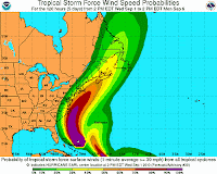
The storm will be gone in time for the holiday weekend. Cooler and drier weather dominate. It’ll remain windy following the storm on Saturday.
Travel plans to Cape Cod or the islands may need to be reconsidered for the weekend. The storm will be gone by Saturday; however, ferry service may be disrupted. Also, damage and power outages could be widespread in the hurricane watch zone.