
Thursday, February 28, 2013
Lamb-ish This Year
March typically comes in like a lion, out like a lamb. But I’m having trouble finding the lion in the forecast this
year! Temperatures will remain near or
even above average over the next several days.
A brief sprinkle or showers is possible on Friday with a mix of sun and
clouds. This weekend will be slightly
cooler. We continue to monitor the potential
for coastal storm next week. But as of right now, the storm looks to pass well
south of Connecticut with no big storms in sight!
Wednesday, February 27, 2013
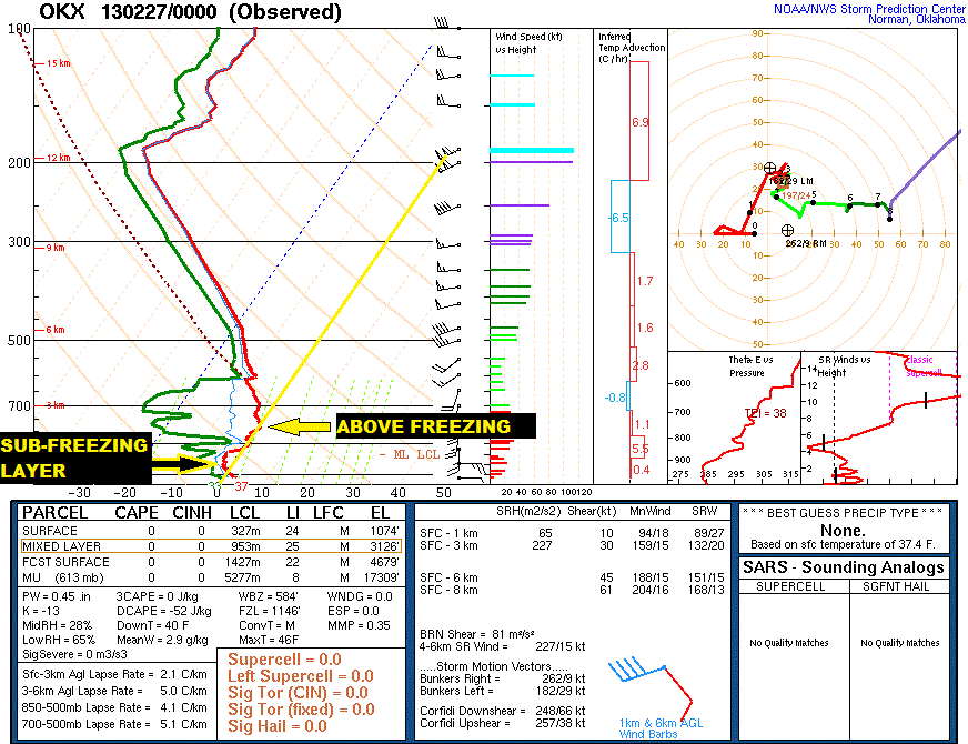
Impressive Storm Pulling Away
Rain, snow, sleet, damaging winds, coastal flooding and
lightning…This was an impressive storm!
Rain:
A new daily rainfall record was set on Wednesday at Windsor Locks. 1.27” of rain beats the previous record of 0.76” set back in 1971. No dice in Bridgeport. The current record of 1.6” set in 1971 still stands. Rainfall ranged from .75” – 1.5” statewide.
A new daily rainfall record was set on Wednesday at Windsor Locks. 1.27” of rain beats the previous record of 0.76” set back in 1971. No dice in Bridgeport. The current record of 1.6” set in 1971 still stands. Rainfall ranged from .75” – 1.5” statewide.
Wind:
Gusts topped 52-53 mph in both Bridgeport, Groton, New Haven and Norwalk.. Wind damage was reported in Milford where a telephone pole came crashing down. Isolated downed trees and power lines were also reported. Inland gusts were much less, ranging from 20-30 mph.
Gusts topped 52-53 mph in both Bridgeport, Groton, New Haven and Norwalk.. Wind damage was reported in Milford where a telephone pole came crashing down. Isolated downed trees and power lines were also reported. Inland gusts were much less, ranging from 20-30 mph.
Snowfall:
Only the high elevations of Hartford and Litchfield County had a slushy snow accumulation. 1”-3” was reported for Hartland, Norfolk, North Granby and Bakersville. Although other inland areas had a small sleet accumulation, most of it washed away by daybreak.
Only the high elevations of Hartford and Litchfield County had a slushy snow accumulation. 1”-3” was reported for Hartland, Norfolk, North Granby and Bakersville. Although other inland areas had a small sleet accumulation, most of it washed away by daybreak.
Looking Forward:
Tonight as the storm pulls away, watch for patchy fog and
drizzle. Winds continue to diminish, albeit slowly. Temps will drop into the
30s. Black ice could be an issue early
tomorrow on untreated sidewalks and roadways. Thursday is not nearly as
nasty. But you still need an
umbrella. Another disturbance will
rotate through keeping the sky mostly cloudy with a few scattered showers. High:
mid to upper 40s. As temps drop at night snow showers are possible. Watch for a slippery spots early Friday with
a small coating of snow in some inland areas. This weekend looks cooler (back
to the 30s) but more importantly dry!
Tuesday, February 26, 2013
Sleet!
White & Slushy Tonight, Wet & Windy Tomorrow
Snow and sleet early Wednesday will change over to rain
before daybreak. The morning commute will be wet and windy with gusts to 40
mph. Allow yourself some extra time getting to work. Some areas (especially in
northern Connecticut) may still be slippery and slushy from overnight snow. Periods
of rain continue throughout the day with around an inch of liquid. Rain will
taper to showers Wednesday night. Occasional rain and snow showers are possible
through Thursday. The least weekend looks dry!
Monday, February 25, 2013
Here We Go Again!
Both commutes will be dry on Tuesday. Clouds will thicken up
in the afternoon with temps climbing into the 40s again. A period of snow/mix will
break out late at night into Wednesday morning.
A coating to an inch or two of snow is possible by the morning drive
time. Slippery roads and school delays
are possible (especially inland) before precip changes over to rain. Rain will
continue off and on throughout the day. Occasional
rain and snow showers are possible all the way through Thursday.
Friday, February 22, 2013
Here We Go...

Storm Shifts Southeast, Messy But Not Bad!
 |
| Compare the Euro's precip forecast to the one in yesterday's post! Big difference! |
Temps climbed into the upper 30s and low 40s today. So where’s the cold? Good question! There isn’t any arctic air in place and it’s
not moving in. That’s why we will see a
little bit of everything this time around…snow, sleet, rain and then…more snow!
But temps will remain above freezing for almost the entire event. So any snow or sleet that falls should melt
on well traveled roads and highways. Sure,
roads will be slippery and slushy. But I’m
not going to tell you to halt travel altogether (like I did two weeks ago).
Tomorrow morning is quiet.
A few flurries might sneak in.
During the afternoon a more substantial period of snow overspreads the
state. A coating to 2” of accumulation
is possible before a switch over to rain from south to north. The rain will help wash away some or all of
the accumulation. The northwest and
northeast hills are the exception. Some
towns in the higher elevations will see temps around or just below the freezing
point. So any accumulation could stick
through the entire event.
Snow will be wet and heavy. Since we shouldn't get more than a few inches in most of the state, I don't expect power outages to be a big problem around here. But some isolated outages are possible.
 |
| Temps Saturday night stay above freezing except in the hills. |
Sunday morning the wind switches from east to north and cold
air is pulled in from the north leading to a change back over to snow. Snow
showers will continue Sunday morning. Some of the computer models end the storm
by lunch time. Others show lingering
snow and rain showers lasting into Sunday night. I’m inclined to agree with the latter
scenario at this time. An additional coating to 3” is possible.
If you add up all the snow that falls Saturday and Sunday
you get the map below. A coating to 2”
in southern Connecticut with 2”-5” in the northern part of the state. Of that range, the 4”-5” amounts are reserved
for the higher elevations of northwest and northeast Connecticut. Hartford will
end up with around 2”-3” total. But all the snow that falls will not
necessarily stick to the ground! As I mentioned, temps will stay above freezing
AND a period of rain will wash a lot of the snow away. So accumulations will be less than this in
most areas.

AND our active pattern continues with another wintry mix Wednesday
followed by an all snow event on Friday.
Let’s get through this one first before we get into details. Is it
spring yet?
If you made it this far, you're a real weather die hard. Your prize? Click this link for a silly video I made with my fiance! The funniest part? He came up with the script!
 |
| Position of the low Sunday morning ala the Euro |
 |
| Snowfall forecast based on a 10:1 snow to liquid ratio. This snow will be less than 10:1 (heavier & wet) |
Thursday, February 21, 2013
Finding The Rain/Snow Line Critical For Weekend Forecast
 |
| The 12z European Forecast Model (ECMWF) displaying Sunday morning. Notice a much weaker low compared to yesterday. 1000 mb compared to 992 mb (See yesterday's blog post). |
I debate over this with every storm…When do I release the
dreaded forecast snow map? Once you put a number out there, you can’t take it
back. People always remember the high
end of your forecast range too. If I show
6”-12” inland, 3”-6” for the shore, someone in Bridgeport will write me an
e-mail and ask me what happened to the foot of snow I was forecasting.
Usually I don’t release snowfall maps until I feel confident
that it will not need further tweaking (normally within 24-26 hours). But today, 48 hours from the storm I feel
compelled to tell you my thoughts. Other
meteorologists are putting out forecast maps earlier and earlier. And I don’t want my viewers to feel like I’m “holding
out” on them. I am competitive and I want my viewers to feel satisfied after
watching my forecast (without switching over to another station at 11).
That being said, I’m not as confident as I want to be with
my snowfall forecast. But I want to give
you my latest thoughts so you’re up to date on the latest trends, even if the
forecast might change down the line.
The massive winter storm that has been all over the news in
the middle of the Nation is NOT the storm heading our way. But as this storm dies it will lend its
energy to a new storm developing off the mid-Atlantic coast. This will be more of a typical Connecticut
winter storm with mainly snow in the hills, a mix in the interior and mainly
rain for the shoreline. FINALLY! All the storms so far this winter have had a bullseye
in the southern half of the state.
Snow/sleet will break out in the afternoon on Saturday (light
to start) before changing over to rain late afternoon into Saturday night. Rain
will then change back to a wintry mix after midnight into early Sunday morning
from northwest to southeast. The heaviest
snow is over by afternoon. But lingering snow showers are possible all the way
through Sunday night. Accumulations will hinge on when the changeover to snow
occurs and how heavy the snow is into Sunday morning. For those forecast
details, we need to know the storm’s track and the strength of the storm’s low.
But right now it doesn’t look like the storm will be strong
enough to overcome a mild easterly and southeasterly flow during the storm.
This means a period of rain or sleet will significantly cut down on snow accumulations. While this is still likely to be a messy
storm, it will not be a big snow producer for us. For areas north of the mass pike,
jackpot! All snow is expected to fall in
these areas and it’s just a matter of figuring out precip amounts.
I think the shoreline will get the lowest accumulations. The northwest and the northeast hills will get the most snow. This might even be an elevation event (valleys get less than hill tops). Right now I’m thinking 3”-6” for the northern half of the state with locally higher amounts in the hills and a coating to 3” for the southern half of the state. How confident is this forecast? Eh. The rain/snow line is so critical and a small change in the storm will greatly alter accumulations. But this seems like a good place to start and it just so happens to be in line with the European forecast model. Coincidence? No way. The Euro has been so consistent. I’m riding it until I get burned.
 |
| Preliminary Snowfall Forecast...subject to change! |
 |
| ECMWF snowfall based on 10:1 snow to liquid ratio |
 |
| ECMWF total precip. Notice western CT has lower precip amounts than eastern CT. That's why NE CT could get the most! |
 |
| Surface temps stay above freezing the entire event according to the Euro |
Wednesday, February 20, 2013
Weekend Worries...AGAIN!
For the third week in a row I’m tracking a winter storm for the weekend. Two weeks ago it was the blizzard (you don’t need me to remind you). Last week’s storm was a close call with near blizzard conditions for Cape Cod and the islands. This weekend will be storm number three and it comes with a whole new set of challenges.

What we know:
I’m highly confident of a winter storm this weekend. The timing would be Saturday afternoon through midday Sunday with the worst part of the storm hitting overnight Saturday into Sunday morning. Plowable snow is possible for most of the state. A rain/mix is most likely with an eventual change over to wet snow. That changeover will take longer along the shoreline leading to lower snowfall totals. BUT precip amounts will be high. The storm could produce 1-2” of liquid!
What we’re working on:
Unlike the last storm (all snow), the precipitation type is not as straight forward. A rain/snow line will likely set up somewhere in New England, maybe even OVER Connecticut. I mentioned above that the storm could produce up to 1”-2” of liquid.
If that were to fall entirely as snow, using a 10:1 snow to liquid ratio, that’s 10”-20”. Someone in New England is getting clobbered again. But snowfall totals like that are more likely in parts of Northern/Central Massachusets, Southern Vermont and southern New Hampshire. In Connecticut some of that liquid will fall as rain and sleet, cutting back on our snowfall totals. Finding the rain/snow line is key! This could end up being a storm with a huge range in snowfall totals with 1”-17” of snow from the coast to the hills.
Finding the rain/snow line will hinge on these factors:
Other concerns:
Because Connecticut will be near the rain/snow line, a heavy wet snow is a real possibility. This could cause outages as power lines and trees get coated in sludge.

I’m highly confident of a winter storm this weekend. The timing would be Saturday afternoon through midday Sunday with the worst part of the storm hitting overnight Saturday into Sunday morning. Plowable snow is possible for most of the state. A rain/mix is most likely with an eventual change over to wet snow. That changeover will take longer along the shoreline leading to lower snowfall totals. BUT precip amounts will be high. The storm could produce 1-2” of liquid!
What we’re working on:
Unlike the last storm (all snow), the precipitation type is not as straight forward. A rain/snow line will likely set up somewhere in New England, maybe even OVER Connecticut. I mentioned above that the storm could produce up to 1”-2” of liquid.
 |
| Precip totals by Sunday night from the European Forecast Model (ECMWF). Legend at the bottom is in inches. |
 |
| Total snowfall ECMWF (based on 10:1 ratio) |
Finding the rain/snow line will hinge on these factors:
- How quickly the storm strengthens. That will depend on the interaction between this storm and another one dying out over the great lakes.
- Surface temperature (obviously).
- The storm’s track can help determine precipitation type. Most major snow storms pass over what meteorologists call “the benchmark”. This is a spot over the ocean about 100 miles southeast of Montauk Point with the coordinates 40N, 70W. A storm passing south east of this sweet spot will generally produce less snow (too far away). A storm passing northwest of this point is more likely to bring a mix to Connecticut (more mild air, ocean influence). Obviously this isn’t the case 100% of the time as there are other variables. But it gives you the general idea. Right now the European forecast model has the storm tracking “inside” the benchmark, near/over Cape Cod. But that could change as we monitor the storm the next few days.
 |
| Sunday morning on the ECMWF. Notice how close the low's center comes to CT. |
Because Connecticut will be near the rain/snow line, a heavy wet snow is a real possibility. This could cause outages as power lines and trees get coated in sludge.
Tuesday, February 19, 2013
Cold & Snowy Days Ahead?

Monday, February 18, 2013
Really? Rain?
Hard to believe after a bitter cold start to the week, but
rain will be falling from the sky Tuesday afternoon! Southwesterly winds will
pump in milder air with temps returning to the 40s. Any morning sunshine
will fade behind increasing clouds as a cold front approaches.
Showers
will develop in the mid to late afternoon with rain around for the evening
commute. Rain could mix in with a touch of snow Tuesday night before the front
moves out. Colder, blustery conditions return Wednesday.
Yeah, yeah, yeah...there is a CHANCE for a storm on Saturday. One of our american models has latched onto the idea. AND the NAO is going negative which helps our chances for snow. But I'm not convinced yet. So much in the atmosphere can change between now and this weekend. AND the Euro has this whole mess staying to our south with another glancing blow. Don't worry about it for now. That's my job.
Bridgeport's Top Ten Snowiest Seasons On Record
So far this season, Bridgeport has accumulated 51.3" of snow (32.6" above average). If winter ended today, this season would be the 9th snowiest on record! But winter is far from over! By the way, at this time last year Bridgeport only had 11.6" of snow. Aww, how cute. A special thanks to Peter Wichrowski from the National Weather Service in NY for sending me this list.
Snowiest Seasons on Record for Bridgeport
Rank Value Ending Date
1 75.7
6/30/1996
2 64.0
6/30/2003
3 62.6
6/30/2011
4 61.6
6/30/1967
5 57.0
6/30/2005
6 55.3
6/30/2001
7 55.0
6/30/1994
8 52.7
6/30/1978
9 51.3
6/30/2013
10 49.0
6/30/2004
At 46.6", Windsor Locks is no where close to the top ten.
Friday, February 15, 2013
Quick Update On This Weekend's Snow
I'm forecasting a coating - 3" tonight into tomorrow midday. Another coating - 2" tomorrow night - Sunday morning. Total: 1"-4" statewide this weekend (highest eastern CT). Tomorrow night's forecast hinges on a powerful coastal storm and how far east it travels. Tough forecast but feeling better than yesterday!
Thursday, February 14, 2013
Saturday Scenarios
Friday afternoon will be milder than any day this week with temps in the mid to upper 40s. As I write this, Saturday is a low confidence forecast. Depending on which computer model you believe, Connecticut could get a few inches of snow, a half a foot of snow or none at all. Looking at the atmospheric set-up, I think a period of snow is most likely Saturday with one to three inches of accumulation (and a bigger coastal storm staying out to sea).
I'm going with the trusty Euro. When this model is consistent...it's far superior than our american models. ESPECIALLY when the GFS and NAM are flip flopping at every run!
The different models have different timing. But the Euro has snow showers starting early in the morning through late morning/early afternoon.
 |
| 12Z (morning) GFS...Time to dig out again! Parts of CT 6"+ |
 |
| 18Z (afternoon) GFS: Snow showers. Coating -1" Quite a change from one model run to the next! |
 |
| 12 Z ECMWF (Euro): 1"-3" 4 in spots. |
 |
| 18Z NAM: A MISS! Coating -1" |
The different models have different timing. But the Euro has snow showers starting early in the morning through late morning/early afternoon.
Wednesday, February 13, 2013

A Little Snow. So Little You Might Not Even Notice.
A quick moving storm will graze Connecticut tonight with a
little light snow. A coating to an inch
is possible. Whatever sticks will quickly
melt after the sun comes up. PHEW!!! I
have never been so worried about such a little storm before. But after the Blizzard of 2013 the stakes are
high! We’re running out of places to put
the snow.


The rest of Thursday is sunny and mild with temperatures in
the low 40s. Friday will be even
milder. That means we’ll continue to
slowly chip away at those stubborn piles of snow across the state. This weekend
turns cooler with temperatures returning to the 30s. But that big ocean storm some were worried
about earlier this week looks to head harmlessly out to sea. A few snow showers are possible Saturday afternoon.
Tonight: Light snow/flurries. Coating – 1” Low: 25-30.
Tomorrow: Mostly sunny. High: 40-45.
Friday: Partly cloudy. High: 43-48.
Saturday: Sun & clouds, chance snow showers. High: upper
30s
Sunday: Sunny. High: Near 30
Tuesday, February 12, 2013
Surprisingly Annoying Forecast
With temps in the 40s today we really started chipping away
at the snow pack. But any wet or slushy roadways could turn into ice
overnight as temperatures tumble into the 20s with clearing skies.
Black ice will be an issue during the Wednesday morning
drive. But temperatures will rebound in the afternoon (near 40 degrees)
contributing to more snow melt and slush. Clouds will increase throughout
the day as a quick moving coastal storm approaches. A period of snow is
possible later Wednesday night. HERE IS THE ANNOYING PART! The models have been back and forth with the idea of snow for Wednesday night. The American models have been flip flopping on snow amounts with the latest trend towards 1"-7" of snow in CT!!! The European model has consistently been showing a few flurries or a miss. Normally I would just go with the Euro (given it's impeccable track record). But there is a lot of lightning in the storm currently in the gulf coast states. And the one thing computer models have a tough handle on is convection (or strorms). So for now I'll go somewhere in the middle with this forecast (which I hate doing) and we'll see how things end up trending tomorrow. Again...this is annoying for such a small storm!!
Most of the state should get little or no
accumulation with a coating to an inch possible. Extreme southeastern
Connecticut could get up to two or three inches, but it certainly won’t create
any major problems.
Any snow should stop before sunrise on Valentine’s
Day. The rest of the day looks sunny and mild with high temperatures in
the low to mid 40s. Friday will be even milder with temps climbing into the
upper 40s. Then winter cold seeps back in over the weekend. COLD but not
stormy. Right now a big coastal storm developing over the weekend is
trending out to sea. We need to keep an eye on this storm just in case it
trends back west again. But for now the weekend looks decent!
Monday, February 11, 2013
Two Day Breather
Watch for slippery spots tonight as temperatures drop below
freezing. Dense fog will give way to
clearing by tomorrow morning. After a
chilly start to the day, milder air will take over in the afternoon with temps
returning to the 40s. Winds will pick up,
blowing out of the west at 10 to 20 mph. Wednesday will be equally mild and
quiet. But Wednesday evening could bring
the chance for more snow with a fast moving coastal storm. Notice I say “could”. There’s still a chance this storm trends out
to sea. For now I'm calling for a coating to an inch with 1"-2" in far southeastern New London County. My final forecast might be lower if the storm continues to trend farther south.

We’re also watching Saturday night into Sunday for another possible storm. But once again this storm is “iffy”. The euro has it missing. Enough said. ;)
Saturday, February 9, 2013
Blizzard of '78

Blizzard of 2013...Epic!!!!
We said this storm might be historic. But even I'm impressed. We called for 1'-2' with locally higher amounts. Well...1'-3' might be more accurate by tomorrow morning. This is a 100 year event. You may never live to see another storm like it!
Snow totals are smashing the Blizzard of '78!
It's 1:15 AM. I'm at work and there's no chance of getting home tonight. But that's OK. Who could sleep at a time like this?
 Remember the worst case scenario? The models that were predicting 2 feet with locally higher amounts? This is it.
I have no idea how anyone is going to measure how much snow is on the ground. The wind is whipping up drifts 5'-6' tall. No joke. They're taller than me outside the TV station in Hartford.
Gusts peaked early in the storm at 60 mph in Groton. Gusts to 40-45 were common in the rest of the state. As of 1:57 AM there are only 33,000 power outages. This is no October, 2011 in that department. GOOD! Because temps Saturday night will be dropping into the single digits!
I'd love to say something deep and profound about how this storm came together but I'm too busy watching the radar in awe! To be continued....
Snow totals are smashing the Blizzard of '78!
 |
| National Weather Service plotted snowfall reports (obviously some are outdated) |

I have no idea how anyone is going to measure how much snow is on the ground. The wind is whipping up drifts 5'-6' tall. No joke. They're taller than me outside the TV station in Hartford.
Gusts peaked early in the storm at 60 mph in Groton. Gusts to 40-45 were common in the rest of the state. As of 1:57 AM there are only 33,000 power outages. This is no October, 2011 in that department. GOOD! Because temps Saturday night will be dropping into the single digits!
I'd love to say something deep and profound about how this storm came together but I'm too busy watching the radar in awe! To be continued....
Thursday, February 7, 2013
Blizzard of 2013
ONE TO TWO FEET OF SNOW!
Sorry…after this winter, I felt like that sentence warranted caps
lock. If the forecast pans out, we’ll
call this storm the Blizzard of 2013 for years to come. Or we’ll just call it
Nemo. ;)
Timing: Friday morning – Saturday afternoon
We're in it for the long haul. Snow will start off light Friday morning. If you could stay off the roads all day, BONUS! But I know some of you still have to hit the roads. Get your stuff done in the morning. Conditions will deteriorate in the afternoon with snow becoming steady and heavier. Official blizzard conditions will not get underway until around or after sunset.
After sunset, be wherever you plan on spending the night. I wouldn’t be surprised if the Governor plans on closing the roads to non-essential vehicles. Snowfall rates Friday night into Saturday morning could get up to 1”-3” per hour. Add the heavy snow to gusty (perhaps damaging) winds and you have near white out conditions. Thundersnow is possible! Heavy snow continues through 6-8 am Saturday before conditions begin to improve. That doesn’t mean you’ll be able to drive to Saturday brunch at 10am. Plows will be playing catch up all morning long as snow tapers to a few leftover snow showers by afternoon.
Impacts:
- Some power outages are likely. This won’t be a repeat of the October nor’easter but scattered outages are possible, especially along the shoreline and in eastern Connecticut where winds will be the strongest.
- Snow drifts. Winds will blow the snow into piles that could get up to 4 feet high.
- Clean up. Sometimes after these big storms, it’s hard to find a place to put all the snow! Finding a parking spot could be challenging in the coming days.
- School/business cancellations and parking bans.
Accumulations:
One to two feet statewide. The two feet amounts are most likely in the northwest and northeast hills of Connecticut. The shoreline will be closer to the low end of that range with some mixing possible during the day on Friday. Mesoscale banding will set up within the storm. That means heavier bands of snow could bring locally higher amounts. Higher than two feet? Yeah, it’s possible if everything sets up perfectly.
One to two feet statewide. The two feet amounts are most likely in the northwest and northeast hills of Connecticut. The shoreline will be closer to the low end of that range with some mixing possible during the day on Friday. Mesoscale banding will set up within the storm. That means heavier bands of snow could bring locally higher amounts. Higher than two feet? Yeah, it’s possible if everything sets up perfectly.
Winds:
Sustained 20-30 mph inland with gusts to 40-50 mph.
Sustained 30-40 mph along the shoreline with gusts to 50-60 mph.
Sustained 20-30 mph inland with gusts to 40-50 mph.
Sustained 30-40 mph along the shoreline with gusts to 50-60 mph.
What is a blizzard?
At least three hours of: Sustained winds or frequent gusts to 30 mph combined with visibility of a quarter mile or less.
At least three hours of: Sustained winds or frequent gusts to 30 mph combined with visibility of a quarter mile or less.
Coastal Flooding:
During high tide on Friday night, the water will rise 3’-5’ higher than usual. Typical flood prone roads along the shoreline might become impassable for a while. Moderate coastal flooding is forecast for Bridgeport and Stamford with forecast water levels of 11-12 feet.
Type Of Snow:
95% of this storm will produce the light, fluffy, powdery stuff. But Friday morning the snow could start off wet and heavy, especially along the shoreline and in southern Connecticut.
Prep for power outages, stay off the roads…and you’re in
good shape! Enjoy your snow day. I remember how much fun I used to have
drinking hot chocolate and waiting for the madness to stop so I could go
sledding! Except…the “hills” in NYC were
only 3’.
Wednesday, February 6, 2013
Bombogenesis!
This is going to come across as lazy. But I've been forecasting with Bob Cox all day and his blog entry is word for word everything I would write. Check it out! http://weatherwithoutthehype.com/blog1/
I'll be preparing my forecast for the News at 10 & 11 with the free time I just created by stealing my coworkers stuff. ;)
I'll be preparing my forecast for the News at 10 & 11 with the free time I just created by stealing my coworkers stuff. ;)
Tuesday, February 5, 2013
Little Snow, Big Snow
Round two! One batch
of snow moved out this morning and now another one is moving in. Light snow will
continue off and on this evening. A
fresh coating of snow is possible. Watch
for slippery spots for the commute tomorrow.
 |
| This morning's European Computer Model. Sat AM |
Early snow and clouds will clear away, revealing partly to
mostly sunny skies. Temperatures will
moderate a bit in the afternoon with highs approaching 40 degrees in some
towns. Thursday is cooler but quiet. A significant storm is becoming
increasingly likely for Friday.
Two storms will be trekking across the country on Thursday.
The storm in the Great Lakes is weak but lacks moisture. The storm in the Gulf coast has tons of
moisture but no cold air. Combine the
two? And you have the ingredients for a
biggie. The resulting low will likely develop
off the Mid Atlantic coast Friday morning. If the European model is right, snow
starts to break out in the morning, becoming steadier and heavier during the
afternoon and evening. Winds will pick up, lowering visibility. Oh and accumulations? Don’t ask.
One computer model has us shoveling a foot or more by Saturday morning. The
potential is there. But there is still a
fudge factor. A shift in the storm’s
track of just 50 miles could mean the difference between a foot of snow and a
few inches. What if the storms don’t
phase? What if they take too long to phase? Plus, if the storm tracks closer to New England,
there could be some mixing along the Connecticut shore!
Here’s the take away.
Plowable snow is almost guaranteed at this point. BOTH commutes on
Friday will be impacted. And this could
be the biggest snow storm we have seen in two years if everything “phases” just
right. We’ll keep you posted!
Tonight: Light snow. A fresh coating -1”. Low: 20s
Tomorrow: Early snow, turning partly to mostly sunny, breezy, not as cold. High: 35-40
Tomorrow night: Mostly Clear. Low: teens
Thursday: Cooler, partly cloudy. High: Near 30
Friday: Light morning snow, becoming steadier and heavier. Windy. High: Near 30
Saturday: Snow ending pre-dawn. Mostly sunny. High: Near 30
Friday, February 1, 2013
Colder Tomorrow. Good Luck Phil!
A deep freeze has settled in. Saturday morning temperatures will begin in
the teens and twenties with a light breeze. The wind picks up in the afternoon
with clouds increasing throughout the day. Saturday night a storm will
intensify southeast of New England. Right now Connecticut appears to be on the
periphery of this system with some light snow showers Saturday night into
Sunday. A coating to an inch of snow is
possible with higher amounts for southeastern Rhode Island and Massachusetts. Sorry for the boring weather write up. It's Friday and I'm busy designing new weather graphics. It's for your own good.
Punxsutawney Phil Vs. the U.S. National Temperature 1988–2012
Phil's cute. But he's not taking my job.

FOR FUN...let's pretend above average temperatures in both February and March represents spring arriving early. OK...that's 11 out of the last 25 years. But out of those 11 years, Phil only predicted an early spring 4 times ('99, '97, '95, '90). Get it together man.
In 116 years of records, Phil saw...
His shadow: 100 times
No shadow: 16 times
Subscribe to:
Posts (Atom)