THANKS FOR VISITING!

I'm an Emmy Award Winning meteorologist at Fox 61 in Hartford. For the latest forecast updates (and fun stuff too, like food and family pics), please follow me on Facebook, twitter and instagram. I look forward to interacting with you there!

LIKE ME ON FACEBOOK!

Sunday, July 29, 2012

Humid All Week

I'm not even going to bother showing the Frizz Factor this week.  With moderate humidity sticking around all the way through NEXT weekend, just throw the hair up in a pony tail and call it a day.

Scattered downpours and flash flooding put a damper on some weekend plans. Check out these rainfall totals over the last 24 hours!  Winsted is reporting 3.3” of rain, 2.75” in Newington and 2.13” in Brookfield. People who were complaining about the recent dry weather are now turning into prunes.


But the next couple of days look better!  High pressure will chase the clouds away tomorrow providing partly to mostly sunny skies.  An isolated afternoon shower cannot be ruled out, but most towns will stay dry.  More clouds filter in Tuesday.  There’s a better chance for pop up afternoon showers on Wednesday and Thursday. Temperatures will remain near or below average the next few days before warming up late week. Moderate humidity is here to stay!

Friday, July 27, 2012

Nasty Storms For Southwestern CT


All the blue dots on the map above represent wind damage from yesterday's storms. Notice how the northern extent of the storm damage stops in southwestern CT.  This is where the storms came to die. Boy, did we dodge a bullet!

The storms caused some wind damage in Litchfield and Fairfield Counties with wind gusts up to 52 mph in Bridgeport. Then then storms significantly weakened moving into Waterbury and New Haven.

A southwest wind certainly didn't help with the storms ingesting cooler, more stable marine air.  But I think the late arrival of the sun made a big difference too.  Areas that broke into the warm sector sooner had better instability. There were a few other timing/lapse rate issues too.  Stuff that you can't predict until the event is unfolding right in front of you.

Several key ingredients were there for nasty storms so looking back I wouldn't change anything about my forecast.  But I know people plan their day after watching me.  So I always feel bad when things don't go according to plan.  I'm not a hyper.  But I think it's better to be safe than sorry.

In the mean time, crank up the A.C. and enjoy the fact that you have power tonight!

Wednesday, July 25, 2012

BIG Severe Weather Threat

With sunshine, low humidity and a gentle breeze, you would never guess that a significant severe weather threat is looming for tomorrow.

The Storm Prediction Center (SPC) in Norman Oklahoma has the state in a “moderate” risk of severe weather.  Such a high risk on a “Day 2” forecast is rare for us here in Connecticut.  The greatest threat tomorrow is damaging winds and large hail.  But flash flooding is also possible and there is an elevated risk for tornadoes too.

There will be two rounds of storms tomorrow.  The first round will come from a dying complex of thunderstorms that can currently be found in the Great Lakes.  This cluster of storms will ride along a warm front through New York and arrive in Connecticut tomorrow morning.  Heavy rain, lightning and gusty winds are all a concern.  Even though the morning storms could be strong, the main threat for severe weather will be tomorrow afternoon.

Clouds, and showers will break for some sun midday and the dew point will take off.  That means it will get warm and humid around here with temperatures soaring through the 80s. The more sun we see, the worst the severe weather will be tomorrow afternoon.  Round two will begin anytime after 2 P.M and last until 8-10 P.M. Any storms that pop have the potential to turn into rotating supercells with torrential rain, flash flooding, frequent cloud to ground lightning and isolated tornadoes. 

The threat for severe storms exists for the entire state.  There is a slightly higher risk in western Connecticut, but everyone should be prepared to see strong storms tomorrow.

Why tornadoes?  I know, we don’t often mention the “T” word in our forecasts here in Connecticut.  Not only is the atmosphere extremely unstable and moist, but there is also a lot of wind shear.  Wind shear means the wind direction is changing with height.  Shear is one of the key ingredients to the supercell thunderstorms that spawn tornadoes.

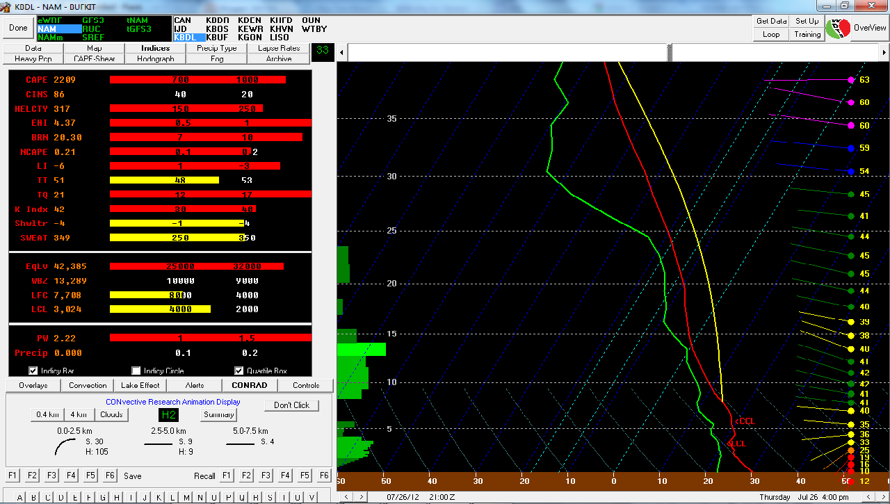
Check out this screen shot of one of our forecasting tools called the BUFKIT. On the left side you can see all the severe weather indicies are the color RED, indicating that they are in the high range.


One index that surprises and alarms me the most is the EHI or Energy Helicity Index: This is an index that combines instability and helicity (how wind speed and direction change with height) into one number for forecasting supercell storms.   Anytime this is greater than one, supercells are possible. The 12Z NAM is forecasting BDL (Windsor Locks) at a 4.37 for tomorrow at 4 PM!

Here is a link to a website showing you a key for some of the other indicies on the BUFKIT screen shot.

Significant Severe Weather Threat Tomorrow


 From the SPC (which has placed CT in the moderate risk for severe weather):


   ...MID-MS/OH VALLEYS TO THE NORTHEAST/SRN NEW ENGLAND...
   CONFIDENCE CONTINUES TO GROW WITH POTENTIAL FOR SCATTERED TO
   NUMEROUS ORGANIZED SEVERE TSTMS...PARTICULARLY FROM THE MIDWEST TO
   THE NORTHEAST. AN MCS SHOULD BE ONGOING ACROSS PARTS OF THE LOWER
   GREAT LAKES...SUPPORTED BY AN INITIAL MID-LEVEL SPEED MAX AND ROBUST
   LOW-LEVEL WAA ADVECTION. THIS SHOULD RETARD THE NERN ADVANCEMENT OF
   THE WARM FRONT AND SUBSEQUENT EVOLUTION OF THIS ACTIVITY DOES BREED
   UNCERTAINTY OVER WHERE THE FRONT WILL ULTIMATELY ANCHOR.
   
   AN EXPANSIVE UNCAPPED WARM SECTOR CHARACTERIZED BY 90S/60S SURFACE
   TEMPERATURES/DEW POINTS WILL CONTRIBUTE TO MODERATE TO STRONG
   BUOYANCY THU AFTERNOON WITH MLCAPE OF 2000-4000 J/KG. A LARGE SWATH
   OF 30-50 KT 700-500 MB WLYS WILL OVERLAP THIS INSTABILITY...AND WITH
   WEAK MID-LEVEL HEIGHT FALLS COMBINING WITH FRONTAL
   CONVERGENCE...THIS SETUP WILL YIELD SCATTERED TO NUMEROUS TSTMS
   FORMING ALONG AND AHEAD OF THE COLD FRONT. THE UNIDIRECTIONAL WIND
   PROFILES AND STEEP LOW-LEVEL LAPSE RATES SHOULD SUPPORT UPSCALE
   GROWTH INTO SEVERAL CLUSTERS WITH BOWING SEGMENTS AND EMBEDDED
   SUPERCELL STRUCTURES. DAMAGING WINDS /POTENTIALLY WIDESPREAD AND
   SIGNIFICANT/ WILL BE THE PRIMARY THREAT.
   
   A RELATIVELY NARROW CORRIDOR OF ENHANCED TORNADO RISK SHOULD DEVELOP
   ALONG THE WARM FRONTAL ZONE WHERE EFFECTIVE SRH AND STRONGEST
   DEEP-LAYER SHEAR WILL BE MAXIMIZED. ALTHOUGH PINPOINTING THIS
   CORRIDOR IS DIFFICULT GIVEN LIKELIHOOD OF PRECEDING OVERNIGHT
   CONVECTION...IT APPEARS MOST PROBABLE FROM PARTS OF NY INTO SRN NEW
   ENGLAND. SOME CONVECTION-ALLOWING GUIDANCE SUGGESTS THAT DISCRETE
   CONVECTION MAY FORM WITHIN A PERSISTING WAA REGIME THU AFTERNOON.

Tuesday, July 24, 2012

Storms Break The Humidity

After a humid start to the day, drier air is pumping in from the northwest. The push of comfy air followed severe storms that brought hail and minor wind damage to parts of the state. The storms began in Litchfield County this afternoon bringing nickel sized hail to New Milford. A separate cell dropped quarter sized hail in Sherman and Oxford. Then North Haven got pelted with pea sized hail.

 Here is some video of the hail in Oxford. Thanks to Jim for sending it in. And check out the pics of mammatus clouds from today’s storm in my previous blog post.


Tomorrow is my pick of the week with sunshine, mid 80s, low humidity and a gentle breeze. Beach anyone? The dry air won’t last. The humidity cranks up again on Thursday. The tropical moisture will also bring the return of slow moving strong storms with heavy downpours. Click here to see the SPC's convective outlook.


Scattered storms are also possible on Friday and Saturday. But the threat for strong storms is not as high. I'll keep you posted!

Mammatus Clouds

Check out the mammatus clouds that we caught outside the station today! This pic was taken by Al Chaniewski, one of out photographers.

Mammatus clouds are rare and are often associated with severe weather. The name "mammatus" is derived from the Latin word "mamma", meaning breast. I’m pretty sure we can all agree that a man drew this comparison when naming the cloud. A lonely man.


These clouds often form under cumulonimbus or storm clouds. Although they are often associated with severe weather, mammatus clouds can be a sign of weakening storms. Rain and hail cool the air at cloud level. Cooler air is more dense and sinks, colliding with the warmer air below and forming pouch like cloud formations.  I see pouches...you see mammas. Agree to disagree?

Tuesday, July 17, 2012

Heat Wave #5 Ends With A Bang

Another scorcher today! Record heat?  Close, but no cigar! Windsor Locks was one degree shy of the record high, topping out at 96 degrees.  Bridgeport hit 92, that’s three degrees shy of the record.

Although today was hot, the humidity wasn’t unbearable.  That will change tonight. The dew point is a measure of how much moisture there is in the air.  The higher the dew point, the harder it is for your body to sweat and the more uncomfortable you feel. The air feels comfortable with dew points in the 50s, humid in the 60s and oppressive with dew points in the 70s. Tonight/tomorrow dew points climb up near 70 degrees, ouch! 

Our hot and humid air mass will get replaced by a cooler, more comfortable alternative Thursday into the weekend.  But with big changes in the weather, you can count on big storms.


The Storm Prediction Center in Norman, OK has Connecticut under a “slight risk” of severe weather tomorrow (Wednesday).  But the SPC’s convective outlooks are almost always too conservative.  So every time you read the word “slight” on a map like this, upgrade it to moderate. The best chance for storms will come after noon.  So… tomorrow will start off partly cloudy, hot and humid.  Then keep an eye on the sky as those storms bubble up around or after noon. The storms are arriving a little earlier than I thought which is good news!  If the storms arrived in the late afternoon, they would take advantage of the peak heating/instability of the day and be much stronger!  Still I think some storms tomorrow reach severe criteria.


Thursday will still be warm (mid-upper 80s) just not as humid.  Friday and the weekend look cooler with temperatures dropping back into the lower 80s.  Refreshing!

Monday, July 16, 2012

Heat Wave #5

Heat wave #5 started today. Here is the 90 degree count so far this year for Bradley Intl. Airport (BDL).

Temperatures on Tuesday and Wednesday are also expected to soar into the 90s.  So by the end of Wednesday, BDL will hit the average # of 90 degree days and it's only mid July!  Even though it's turning out to be a hot summer, we are no where near the record of 38 90 degree days, set back in 1983.

Sunday, July 15, 2012

This Week: Hot Start, Comfy Finish

Another heat wave is brewing with three days the 90s (even along the shoreline) accompanied by tropical humidity. 

Although most of Monday will be sunny, an isolated shower or storm is possible late in the day.  Tuesday will be the hottest before a cold front approaches on Wednesday bringing the chance for showers and thunderstorms.  Some of the storms could be strong with heavy rain, gusty winds, hail and lots of lightning. Behind the front, temperatures and humidity levels will drift back into the comfortable category for the end of the week into the weekend. 

Frizz is a factor tomorrow!  Grab the can of hairspray and use liberally.  


Thursday, July 12, 2012

Return of the 90s

Hmmm...that doesn't the same ring to it as 'Return of the Jedi'.  But this is the best I can do with the material I'm working with.

Looking for a hot day to spend at the beach? You have plenty of 90 degree days to choose from! Friday and Saturday remain dry with partly sunny skies and temperatures in the low 90s inland, mid to upper 80s for the shoreline.  I guess I should say “mainly” dry. An isolated shower is possible for one or two towns.  But the vast majority of us will not see one.  Showers and storms will finally have a chance to wet the ground on Sunday. although the day will not be a washout, Saturday looks better for outdoor plans. 
Sunday will be steamy too with the return of tropical moisture and humidity. The only reason I didn’t forecast 90 degrees or better on Sunday is because I think cloud cover could become more of a player.  Showers will likely keep temps down from their full potential too.

Before you complain about the heat, just remember how much you'll miss it when we're digging out after our next nor'easter.

Wednesday, July 11, 2012

Boring Weather For A Meteorologist, Great For You!


Our brilliant stretch of summer weather continues.  My biggest forecasting headaches involve debating one or two degrees on the high temperature forecast.  (I'll always find something to stress about.)

Sunshine will mix in with some clouds Thursday afternoon. An isolated shower is possible. But only one or two towns in the state will get one. Temperatures are moving up, turning slowly warmer and more humid the next three days. If your lawn or garden is getting thirsty, water it yourself. Mother Nature isn’t helping.  Widespread showers hold off until Saturday night and Sunday, triggered by a warm front ushering in some very humid air.  Sunday we're back to "the soup" (air so humid you can taste the water in the air).  I'm sweating just thinking about it.  

Next week looks hot AND humid.  More beach weather.  But I prefer this week's low humidity.

Monday, July 9, 2012

Relief Continues For Now


Relief from the summer sizzle continues the next two days with no humidity and temperatures rising comfortably through the 80s. Save yourself some cash and open the windows tonight!  Temperatures will tumble into the 50s.  I love a cool summer night.

Sunshine will greet you tomorrow morning with fluffy clouds popping up during the afternoon. There is a slight chance for a sprinkle on the computer models.   But I’m not seeing a lot of moisture in the atmosphere.  So I think most if not all of Connecticut stays dry.  So when will the heat return? Late week!  By Friday temperatures will flirt with the 90 degree mark and the humidity makes a comeback by this weekend, making the air feel like soup again.  

Warmest 12 Months On Record For The US!

The lower 48 states just set a new record for the warmest 12 month period since record keeping began back in 1895!

The NOAA (National Oceanic and Atmospheric Administration) reports the average temperature in June for the contiguous US was 71.2 degrees. That's a full two degrees above the 20th century average.

The heat wave baking most of the country in the second half of June helped break or tie 170 all time high temperature records.

Check out all the extreme weather events from last month alone!

Sunday, July 8, 2012

A Break From The Summer Sizzle

Our summer fever finally broke!  High pressure will bring less humid air and slightly cooler temperatures the next few days. Tonight will be great for sleeping.  You can actually open the windows and let some fresh air in.  temperatures will drop down around the 60 degree mark.

Monday will remain mostly sunny with fluffy fair weather clouds popping up.  A sea breeze will develop in the afternoon keeping the shoreline cooler than inland areas. High temperatures will climb into the mid to upper 80s with no humidity! A wave of low pressure riding along a front stalled over the mid-Atlantic will bring the chance for a shower or two on Tuesday, but most towns should stay dry. The humidity doesn’t return until next weekend!

Monday, July 2, 2012

Oh Hail!

Here are just a few hail pics and a video just in case you missed out on the nasty storms on Sunday!
Tom Emmanuele, Cheshire

 
 Ed, Watertown 


Jess, Cheshire

 Steve, Cheshire

 Wind Damage in Woodstock on RT 198, Josh Bottone

Sunday, July 1, 2012

Large Hail Today, Storms Return July 4th

I have never seen so many storms with large hail in Connecticut. Hail the size of ping pongs fell from Litchfield county down to Old Saybrook with a long duration supercell. Although other hail was reported across the state, that one storm was by far the meanest. Check out the path of hail reports below (everywhere you see the purple hail icon).

Although tomorrow will not be as humid, it’s still hot with temperatures in theupper 80s. Sunshine will stick around the next two days. But watch for storms to redevelop just in time for the fourth of July. Morning clouds and showers will break for sun. The more sun we get in the afternoon, the better chance we have of seeing severe weather. So keep that in mind when you planning for the holiday. Mother Nature might be making her own fireworks. I know. That was a horrible weather joke.

Congrats Miss Connecticut 2012!!


Congratulations to Jaine Coann Lefevbre - Miss Connecticut's Outstanding Teen 2012 and to Miss Connecticut 2012- Emily Audibert! Check out the photo gallery on the Courant website.  It was a long three days.  I went from being a stranger to the Miss Connecticut Scholarship Pageant, to a big fan!  I feel like I got to know the contestant's personalities.  I also see how competing in pageants helps woman grow by developing their interview skills and talents.  


You don't even want to know the kind of chaos going on behind the scenes.  There were constant re-writes, additions, changes...it was insane!  Thankfully Lisa was back stage to help me!


I had another gorgeous gown from the Crowning Touch in New Bedford, MA and thanks to Stephanie for my hair and makeup!

Instagram @RachelFrankCT