Create Your Own Wine, Beer And Soda At Cork And Brew
They’ve uncorked something new to Connecticut, a place where you can make your own wine, brew your own beer, and concoct your own soda. There is lots brewing on North Main Street in Southington at Cork & Brew where your inner vintner can come out.
I got to make a cameo in this story, without even knowing about it!

Friday, December 23, 2011
How To Perfectly Wrap Gifts
Well Erika learned how to professionally wrap. They just had me throw an old shirt over my gift. Somehow I managed to start singing in the middle of the interview. Typical. Watch here.
Thursday, December 22, 2011
Three Winters
There are three different definitions of winter.
Solar winter: November - January
is the quarter of the year with the lowest sun angle and shortest days.
Meteorological winter: December-January
is the coolest quarter of the year with the lowest average temperatures and the most snow and ice.
Astronomical winter: December 22-March 20
is the most familiar to you! Astronomical winter has to do with the earth position in relation to the sun. It begins during the winter solstice (when the sun is lowest in the sky) to the spring equinox (when the sun is directly over the equator).
So meteorological winter and solar winter are already over, that's 2/3. Not bad. 19 days to go and it will be spring on every calendar!
Wednesday, December 21, 2011
Winterizing Your Car
When it comes to tire traction, kitty litter is better than sand. Who knew?
Watch my live interview from Morning Extra here!
Watch my live interview from Morning Extra here!
Thursday, December 15, 2011
Champurrado (Mexican Hot Chocolate)
Watch Steve Yopp, executive chef of Besito make Champurrado, or Mexican hot chocolate! It was so good! The flavors are more complex than regular hot chocolate and it has a thicker consistency.
Ingredients:
4 cups Milk
½ cup Ground Mexican Chocolate ½ cup Dark Chocolate 1 stick Canela (Mexican Cinnamon) 3 tbsp Corn Masa ½ cup Sugar(Optional)
Steps to Make:
1. Heat the milk gently over medium heat, with cinnamon stick.
2. Stir in both types of chocolate, whisking constantly so it doesn't stick.
3. Once chocolate has melted, stir in the corn masa to desired thickness. Add sugar if desired.
Serving Suggestions:
1. Serve with warm churros.
2. Serve with peppermint stirring sticks.
3. Serve with bunuelos(crispy cinnamon sugar flour tortillas)
Dreaming Of A White X-Mas

Will we have a white Christmas? It's an age-old question that occurs to almost everyone this time of year. The National Climatic Data Center calculated the chance of a white Christmas by looking at a 30 year average from 1961-1990. I think their results are too high for Bridgeport and Hartford.
Hartford
57% chance of an inch on the ground
27% chance of 3"
3% chance of 10"
Bridgeport
30% chance of an inch on the ground
10% chance of 3"
0% chance of 10"
A 50/50 shot at a white Christmas in Hartford? And Bridgeport is white 3 out of 10 years? Hmmm...that doesn't seem right. Maybe the sample years were too cold. When I ran some calculations using weatherspark.com, I got a 25% chance of a white Christmas in Hartford. That makes more sense. And Bridgeport has an 11% chance of at least some snow on the ground. Either way, it's not looking too good for us this year with no arctic air in sight. We could see a little snow next Wednesday in the higher elevations, but right now it doesn't look like enough to coat the ground. At this point we'll take what we can get!
Sunday, December 11, 2011
Last Wed/Thu: Rain, Wind, & A Touch Of Snow
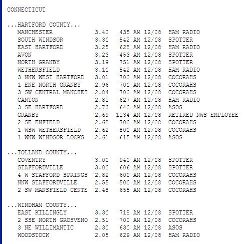
Little or no snow fell in Hartford and points south and east. I did think we would get more accumuation in the Litchfield hils. But the cold air didn't come in fast enough! Still, there were plenty of school delays in the higher elevations where it looked like a winter wonderland for a little while.
This was more of a rain and wind storm than anything else. A peak wind gust of 56 mph was reported in New London! There were scattered power outages all over the state!
Snow totals:
Norfolk: 2.8"
Tolland: 1.0"
Staffordville: 1.0"
Coventry: 0.5"
Stafford Springs: 0.3"
Bakersville: 0.3"
Rain Totals:


This was more of a rain and wind storm than anything else. A peak wind gust of 56 mph was reported in New London! There were scattered power outages all over the state!
Snow totals:
Norfolk: 2.8"
Tolland: 1.0"
Staffordville: 1.0"
Coventry: 0.5"
Stafford Springs: 0.3"
Bakersville: 0.3"
Rain Totals:

Friday, December 9, 2011
Wettest Year On Record!
Pat yourself on the back. We deserve some recognition after the wet year we survived! It all started with record breaking snowfall in January, then it was remnants of tropical storm Lee, tropical storm Irene, an October Nor'easter and lastly a rainy Tuesday/Wednesday.
Now 2011 will go down in the record books as....
THE WETTEST YEAR ON RECORD!!
2011: 66.97"
Previous record (2008): 65.42
Records for Windsor Locks date back to 1905. And the year is not over yet!
Now 2011 will go down in the record books as....
THE WETTEST YEAR ON RECORD!!
2011: 66.97"
Previous record (2008): 65.42
Records for Windsor Locks date back to 1905. And the year is not over yet!
Wednesday, December 7, 2011
More Wet Than White
I have adjusted snowfall accumulations down a smidge. Little or no accumulation for areas south and east of Hartford. A slushy coating to an inch everywhere else. The exception will be northern Litchfield County which can still pick up 2"-5" of wet snow. Here is the 9Z NAM. I like it better than the 12Z which looks a little too cold. Ski/Snowboard areas in MA/VT/NH could get anywhere from 3"-12" of snow. The changeover to snow will occur too late for plowable snow for the vast majority of CT. Rain is the bigger issue here. As of today, this is the 2nd wettest year on record for Windsor Locks and we only need a half inch to make it to the #1 spot. Will we make it? I would take that bet considering the models have another 1"-2" of rain falling tonight! A flood watch is issued for all of CT. Minor flooding is possible for small streams, creeks, low lying areas and poor drainage areas.

The storm is out of here around sunrise tomorrow. The rest of the day will be breezy and cooler with temps in the 40s and gusts up to 30 mph. Look for a chill to settle in this weekend with highs in the 30s. Look at the calendar before you complain. ;)
 Rain is the bigger issue here. As of today, this is the 2nd wettest year on record for Windsor Locks and we only need a half inch to make it to the #1 spot. Will we make it? I would take that bet considering the models have another 1"-2" of rain falling tonight! A flood watch is issued for all of CT. Minor flooding is possible for small streams, creeks, low lying areas and poor drainage areas.
The storm is out of here around sunrise tomorrow. The rest of the day will be breezy and cooler with temps in the 40s and gusts up to 30 mph. Look for a chill to settle in this weekend with highs in the 30s. Look at the calendar before you complain. ;)
Tuesday, December 6, 2011
From Warm To Wet To...White??
 WOW! 50s again today!? No wonder no one believes me when I tell them it’s December! The cold front preceding cold air to our west has stalled. That means we have one more mild, showery day before temperatures tumble.
Tonight: mild with shower and patchy fog. Low: 45-50.
Keep in mind, the low temperature tonight is above the average high temperature for this time of year!
Tomorrow: Times of rain, mild: High 50-55.
The heaviest rain falls tomorrow night when a low developing on the stalled front moves off the NJ coast. Although the storm looks stronger, it also looks a milder than previous model runs. Rain will mix in or change over to wet snow at the very last minute Thursday morning. Shoreline and valley locations will get little or no snow accumulation and the higher elevations of ct could pick up a slushy inch or two. The exception will be the hills of Litchfield county where 3”-6” of snow is possible, with higher amounts along the Massachusetts border. I expect a changeover to snow after 2 AM in these locations.
The storm is completely gone by 9 am Thursday with the wind picking up and falling temperatures. Overall…the changeover to snow has bad timing because some people will be on the road, but for most of the state this is a non event or a nuisance event. Western Massachusetts and Litchfield County will have more “fun” with a nice plowable snow. Let’s just hope it’s not another power outage maker.
Liquid equivalents will range between 1”-2”! We are only 1.2” away from the wettest year on record in Windsor Locks. I think this storm will put us over the edge helping up achieve that record. After all we’ve been through this year, we deserve it!
Friday, December 2, 2011
December Preview
My new addiction is weatherspark.com. The site takes boring weather stats and turns them into easy-to-read (pretty) weather charts and graphs.
The month of December is characterized by falling daily high temperatures (thank you captain obvious). Daily high temps decreasing from 46°F to 38°F over the course of the month. Daily low temperatures range from 24°F to 31°F.
Daily High and Low Temperature in December The daily average low (blue) and high (red) temperature with percentile bands (inner band from 25th to 75th percentile, outer band from 10th to 90th percentile).
 The likelihood of snow falling is highest around December 31, occurring in 28% of days.
The month of December is characterized by falling daily high temperatures (thank you captain obvious). Daily high temps decreasing from 46°F to 38°F over the course of the month. Daily low temperatures range from 24°F to 31°F.
Daily High and Low Temperature in December
The daily average low (blue) and high (red) temperature with percentile bands (inner band from 25th to 75th percentile, outer band from 10th to 90th percentile). Fraction of Time Spent in Various Temperature Bands in December The average fraction of time spent in various temperature bands: frigid (below 15°F), freezing (15°F to 32°F), cold (32°F to 50°F), cool (50°F to 65°F). Notice the average amount of time we spend below freezing increases throughout the month.
Types of Precipitation Throughout December Relative frequency of various types of precipitation over the course of a typical December.
Light rain is the most severe precipitation observed during 29% of those days with precipitation. It is most likely around December 1, when it is observed during 17% of all days.
Light snow is the most severe precipitation observed during 28% of those days with precipitation. It is most likely around December 31, when it is observed during 18% of all days.
Moderate rain is the most severe precipitation observed during 16% of those days with precipitation. It is most likely around December 2, when it is observed during 9% of all days.
Moderate snow is the most severe precipitation observed during 12% of those days with precipitation. It is most likely around December 31, when it is observed during 8% of all days.
Probability of Snow Fall Being Reported in a Given Day in December
 The likelihood of snow falling is highest around December 31, occurring in 28% of days.
November Summary: Mild & Sunny!
November is notoriously cloudy. According to weatherspark.com, a website that collects and charts climate data, November is “cloudy” or “mostly cloudy” 55% of the time. See below.
 Not this year. This year the sky was cloudy only 30% of the time with 21 days spent partly cloudy or clear conditions.
This November was also very mild with an average high temperature of 57.2 degrees. We had 13 days in the 60s. And the average temperature was 4 degrees above average!
Precipitation was right around average with 3.81”. But the rain was concentrated with only five days recording over 0.03” of rain. So most of the month was dry!
This doesn’t mean anything about how we will spend our winter. A mild November doesn’t mean a mild December. In fact, sometimes Mother Nature usually finds a way to make sure everything balances out in the end.
Winter Is Here....Huh?
Welcome to winter! Huh? I know, I know. Your calendar says winter starts December 22nd when the sun’s rays shine over the tropic of Capricorn. That’s astronomical winter. But in meteorology, we like to keep things simple.
The coldest quarter of the year is December through February. So we call those three months, meteorological winter. So here we go snow lovers….it’s only a matter of time before I’m ripping out my hair forecasting our next snow storm. In the short term, I don’t see much cool air until the end of next week.
The coldest quarter of the year is December through February. So we call those three months, meteorological winter. So here we go snow lovers….it’s only a matter of time before I’m ripping out my hair forecasting our next snow storm. In the short term, I don’t see much cool air until the end of next week.
Subscribe to:
Posts (Atom)