Geek Alert courtesy of the National Weather Service in NY:
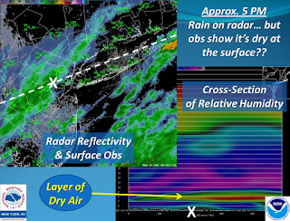
If you happen to be looking at a radar image this evening, you'll see it picking up rain across a good portion of the area. However, until recently, many sites (with rain overhead according to radar) were indicating no rain.
What's going on here?
A vertical profile of relative humidity values indicates why:
A layer of dry air around 5000 ft (yellows and reds) is causing most of the rain to evaporate before reaching the ground. For reference, the white X's are in the same location on each image.
Slowly this layer should diminish, however, and allow most locations to see rain this evening and tonight.


No comments:
Post a Comment