THANKS FOR VISITING!

I'm an Emmy Award Winning meteorologist at Fox 61 in Hartford. For the latest forecast updates (and fun stuff too, like food and family pics), please follow me on Facebook, twitter and instagram. I look forward to interacting with you there!

LIKE ME ON FACEBOOK!

Saturday, June 30, 2012

Miss Connecticut Night Two

Second night in and I'm already starting to get to know some of the girls.  I'm normally a nervous wreck before big public speaking enagements.  (I can't actually SEE the people watching me on TV on a nightly basis.) But tonight I'm more nervous for the ladies!  They all put so much hard work into the scholarship competition. I have my favorites...even though I'm not supposed to.

Here is a pic of me with Miss CT 2011(far right), Miss Outstanding Teen 2011 (far left) and the winners after the preliminary competition.


I can't actually see the people in the audience because the lights are so bright.  So it's really hard to picture them naked.

Thanks again to Crowning Touch Salon in New Bedford, MA for the dress and Brian Fortin for doing my makeup and styling my hair (both the real and the fake curly extensions).

Friday, June 29, 2012

I'm Hosting Miss Connecticut!

I just finished the first night of preliminaries including competitions in fitness, evening gowns, interviews, talent...this is intense!  I don't envy the pressure these girls are under!  Katie Stevens made a surprise appearance last night.  I guess the American Idol star was a runner up for Miss Outstanding Teen a couple of years ago.

These women sure know how to strut their stuff on stage! Walking around in a swimsuit at the beach is tough enough, but to do it in front of an audience takes balls....er...guts.

The Crowning Touch Salon in New Bedford, MA provided my attire last night.  They brought two garment bags full of dressses.  There was just one problem.  None of them fit me.  Note to self, don't watch a YouTube video on how to take your own measurements.  Apparently I told them I had JLo's booty. A girl can dream, can't she? We still made it work.  Thank you Marla for helping to pin me in all the right spots so I didn't fall out of the dress! On the final night of compeition I'll be channeling my inner Lady Gaga. 

Brian did my hair and makeup...Yes, I'm under all those eyelashes! Apparently my sister showed this pic to my grandparent's last night and there response was "who is that?"

The ladies taught me how to pose pageant style.  One leg in front of the other (the leg on the side of the slit).  Hand on your hip. I borrowed "pageant shoes" from Morgan Amarone, Miss CT 2011.  What are pageant shoes you ask?  After intense study, I have concluded that they're just classy low profile platforms.  Very comfy. Oh and the dangly earrings are clip ons.  They don't hurt until you take them off and the blood rushes back into your ears.  Pain is beauty.

Wednesday, June 27, 2012

Mean E-mails

I would like to preface this by saying that I get a lot of really nice messages from people.  Every time I do, I get an extra skip in my step, it makes my day!

But every once in a while I get a nasty e-mail that bothers me for weeks. I know I'm supposed to have a thick skin being in the public eye...apparently mine is still growing in. People always ask me what kind of "mean" e-mails I get.  Here is the latest one!

Rachel,
 We watch Fox news every night because we like to get the lottery results;unfortunately,you do the weather before the numbers are drawn and in are opinion and many other people we have spoken to you show far too much skin and find your clothing style very in appropriate for tv viewing especially if children happen to be watching.For example,the white dress you were wearing was far too short and also very unattractive.You are the only one on the broadcast who dresses this way.Take a look around at your co-workers and you might see what I am talking about. Time to grow up Rachel.


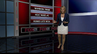
On another note, I'm super excited about the new "virtual studio" graphic I created!

Monday, June 25, 2012

Powerful Storms Break The Humidity


The threat for severe weather is over! The first round of storms moved through from 7 AM – 10 AM.  I don't know about you but I couldn't stay asleep with all that thunder! I kept feeling the need to grab my phone and refresh the radar.  The second line of storms developed around 2:30 PM in Litchfield County then fell apart in eastern Connecticut around 6 PM.  There were many reports of lightning strikes along with small hail,  flash flooding and wind damage.  Thousands of Connecticut residents were left in the dark!

A lingering shower or storm is possible early tonight. Then skies will turn partly cloudy and the humidity will drop.  Tonight will be cooler and comfy so you may want to keep the windows open tonight!

The area of low pressure that triggered severe weather today will slowly move offshore.  But the effects of that storm will still be felt  tomorrow.  Tomorrow will feature a mix of sun and clouds.  But any sun that we get will actually help increase the instability in the atmosphere.  A few showers or a rumble of thunder are possible, especially in the afternoon. Tomorrow temperatures will remain seasonably cool, in the 70s. In fact, some of you may call tomorrow "cool", at least for a day in June!

Watch for a warm up starting on Wednesday.  Temperatures will be back flirting with the 90 degree mark later this week! 

Sunday, June 24, 2012

Cooler But Wet!

Here is the cool down many of you were waiting for! . But the cooler temperatures come with a wet price tag An approaching cold front will cause clouds to thicken up tonight. Showers and areas of rain will develop after midnight. Monday will feature lots of clouds with periods of rain and scattered thunderstorms.

Some of the storms could be strong with lots of lightning and heavy rain. Tuesday will be even cooler with mostly cloudy skies and the chance for a scattered shower. Temperatures will begin to warm up on Wednesday with a mix of sun and clouds. By the end of the week, temperatures climb up near 90 again!

Tuesday, June 19, 2012

June Heat...Records Will Fall


Summer arrives June 20th at 7:09 PM and the season will kick off with record breaking heat and a heat wave with three days in a row of temperatures in the 90s! The dramatic change begins Wednesday as blow torch southwesterly winds pump in the sizzling heat and humidity that has been roasting much of the nation.

A Heat Advisory is in effect for parts of central and western Connecticut from noon to 8 PM Wednesday.  A Heat Advisory is issued when the combination of heat and humidity create a situation where heat illness is possible.  The heat index will be between 99-104 degrees for inland Connecticut. That’s how hot it will feel outside!

An Air Quality Alert is in effect for southern Connecticut including Fairfield, New Haven, Middlesex, and New London Counties. Ground level ozone will be at unhealthy levels for sensitive groups from 11 AM to 11 PM Wednesday. Those with respiratory problems should limit the amount of time spent outside.

Temperatures both Wednesday and Thursday will range between 95-100 degrees inland, 90-95 along the shoreline. The shoreline temperature is a little trickier. Any shift in wind over the Long Island Sound will keep temperatures cooler than inland areas. But if the wind stays westerly, temperatures will skyrocket! The humidity will be higher on Wednesday but temperatures will be slightly higher Thursday.

How rare is this June heat? Connecticut has only hit 100 degrees in June twice on record (records date back to 1905).  This could also be the earliest 100 degree day on record. The record high temperature in the greater Hartford area is 96 degrees both Wednesday and Thursday. The record high temperature in Bridgeport is 93 degrees on Wednesday and 95 degrees on Thursday. Those records will be challenged or broken!

Friday also looks hot but not as oppressive with temperatures near 90. A cold front will likely break the heat late day and may be accompanied by thunderstorms.

Monday, June 18, 2012

Warmer Tomorrow, HOT Wednesday & Thursday

Summer arrives June 20th at 7:09 PM and the season will kick off with record breaking heat! You still have tonight and much of tomorrow to prepare for the excessive heat and humidity that will peak Wednesday and Thursday.

The warm up begins tomorrow with temperatures in the low 80s inland, mid 70s at the coast. The air will feel muggy but not uncomfortable. Tuesday’s weather will be fairly typical for late June. But Wednesday and Thursday are far from average June heat. In fact, we could break records. Blow torch southwesterly winds will pump in the heat and humidity that has been roasting much of the nation. Temperatures both days will range between 95-100 degrees inland, 90-95 along the shoreline. The humidity will make it feel like 100+ degrees.

The last time temperatures were this warm was in late July of last year! The record high temperature in the greater Hartford area is 96 degrees both Wednesday and Thursday. The record high temperature in Bridgeport is 93 degrees on Wednesday and 95 degrees on Thursday. Those records will be challenged or broken! Friday also looks hot but not as oppressive with temperatures in the 80s to near 90. A cold front will likely break the heat late day and may be accompanied by thunderstorms.

Sunday, June 17, 2012

Heating Up Just In Time For Summer!


This week will start off comfortable and end hot! Temperatures will climb each day this week, peaking on Thursday with temperatures in the 90s all the way down to the shoreline.

Tonight will remain comfortable with temperatures tumbling through the 50s with a nice dry air mass in place. Clouds will increase slightly overnight due to a weak northeasterly wind bringing in moisture off the water.

Any leftover morning clouds and fog will burn away on Monday revealing mostly sunny skies. Temperatures will climb into the 70s. Tuesday will be warmer (80s) and a bit muggy, but not uncomfortable.  Real hot and humid summer weather arrives on Wednesday.  The record high temperature is 96 for the Hartford area on Wednesday and Thursday. Those records are in jeopardy!  If everything works out perfectly....triple digits are possible!

Tuesday, June 12, 2012

I Fired Geoff (Sort Of)


This is from the new app  ActionMovieFX on iPhone!  it's free and I can't put it down!  Geoff was a good sport.  

Monday, June 11, 2012

Another Nice Day Before Some Rain


Last Monday felt like April with temperatures struggling through the 50s.  Fast forward one week and June weather has returned!  Today will be partly sunny with temperatures in the 70s to near 80 degrees. High pressure over the Gulf of Maine will help keep us dry for now. But an approaching cold front will cause clouds to thicken up tomorrow. Showers move back in by late tomorrow or tomorrow night.  Wednesday also looks wet at times.  Rain will return, but at least April temperatures don’t!

Wednesday, June 6, 2012

Slow Warming, Afternoon Shower Threat Continues

Scattered showers will diminish tonight after the sun sets.  Temperatures will stay in the 50s with partly cloudy skies.

Temperatures will climb a bit higher tomorrow but the rest of the forecast remains the same.  Look for intervals of sun and clouds with some pop up showers and thunderstorms, mainly in the afternoon.  The warming trend continues Friday with one more day of afternoon showers.

80s return this weekend.  If a warm front moves through on Sunday, next week will turn hot. But the front could get hung up south of the area keeping temperatures closer to average.  Showers are likely Sunday morning.

Tuesday, June 5, 2012

Cloudy For The Transit Of Venus, Summer Returns This Weekend!

June weather remained on hold today. All of this cool weather is caused by the combination of deep trough in the East and a strong ridge in the West. Basically, there is a traffic jam in the atmosphere! Scattered afternoon showers will pop up each day through Friday. After the sun sets, any leftover showers should dissipate.

Although we expect a lot of clouds around tonight for the transit of Venus, you might get lucky and see a small break in the clouds at some points tonight. But you don’t have to wait a lifetime to see this phenomenon! Check out this live feed of the transit on NASA! 

A Coastal Flood Advisory is in effect again tonight for western Long Island Sound with tidal departures 1.5 feet above astronomical high tide. This will bring some minor to moderate flooding to the same coastal towns that were impacted last night. High tide occurs just before 1 A.M.

Slow improvement continues tomorrow with a bit more sun poking through the clouds at times. But any sun we see will actually work against us by energizing the air and producing a few pop-up afternoon showers and thunderstorms. Temperatures will climb into the upper 60s and low 70s, which is milder than the last two days. Afternoon showers stay in the forecast through Friday.

This weekend, the stubborn trough will finally move out, and winds will become southerly, transporting summer time heat! Temperatures soar into the 80s this weekend, with 90s possible by early next week!

Monday, June 4, 2012

Near Record Chill

You have heard of record high temperatures and record low temperatures.  But have you ever heard of a record low max?

On the far left is the record for the "lowest high temperature" for June 4th. In other words, a high temperature has never been cooler than 59 degrees on June 4th. Today we came one degree shy of that record!  That's what clouds and a northeasterly flow will do for you.  Tomorrow will not be as cool with 60s all across the state and 70s by Thursday and Friday. Check out my previous post for the forecast details!

Slow Improvement

Cool, raw, soggy, blah. What happened to June? The average high temperature on June 4th is 77 degrees. Today we got stuck in the 50s.

 But don’t blame your friendly meteorologist. A stubborn upper level storm has slammed the brakes on the northeast and continues to churn up unsettled weather. Although showers will remain in the forecast through Friday, each day offers slow improvement.

Tonight temperatures will drop into the 40s inland, near 50 along the shoreline with a few lingering showers. A Coastal Flood Advisory is in effect for the western Long Island Sound. This has nothing to do with the rain. But a steady northeast wind has been piling water into the Long Island Sound. That effect combined with astronomically high tide will cause tidal departures up to 1 ¾ greater than normal. This will result in some very minor flooding along the immediate shoreline.

Tomorrow remains mostly cloudy. You may see a few intervals of sunshine. But if that happens, consider it a bonus. Grey is the overwhelming color of the day. Even though most of the day will stay dry, keep your umbrella handy with some scattered showers.

Wednesday through Friday look much better with steady improvement. Each day will feature some sun to start followed by afternoon pop up showers and storms. Temperatures will slowly rebound through that time as well, returning to the 70s Thursday and Friday.

A return to summer warmth is less than a week away. Right now the weekend looks toasty with temperatures in the 80s and early next week could be a scorcher.

For my fellow geeks: Check out the feed of moisture from the tropics directly into New England today!

Sunday, June 3, 2012

Record Warmth In May & "Meteorological" Spring!

This May will go down as the 6th warmest on record with an average temperature of 63.8 degrees. This spring also featured record warmth! I know what you’re thinking. Spring isn’t over yet. Well, in the weather world we like to keep things simple. Spring is defined as the three transitional months leading up to summer: March, April and May. This spring was tied for the warmest on record! This year and spring of 2010 had an average temperature of 54.3 degrees! y. Here’s what surprised me! The NWS says we didn’t come close to the DRIEST spring on record. This year will not make the top ten, even with the rainfall deficit we carried for much of the year.

Not A Pretty Week. 50s Monday!

Strong storms this afternoon brought parts of the state heavy downpours, nickel sized hail and wind gusts up to 50 mph today. The strong storms have moved out. Other than a lingering shower in spots early tonight, the rest of the evening looks dry with mostly cloudy skies and temperatures dropping into the 50s. Upper level low=crappy weather this week. Look for a few showers each day through Friday! Tomorrow will feel like April with temperatures struggling in the 50s and lots of clouds. Although most of the day will be dry, keep the umbrella handy with some scattered showers. Tuesday will be similar. The rest of the week brings slow improvement as a storm in the upper levels of the atmosphere starts to move out. Each day Wednesday through Friday features some morning sun, followed by clouds and the chance for a scattered afternoon shower. Drier weather arrives in time for next weekend!

Instagram @RachelFrankCT