
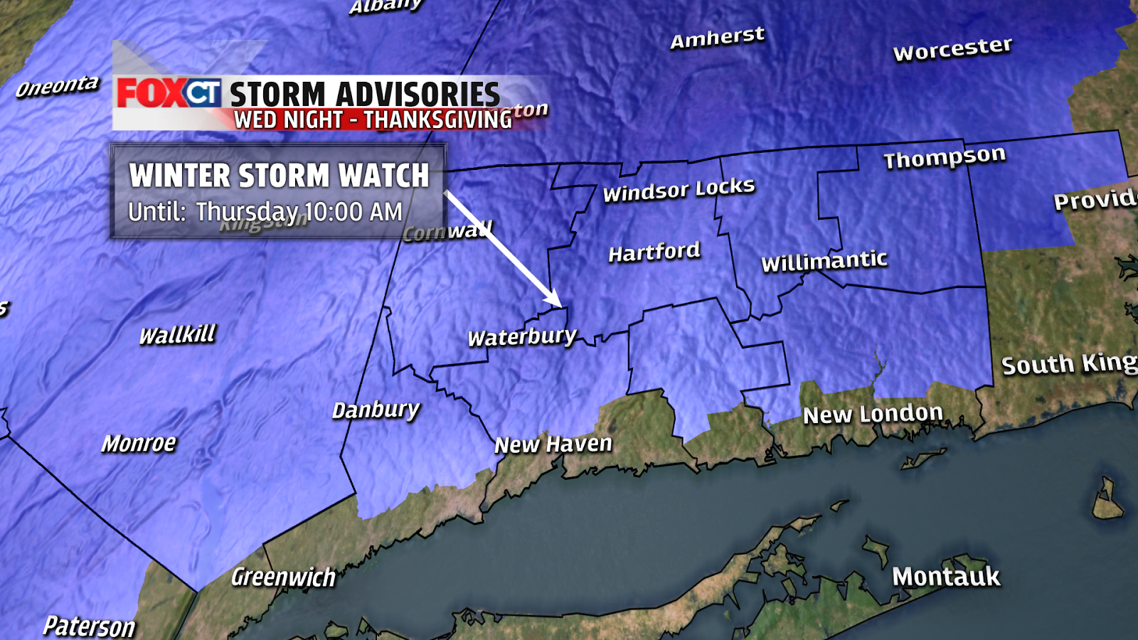
Weather Headlines
- Timing: 7-10 AM Wednesday morning – just after midnight Thursday morning
- The worst is Wednesday late afternoon and Wednesday evening
- 6"+ north of I-84, less farther south and east
Forecast Discussion:
With highs soaring through the 60s you would never guess we have a winter storm on the way. And lucky us…just in time for the busiest travel day of the year.
With highs soaring through the 60s you would never guess we have a winter storm on the way. And lucky us…just in time for the busiest travel day of the year.
If you need to do any traveling or errands before
Thanksgiving, try to get it done on Tuesday. We will squeeze in one more mild
day with high temperatures in the upper 50s to around 60 degrees.
This storm will be born in the Gulf of Mexico before riding northeast
bringing, snow, rain or a mix for many east coast cities and airport hubs.
 But what can we expect here in Connecticut? A mix of rain, snow
and sleet will develop between 7-10 AM (location dependant). Then as some
colder air is wrapped into the storm, precipitation will slowly change over to
all snow from northwest to southeast during the afternoon and evening. Since
areas north of I-84 remain mostly snow, that’s where we’re expecting the
highest accumulations with 6”-10” possible. We’re forecasting 3”-6” south of
I-84. The valleys will get less than the
higher elevations. Then along the shoreline we’re only expecting a slushy 1”-3”
where the most mixing will take place. The storm ends a little after midnight
early Thursday morning.
But what can we expect here in Connecticut? A mix of rain, snow
and sleet will develop between 7-10 AM (location dependant). Then as some
colder air is wrapped into the storm, precipitation will slowly change over to
all snow from northwest to southeast during the afternoon and evening. Since
areas north of I-84 remain mostly snow, that’s where we’re expecting the
highest accumulations with 6”-10” possible. We’re forecasting 3”-6” south of
I-84. The valleys will get less than the
higher elevations. Then along the shoreline we’re only expecting a slushy 1”-3”
where the most mixing will take place. The storm ends a little after midnight
early Thursday morning. The National Weather Service is forecasting higher
accumulations than we are. There are a
few reasons I remain less enthusiastic about lots of snow. The first one is milder surface temperatures. 1) There is no blocking high to the north to
lock in the cold. An easterly wind off the milder November water temperature doesn't help either! 2) The best moisture and lift do not coincide with the
snow growth zone (the area in the atmosphere where those big flakes usually
form). This can lead to snow to liquid ratios under the average 10:1. 3) This is a quick hitter and we waste precipitation in the form of sleet or rain at the onset.
The National Weather Service is forecasting higher
accumulations than we are. There are a
few reasons I remain less enthusiastic about lots of snow. The first one is milder surface temperatures. 1) There is no blocking high to the north to
lock in the cold. An easterly wind off the milder November water temperature doesn't help either! 2) The best moisture and lift do not coincide with the
snow growth zone (the area in the atmosphere where those big flakes usually
form). This can lead to snow to liquid ratios under the average 10:1. 3) This is a quick hitter and we waste precipitation in the form of sleet or rain at the onset.
Obviously, this forecast is not a “lock” yet. We are walking a fine line between all snow
and a mix of sleet and rain. But so far
I feel confident about this forecast. No
matter how much snow accumulates, Wednesday is going to be an icky day to
travel!
Forecast Details:
Tonight: Mild! Low: 47-52.
Tomorrow: Partly to mostly sunny, mild. High temperatures in
the upper 50s to around 60 degrees.
Wednesday: Rain and/or mix developing 7-10 AM. Changing to
wet snow during the afternoon/evening. High temperatures in the middle 30s.
Thursday: Slick roads early. Breezy and cool with a mix of
clouds and sun. High temperatures in the
mid 30s to around 40 degrees.
Friday: Partly cloudy and chilly! High temperatures in the
middle 30s.
Saturday: Partly cloudy, remaining chilly. High temperatures
in the upper 30s to around 40 degrees.
No comments:
Post a Comment