
Friday, December 31, 2010
Wednesday, December 29, 2010
Weather From 12/29 With Sarah Palin Hair
You know those annoying commercials for Bumpits!? I'm wearing one in my hair! Hahaha....They were $5.99 at Walgreens and I couldn't resist!
Lead in story was about how a North Carolina jeweler promised to refund all diamond purchases if it snowed 3" or more on X-Mas. It snowed 6" there!! We would have a lot of broke jewelers if they started making deals like that here in CT!
Lead in story was about how a North Carolina jeweler promised to refund all diamond purchases if it snowed 3" or more on X-Mas. It snowed 6" there!! We would have a lot of broke jewelers if they started making deals like that here in CT!
Tuesday, December 28, 2010
Monday, December 27, 2010
Christmas Blizzard
Although snowfall totals were not epic, this storm will really be remembered for the high winds!

- Greenwich: 60 mph
- Danbury: 60 mph
- Bridgeport: 60 mph
- New Haven: 60 mph
- New London: 68 mph
Dry air wrapped around the storm last night, choking snowfall rates in eastern and central Connecticut (6"-10"). Meanwhile the western part of the state got into some of the heavier snow bands (10"-18"). See the graphic below. The purple shaded area in NY is the 15"-30" band, where the heaviest snow fell. This is of course an average snowfall amount for various parts of the state.

- Wilton: 18"
- Greenwich: 17"
- Norwalk:16"
- Southbury: 11"
- Granby: 8.o"
- East Hartford: 14"
- Burlington: 11"
- Glastonbury: 10.2"
- Hartford: 6.5"-14"
Here are links to more snowfall totals and peak wind gusts. Make sure to check out the 20"-30" snowfall reports in NY/NJ. My Mom and sister were right inside the bullseye!
I Can Explain!
I'm recapping the weather forecast at the end of the FOX Midday News. My graphics are full screen.
Tim Paul, our floor director motions for me to lean into anchor Anthony DiLorenzo. Something is wrong with his microphone so mine will have to cover both of us.
Then we come back out to the couch shot...AWKWARD!!

And Anthony has no idea why I'm offering my chest to him.

I got an puzzled look and an awkward giggle. Last time I let him borrow my microphone! ;) Just another live TV moment!
Tim Paul, our floor director motions for me to lean into anchor Anthony DiLorenzo. Something is wrong with his microphone so mine will have to cover both of us.
Then we come back out to the couch shot...AWKWARD!!

And Anthony has no idea why I'm offering my chest to him.

I got an puzzled look and an awkward giggle. Last time I let him borrow my microphone! ;) Just another live TV moment!
Sunday, December 26, 2010
Saturday, December 25, 2010
Snowfall Totals
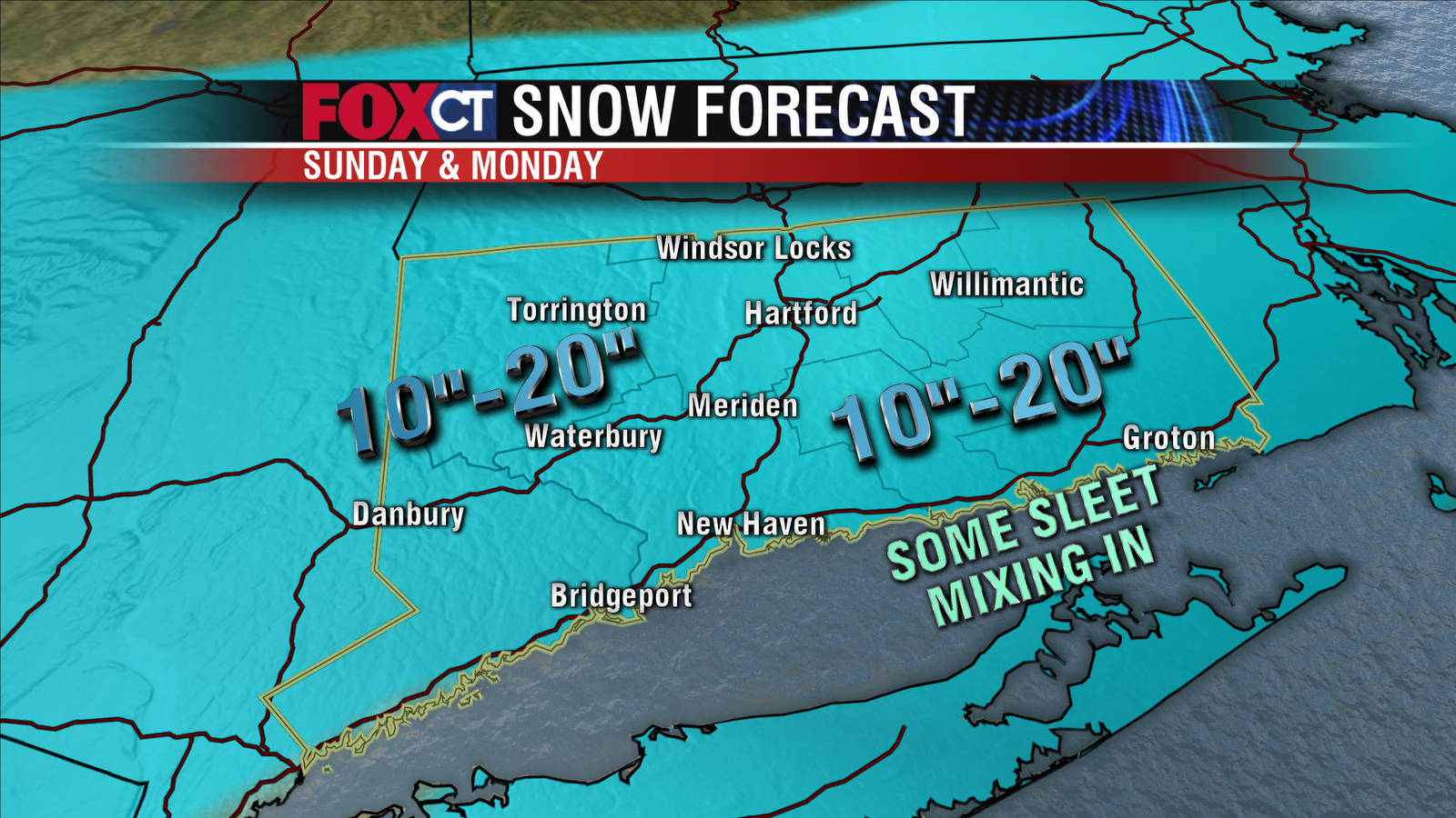
Most people will see a foot to a foot and a half of snow out of this storm! No matter how much snow falls, the wind is really a bigger issue because it will blow a lot of the snow around making it nearly impossible to see with blizzard conditions and zero visibility at times.
Southeastern Connecticut (New London) may see the lower end of the (10"-20") range with some sleet mixing in at times. The higher end of the totals will land where "mesoscale banding" occurs. These bands are nearly impossible to predict and are usually a few miles wide. Very heavy snow will occur in the bands, with thunder possible. Looks like they might set up in northwest CT but it's too early to tell.
Most of the snow that falls will be fluffy, powdery snow (the kind that is NOT good for making snowmen). But southeastern CT could see isolated power outages with a wetter, heavier snow.
Winter Storm Warnings

A Blizzard Warning is in effect for much of Southern CT from Sunday through Monday afternoon with snow accumulations over a foot in many areas and strong winds causing blowing and drifting of snow. Visibility will get down to zero at times making it dangerous if not impossible on the roads. Strong winds may also take down trees, power lines and Christmas decorations. Wind gusts could get up to 45-60 mph.
A Winter Storm Warning is in effect for the rest of the state from Sunday night into Monday. Snow accumulations will range from 10”-20”. Blowing and drifting snow will make for difficult and dangerous travel conditions. Snow will start off light Sunday morning getting steadier and heavier as the day progresses. The worst of the storm will be overhead Sunday night into early Monday with snowfall rates of 1”-3” per hour and whiteout conditions.
Here Comes The Snow! Poor Travel Conditions....
There is growing confidence that a moderate to major winter storm will impact Connecticut Sunday and Monday. The NWS has issued a Winter Storm Watch for late Sunday through Monday afternoon.
Timing
Sunday (during the day)
Some areas of snow around; activity will be mainly light. Snow will pick up in intensity around sunset.
Sunday night
Worst of the storm - this is when most of the snow will fall. Travel will be difficult or impossible during the storm’s peak. A strong wind will result in blowing and drifting of snow. Power outages are possible.
Monday
Snow will become less intense and taper to flurries and snow showers. If the storm were to stall, then a light snow could fall for most of the day. A strong wind will continue all day; resulting in additional blowing and drifting of the snow.
Timing
Sunday (during the day)
Some areas of snow around; activity will be mainly light. Snow will pick up in intensity around sunset.
Sunday night
Worst of the storm - this is when most of the snow will fall. Travel will be difficult or impossible during the storm’s peak. A strong wind will result in blowing and drifting of snow. Power outages are possible.
Monday
Snow will become less intense and taper to flurries and snow showers. If the storm were to stall, then a light snow could fall for most of the day. A strong wind will continue all day; resulting in additional blowing and drifting of the snow.
Friday, December 24, 2010
Storm Late Sunday - Monday
Dry and chilly for this Christmas Eve. Santa will have to hold on tight to your presents this evening with a breeze in place. Temperatures will drop into the teens and 20s tonight with frost possible by Christmas morning.
There will not be any problems Christmas Day weather wise with just an increase in clouds throughout the day. High temperatures will be near 30 degrees with a very light wind.
On Sunday a powerful Nor'Easter will take shape along the Carolina coast and then move north toward Cape Cod Sunday night into early Monday. The track of the storm will determine accumulations. The potential exists for blizzard conditions to develop across parts of New England by Sunday evening. Winds could gust upward to 60 mph causing considerable blowing and drifting of snow, in addition to scattered power outages. Snow fall amounts could approach a foot. The question is…will Connecticut get the direct hit OR fringe effects with just a few inches combined with blowing and drifting snow? Right now a direct hit is less likely. But it’s not out of the cards either. To be honest, this remains a low confidence forecast.
The storm will depart the region by late in the day on Monday and skies will clear out that night. Winds will remain strong and gusty.
Fair with moderating temperatures by Wednesday with day time highs approaching 40.
Stay with CTnow.com, Courant.com, Fox CT and WTIC AM 1080 for the latest on the snow storm for Sunday into Monday.
There will not be any problems Christmas Day weather wise with just an increase in clouds throughout the day. High temperatures will be near 30 degrees with a very light wind.
On Sunday a powerful Nor'Easter will take shape along the Carolina coast and then move north toward Cape Cod Sunday night into early Monday. The track of the storm will determine accumulations. The potential exists for blizzard conditions to develop across parts of New England by Sunday evening. Winds could gust upward to 60 mph causing considerable blowing and drifting of snow, in addition to scattered power outages. Snow fall amounts could approach a foot. The question is…will Connecticut get the direct hit OR fringe effects with just a few inches combined with blowing and drifting snow? Right now a direct hit is less likely. But it’s not out of the cards either. To be honest, this remains a low confidence forecast.
The storm will depart the region by late in the day on Monday and skies will clear out that night. Winds will remain strong and gusty.
Fair with moderating temperatures by Wednesday with day time highs approaching 40.
Stay with CTnow.com, Courant.com, Fox CT and WTIC AM 1080 for the latest on the snow storm for Sunday into Monday.
Subscribe to:
Posts (Atom)