 |
| As computer models trend farther south, the threat for big snow diminishes here in CT. Plowable/fringe effects/miss are all still possible. |
The weather remains quiet and dry all the way through Friday. Then all eyes will be on a developing nor’easter. Before you read all the details regarding this tricky forecast, I wanted to get you started with the “meat and potatoes” of what we think so far. Remember of course a lot of this will likely change (it’s only Tuesday).
Timing: Saturday morning Impact: Big spread in possibilities ranging from a significant snow storm to just fringe effects or a total miss.
Trend: The trend over the last 24-36 hours has been to keep the heaviest snow south of Connecticut, near the Mid-Atlantic.
Precipitation: All snow
Additional Threats: Gusty winds and minor coastal flooding.
Right now the piece of energy that we’re watching is just coming onto land in the Pacific Northwest bringing rain and mountain snow there. This energetic disturbance will travel across the country, eventually joining forces with moisture from the Gulf of Mexico. Then the fun begins. As the storm exits of the coast of North Carolina it will rapidly strengthen. It’s that process that usually helps mark a bullseye for the heaviest snow. So that’s where we have the most confidence in a blockbuster storm at this time.
 |
| High confidence on a rapidly strengthening low off the Mid-Atlantic coast. But where that storm tracks next is more uncertain. |
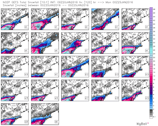
Another aspect about this set-up that makes it interesting to forecast, It appears like this storm will have a sharp cut off between heavy/crippling snow(2-3 feet) and plowable snow (a few inches). With another sharp line from plowable snow to little/nothing.
Forecast Details:
Tonight: Winds diminish a bit. But remaining breezy. Low: 12-18.
Wednesday: Mostly sunny, not as cold but still a bit breezy at times. High: 30-35.
Thursday: Cold despite plenty of sunshine. Breezy. High: 30-35.
Friday: Increasing clouds. High: Low-30s.
Saturday: Snow & gusty winds possible. But the exact impact on a brewing nor’easter remains uncertain. High: Mid-upper 20s.
 |
| The latest run of the GEFS showing the wide spread in possible solutions from a big storm to nothing! Image: Weatherbell |

No comments:
Post a Comment