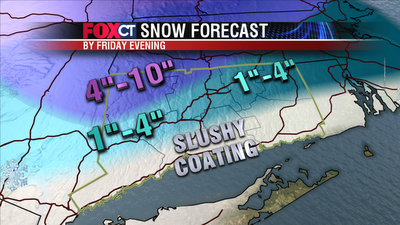
Clouds will thicken up tonight with a few sprinkles and flurries possible. Temperatures will drop into the upper 20s to low 30s. A storm tracking south of Connecticut will provide mostly cloudy skies on Thursday with a few scattered rain or snow showers. The morning commute tomorrow will be fine.
Late this afternoon/tonight showers will become more numerous and steady as a nor’easter sets it sights on Connecticut. Rain will mix in and change over to snow for a while tonight before changing back to heavy wind-driven rain leading into Friday morning. Some areas northwest of Hartford could stay as wet snow most of the storm. The morning commute will be a soaker (slippery in hills) with the whole storm coming to an end Friday afternoon and evening. April snow storms are tricky! The ground is warm from the 50 degree temperatures we experienced today. So snow will melt much easier on pavement. Also, snow accumulations Thursday night could get washed away on Friday as most of the state changes back to rain.
If the storm passes over Cape Cod, the state will see anywhere from a coating to 10” of snow statewide with some areas in central Massachusetts hitting the jackpot with a foot of snow. With this track the shoreline gets a slushy coating of snow with 1”-4” for the majority of Connecticut. Far northern Hartford County and northwestern Litchfield County will get the higher amounts with 4”-10” possible.
A shift in track to the east would mean that more cold air, more snow mixing in and higher accumulations. A shift to the west means that more warm air and lower accumulations. There is a lot of uncertainty regarding Thursday night – Friday so please make sure you check back for updates!

1 comment:
This is such a great site! I like the way you set this up! Great content! Thanks for sharing this!...Daniel
Post a Comment