
Friday, May 1, 2015
Fradiani Fever!
About 2 mins before my weathercast on Thursday, I was informed that Connecticut's American Idol Nick Fradiani would be joining me to do the weather. WHAT!? I quickly jumped into my show timeline and started deleting graphics. I didn't think Nick wanted to show computer models or surface maps. We didn't have any plan going into the weathercast and we didn't need one. Nick was such a down to earth guy and he really knows how to roll with the punches. We're all rooting for you Nick! (Especially me because I don't want you to take my job.)
Milder May
 Right on cue, a warm up arrives for the first weekend of
May! With a southerly wind, the shoreline will be cooler than inland areas for
the next several days. There is also a chance for an isolated shower both days
this weekend. But most towns will stay dry with temperatures climbing through
the 60s on Saturday and 70s on Sunday! The warm up peaks on Monday with high
temperatures approaching 80 degrees. Showers return on Tuesday followed by
cooler temperatures for the rest of next week.
Right on cue, a warm up arrives for the first weekend of
May! With a southerly wind, the shoreline will be cooler than inland areas for
the next several days. There is also a chance for an isolated shower both days
this weekend. But most towns will stay dry with temperatures climbing through
the 60s on Saturday and 70s on Sunday! The warm up peaks on Monday with high
temperatures approaching 80 degrees. Showers return on Tuesday followed by
cooler temperatures for the rest of next week.
Tonight: Partly
cloudy. Low: 40s.
Tomorrow: Partly cloudy,
milder. Chance for an isolated afternoon shower. High: low 60s inland, mid 60s to around 70
degrees for the shoreline.
Sunday: Mostly sunny and warm with the chance for an isolated pop up shower in the afternoon. High: low to mid 70s inland, near 70 for the shoreline.
Sunday: Mostly sunny and warm with the chance for an isolated pop up shower in the afternoon. High: low to mid 70s inland, near 70 for the shoreline.
Monday: Abundant
sunshine, warm. High: mid 70s to around 80 degrees.
Tuesday: A mix of
clouds and sun with showers developing. High: low to middle 70s.
Wednesday: Partly
cloudy, not as warm. High: upper 60s to lower 70s.
Friday, April 24, 2015
WarmER But Not Warm This Weekend
 The weather will improve this weekend (although that’s not
saying much after the last few days). Grab
a winter jacket early Saturday morning with freezing cold. Temperatures will rebound, topping out near
60 in the afternoon with more sunshine than recent days. A gusty northwest wind
will continue Saturday. While similar
temps are likely on Sunday, at least the wind will finally diminish. Clouds will thicken up throughout the day
with the chance for an isolated afternoon shower.
The weather will improve this weekend (although that’s not
saying much after the last few days). Grab
a winter jacket early Saturday morning with freezing cold. Temperatures will rebound, topping out near
60 in the afternoon with more sunshine than recent days. A gusty northwest wind
will continue Saturday. While similar
temps are likely on Sunday, at least the wind will finally diminish. Clouds will thicken up throughout the day
with the chance for an isolated afternoon shower.
A FREEZE WARNING IS
IN EFFECT TONIGHT. PROTECT ALL EARLY
SEASON PLANTS BY BRINGING THEM INSIDE OR COVERING THEM WITH A LIGHT BLANKET.
 Tonight: Slow
clearing, breezy, COLD. Low: Upper 20s to mid 30s.
Tonight: Slow
clearing, breezy, COLD. Low: Upper 20s to mid 30s.
Tomorrow: Mostly
sunny, breezy, not as cold as recent days. High: mid 50s to around 60.
Northwest wind at 5 to 15 mph.
Sunday: Increasing
clouds, chance for an isolated afternoon shower. High: upper 50s to low 60s.
Monday: Mostly
cloudy with showers developing. High: upper 50s.
Tuesday: Mostly cloudy with showers likely. High: low 60s. Some clearing late.
Wednesday: Sunshine with increasing afternoon clouds, warm! High: mid 60s to around 70 degrees.

Tuesday, April 21, 2015
Cooler Days Ahead!
 |
| Showers Wednesday afternoon |
A cold front will move through the area Wednesday afternoon. That front will bring us a round of rain, some heavy, followed by cooler weather Thursday and beyond! Where's the warmth? Well our weather pattern will stall thanks to a traffic backup in the atmosphere. You will notice a slow moving storm meandering through the great lakes for the coming days. And until we can kick that low away, 50s will be the new normal!
Tonight: Partly
cloudy. Low: Low to mid 40s
Tomorrow: Sunshine fades behind increasing clouds,
showers developing in the afternoon. Some could be heavy. Breezy south wind at
10 to 20 mph, gusts up to 25 mph. High: low 60s.
Thursday: A mix
of sun and clouds, an isolated afternoon shower. High: lower to middle 50s.
Friday: Cool and dry
with lots of sunshine. High: low 50s.
Saturday: Sunny
to partly cloudy. High: mid to upper 50s.
Sunday: Mostly
sunny. High: upper 50s to around 60 degrees.
Friday, April 17, 2015
Warm & Windy Start To The Weekend
 There is an enhanced risk for brush fires on Saturday with a
combination of gusty winds and low humidity. Other than that, Saturday will
also be a great day to spend outside. Temperatures
will soar through the 70s and sunshine will mix with a few afternoon clouds. A
cold front will come through in the afternoon. Rain will most likely stay north
of Connecticut although there is a chance for an isolated shower. Sunday will
be noticeably cooler with high temperatures in the 60s inland, 50s for the
shoreline. Wet weather returns late Monday with a coastal storm. Rain could
come down heavy at times Monday night into Tuesday. Cooler, unsettled weather sticks around for
most of next week.
There is an enhanced risk for brush fires on Saturday with a
combination of gusty winds and low humidity. Other than that, Saturday will
also be a great day to spend outside. Temperatures
will soar through the 70s and sunshine will mix with a few afternoon clouds. A
cold front will come through in the afternoon. Rain will most likely stay north
of Connecticut although there is a chance for an isolated shower. Sunday will
be noticeably cooler with high temperatures in the 60s inland, 50s for the
shoreline. Wet weather returns late Monday with a coastal storm. Rain could
come down heavy at times Monday night into Tuesday. Cooler, unsettled weather sticks around for
most of next week.
Tonight:
Clearing. Low: 45-50.
 A FIRE WEATHER WATCH
IS IN EFFECT SATURDAY. THAT MEANS A
HIGHER RISK OF BRUSH FIRES TO FORM AND SPREAD WITH A COMBINATION OF DRY AIR,
MILD TEMPS AND GUSTY WINDS.
A FIRE WEATHER WATCH
IS IN EFFECT SATURDAY. THAT MEANS A
HIGHER RISK OF BRUSH FIRES TO FORM AND SPREAD WITH A COMBINATION OF DRY AIR,
MILD TEMPS AND GUSTY WINDS.
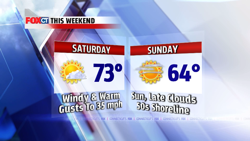
Tomorrow: Windy
and warm. A gusty northwest wind at 10-20 mph. Higher gusts up to 35 mph. High:
68-75.
Sunday: Sunshine
mixing with late day clouds. Cooler. High: 60-65 inland, 55-60 for the
shoreline.
Monday: Rain developing, some heavy at times late Monday or Monday night. Cooler. High: 48-53.
Tuesday: Chance
for some lingering morning showers. Clouds break for some late day sunshine.
High: 60-65.
Wednesday: A mix of
clouds and sun, cooler. High: 54-58.
Thursday, April 16, 2015
Showers Friday, Windy & Warm Saturday
 |
| Rainy start Fri AM |
 |
| Rain late Monday-Monday night |
Tomorrow: Morning
rain tapers for afternoon showers. Some late day clearing is possible. High:
60-65
Saturday: Sunny,
windy and warm. High: 68-74
Sunday: Sunny,
cooler, not as windy. High: 58-64
Monday: Rain
developing, some heavy at times late day and at night. High: 48-53
Wednesday, April 15, 2015
Sunny But Cooler
.png) Tonight: Clear,
cool. Low: 30-40.
Tonight: Clear,
cool. Low: 30-40.
Tomorrow: Sunny,
cooler with a light onshore breeze. High: temperatures in the low to mid 60s
inland, upper 50s for the shoreline.
Friday: Mostly
cloudy with a few showers, mainly in the morning. High: temperatures in the
lower to middle 60s.
Saturday: Mostly
sunny, breezy and mild. High: upper 60s
to low 70s.
Sunday: Sunshine
mixing with late day clouds. Cooler.
High: upper 50s to low 60s.
Monday: Rain
developing, some heavy at times late day and at night. High: 50s.
Friday, April 10, 2015
Cheers To The Weekend!
 A Dense Fog Advisory is in effect for the shoreline until 11
pm with visibility lower than ¼ mile. A
shower is possible early tonight followed by clearing with low temperatures
dropping through the 40s.
A Dense Fog Advisory is in effect for the shoreline until 11
pm with visibility lower than ¼ mile. A
shower is possible early tonight followed by clearing with low temperatures
dropping through the 40s.
After several days of chilly, cloudy and wet weather,
improvement arrives just in time for the weekend! Saturday will be partly to
mostly sunny and dry (finally). Winds will be blustery, blowing out of the
northwest at 15 to 25 miles an hour. That breeze will add a little chill to the
air, with high temperatures in the mid to upper 50s. Sunday is the pick of the
weekend with sunshine, less wind and temperatures soaring through the 60s. The
milder air will stick around through next week.
Tonight: Early
fog and showers followed by clearing. Lows: 40s.
Tomorrow: Partly
to mostly sunny and finally dry! Breezy
northwest wind at 15 to 25 miles an hour. High: mid to upper 50s.
Sunday: Sunny and
warm. High: mid 60s inland, near 60 for
the shoreline.
Monday: Warm with
lots of sunshine. High: mid 60s to around 70 degrees.
Tuesday: Rain
ending midday followed by some clearing. High: middle 60s inland, low 60s for
the shoreline.
Wednesday: Sunny,
a bit cooler. High: upper 50s to low 60s.
Tuesday, April 7, 2015
Icy Conditions Possible Wednesday Night
.png) Cooler air marches in on Wednesday with high temperatures
struggling to reach 40 degrees, ouch!
While most of the day will be dry, keep an umbrella handy with the
chance for a passing shower. The big
concern will be after the evening commute Wednesday night with a round of sleet
and freezing rain possible for parts of inland Connecticut. The morning drive
on Thursday could be slippery in spots.
Thursday is another cloudy, cool and damp day. Milder air moves in Friday into this weekend.
Cooler air marches in on Wednesday with high temperatures
struggling to reach 40 degrees, ouch!
While most of the day will be dry, keep an umbrella handy with the
chance for a passing shower. The big
concern will be after the evening commute Wednesday night with a round of sleet
and freezing rain possible for parts of inland Connecticut. The morning drive
on Thursday could be slippery in spots.
Thursday is another cloudy, cool and damp day. Milder air moves in Friday into this weekend.
Tonight: Cloudy
with areas of fog, drizzle and showers. Low: mid to upper 30s.
Wednesday: Mostly cloudy, cooler with scattered showers and areas of drizzle. Breezy northeast wind at 10 to 20 miles an hour. High: lower 40s.
Wednesday: Mostly cloudy, cooler with scattered showers and areas of drizzle. Breezy northeast wind at 10 to 20 miles an hour. High: lower 40s.
Thursday: Chance
for early morning sleet or freezing rain. Otherwise, cloudy with occasional
showers. High: lower to middle 40s.
Friday: Mostly
cloudy, milder with scattered showers. High: middle 50s to around 60 degrees.
Saturday: Finally
dry and pleasant! High: mid to upper
50s.
Sunday: Sunny,
dry and mild. High: around 60 degrees.
Monday, April 6, 2015
It's All Downhill From Here...Sorry
 Soak up that sun! It's all downhill from here. Lots of clouds the rest of the week with showery periods and below average temperatures. Hey...at least the weekend looks promising.
Tonight: Increasing clouds. Low: Low to mid 40s inland, upper 40s for the shoreline.
Tomorrow: Mostly
cloudy, cooler with scattered showers.
High: around 50 degrees.
Wednesday: Cloudy
and chilly with scattered showers and areas of drizzle. High: lower to middle
40s.
Thursday: Mostly
cloudy and chilly with the chance for a few showers. High: lower 40s.
Friday: Mostly
cloudy, milder with scattered showers. High: low to mid 60s.
Saturday: Sunshine
returns, milder. High: upper 50s for the shoreline, lower 60s inland.
Subscribe to:
Posts (Atom)