THANKS FOR VISITING!

I'm an Emmy Award Winning meteorologist at Fox 61 in Hartford. For the latest forecast updates (and fun stuff too, like food and family pics), please follow me on Facebook, twitter and instagram. I look forward to interacting with you there!

LIKE ME ON FACEBOOK!

Tuesday, October 30, 2012

Sandy Brings Record Storm Surge & Damaging Winds

 Cosey Beach in East Haven from Hurricane Sandy, just a year after the area was devastated by Irene. Pic by Michael McAndrews, to see more visit CTNOW.com
I got to work at noon on Monday.  After spending nearly a week and a half tracking Sandy’s every move, it was finally time to see if the monstrous storm would behave as forecast.  I wanted to be wrong!

At noon Sandy was moving faster than the official National Hurricane Center track.  I wondered if that meant the winds would diminish earlier too.  At 4 PM there were only 100,000 outages (little compared to Irene). Wind gusts reached 65 miles an hour in Groton.  But inland gusts were unimpressive. The fast moving winds in the upper atmosphere were not mixing down to the ground.

Not yet…

As the center of the storm moved onto the New Jersey coast, a warm front followed. In two hours, the temperature climbed eight degrees in Hartford.  The dew point came up too. Squall lines in the feeder bands provided enough turbulence in the atmosphere to mix those higher winds to the surface. So our peak wind gusts did not occur until after Sandy made landfall!  Power outages increased exponentially.

The forecast for coastal flooding was dead on. But I don’t take credit for that.  Local meteorologists like myself rely on the National Weather Service’s storm surge predictions. Bridgeport set a new record storm tide of 13.3’, beating the 12.1’ storm tide during Irene and the record of 12.3’ set back in the Hurricane of 1938. Eastern Long Island sound faired a little better.  New London’s storm time was 8.04’.  This did not break the record of 10.6’ set in the Hurricane of ’38 or the flooding during Hurricane Donna in 1954.

The European model nailed this forecast...again.
Last week I was skeptical.  Can you blame me?  Sandy’s track was unprecedented.  An October hurricane in Connecticut?  These storms normally bend harmlessly out to sea! 1000 miles of tropical storm winds? A hurricane merging with the polar jet stream? Hurricanes don’t normally strengthen after moving into cooler water! If I was at the casino two weeks ago…I’d put all my money on Sandy being a bust.
But Sandy made history.

Millions are without power including 600,000+ people here in Connecticut
Winds gusted up to 76 mph in Bridgeport
The snow in West Virginia is being measured in FEET
Battery Park City (my home town) experienced record storm surge, flooding the subways

And Sandy isn't done yet....


Sunday, October 28, 2012

Conditions Heading Downhill Already

Winds are already gusting to 30 mph and Sandy is 450 miles away.  That's telling...

The primary concerns for this storm are damaging winds and coastal flooding.  Rain totals will not be any more than we see during a normal fall storm (1"-3"). But winds will gust higher than they did during Irene.  Widespread outages are likely, similar to the number of outages experienced during Irene.  Ugh. And coastal flooding will not only beat Irene, but some towns could experience record flooding.

Everyone keeps saying "this is a long duration event".  Yes.  Clouds, rain, and breezy conditions will stick around through Thursday or Friday.  But the duration of the most damaging wind gusts to 60+ mph will be from 2 PM-midnight on Monday.

Conditions will go downhill tonight and tomorrow.  Get to wherever you want to be for the night by noon tomorrow. At that time, gusts will already be up to 50 mph for the shoreline, 35 mph inland and increasing.  Peak winds inland could top 60-70 mph, 70-80 mph along the shore. After midnight, winds will decrease quickly.

Here are the forecast tidal departures:
Tonight: 2' - 3' above high tide
Tomorrow morning: (9 am-noon) 3' - 5' above high tide
Tomorrow night: 6'-11' above high tide, near or above record levels!

As I stated in my previous blog post, these numbers are higher than the flooding experienced during Irene!  Also... additional flooding is possible along rivers and tributaries that link up to the Long Island Sound all the way up to I-95.
I wish I had time to write more. Please check out the news at 10 tonight on WCCT and on FOX CT tonight after the game!

Saturday, October 27, 2012

Record Coastal Flooding Forecast As Sandy Nears


COASTAL FLOODING IS THE BIGGEST CONCERN!

The National Weather Service will not issue any hurricane warnings for Sandy.  Don't let your guard down. The storm may not officially be "tropical" by landfall Tuesday morning, but it will be every bit as powerful.  I worry this will only cause confusion. But it’s not my call to make. 
Flood Watches have been issued Inland, Coastal Flood Warnings &
High Surf Advisories for the shoreline. 
Sandy is likely to remain at or near hurricane strength during the next day or so before interacting with a strong trough and cold front moving into the eastern United States. As that happens the storm will actually strengthen (which is not something that normally happens).

TIMING: 
A few showers could sneak in Sunday night.  Conditions deteriorate on Monday with the heaviest rain and strongest winds Monday night into Tuesday morning. Gusty winds continue through Wednesday morning. Showers linger off and on into Thursday.  So this is a long duration event!

STORM SURGE:

Storm surge is the abnormal rise of water due to a storm. Storm tide is the water level rise due to storm surge plus astronomical tides. The forecast storm tide for Sandy is higher than Irene and forecast to exceed record levels!  Please follow evacuation orders if they are issued.

Bridgeport Storm tide for Irene: 12.08’, 4.44’ storm surge
Bridgeport forecast for Sandy: 14.18’, 6.88’ storm surge

New London Storm tide for Irene: 6.55’, 3.49’ storm surge
New London forecast for Sandy:8.11, 2.45’ storm surge

5-8 foot waves are possible for eastern facing portions of Long Island Sound.  Minor coastal flooding is possible with the evening high tide on Sunday. Widespread moderate flooding is likely on Monday morning.  And major coastal flooding is possible Monday night with the high tide cycle. Moderate to major coastal flooding will continue through Tuesday afternoon.

WINDS:
Winds will howl out of the northeast sustained 35-45 mph with gusts to 60 mph. Hurricane force wind gusts ~74 mph can’t be ruled out.  It all depends on where the center of Sandy tracks.  If Sandy nudges north, the stronger winds will follow.

Peak wind gusts during Irene were 58 mph in Bridgeport.  Inland, 44 mph in Windsor Locks.  That doesn’t sound impressive.  But those winds were enough to cause over 700,000 power outages!  No matter what track this storm takes, the large wind field could bring a similar number of outages.


THE TRACK:

           
Right now the National Hurricane Center track takes Sandy across the southern tip of New Jersey on Tuesday morning. The strongest winds will be to the north and west of the storm’s track, the heaviest rain will be to the southwest of the storm’s center. 

RAINFALL:
1"-3" of rain is expected with the storm with up to 4" in spots. I don’t think inland flooding will be a major issue like it was during Irene.  At least not here in New England.  The heaviest rain will stay to our southwest.  But as rain from northern New England flows downstream, some flooding is possible

Dan Amarante will be on FOX tonight with an update after the baseball game.  Geoff Fox and I will be starting team coverage on Sunday.  Be safe and stay up to date on the forecast as much as possible!

Sandy's Storm Surge

If the NHC track pans out, wind gusts inland will be similar to Irene (tropical storm force). Inland some of you will think Sandy isn't so bad. But prepare for several days without power anyway. However...The National Weather Service is expecting 4-6 foot storm surge. Irene was 3.5 - 5 feet. Not good for coastal communities that just finished cleaning up after Irene! A northerly shift in track could mean higher storm surge and hurricane force winds.  Keep up to date on the forecast into tomorrow just in case.

The NWS Taunton discussion has all the latest thoughts and it's well written.

Friday, October 26, 2012

CT Still In Sandy's Crosshairs

No matter what….
  • You have Saturday and most of Sunday to prepare
  • Sunday is ok.  Maybe just a shower or two late or at night
  • Weather deteriorates Monday
  • The worst wind and rain Monday night-Tuesday Morning
  • BUT this could be a long duration storm with strong winds lasting through Wednesday, rain/showers through Thursday or Friday
  • Coastal Flooding is pretty much a guarantee.  We’re just not sure to what degree yet. Prepare for moderate to severe.
  • NO SNOW FOR US HERE IN CT!  Maybe in West Virginia or Pennsylvania.  No "snowicane" as some have suggested.
  • This is not a normal tropical storm that weakens after moving into cooler water. This "hybrid" storm will be gaining steam (unique) after interacting with the northern branch of the jet stream. 
  • The storm will become asymmetric with heaviest rain west of the storms track, strongest winds and storm surge right of the storm’s track.
  • Sandy will continue to grow in size as will the radius of hurricane and tropical storm force winds (hundreds of miles from the storm's center)!

We are rooting for the National Hurricane Center track right now.  A track near Delaware Bay is probably the best case scenario for us with the heaviest rain and wind staying south of Connecticut.  Scattered power outages with tropical storm gusts are likely in this case.  Some inland flooding is possible along small streams and creeks.  Coastal flooding will still be moderate to major. But for inland areas, not destructive. The farther south the better!

One of the most trusted computer models called the European  model
or ECMWF. Those Europeans sure know how to forecast!
But many of our computer models have a track north of the official NHC track. The major American computer model that we trust, the GFS, has a track taking the storm into Sandy Hook, and New York Harbor. This would be devastating for New York City and New Jersey with historical storm surge.  For us, hurricane force gusts are possible with widespread power outages and major to potentially severe coastal flooding.  Inland flooding is likely too with the storm getting stuck on top of us through Thursday or Friday.

A major American model called the GFS

Great NWS Taunton Discussion

Check it out here

3AM Sandy Thoughts

Quick Sandy update. I think I'm delirious. 3:15 AM and my bed is calling me.   It's going to be a long few days.  Coastal flooding is my biggest concern. Wind and rain specifics will come with time when we narrow down a track.  If the track continues to shift south, this might just be a rain and wind storm inland.  Coastal areas may not get so lucky. We're certainly seeing a lot more agreement than yesterday....errr...Wednesday?  It's late. Goodnight, see you on the News at 4 with Geoff Fox.

Thursday, October 25, 2012

Someone In The Northeast Is Getting Nailed


Video update later tonight!  Sorry I haven’t posted in a while.  I didn’t forget about you!  I have just been so busy forecasting.

The threat of Sandy’s influence missing us completely is slim to none.  Connecticut will get rain and wind from the hurricane. But to what degree? Sandy could bring hurricane force winds, flooding rain and a storm surge that rivals Irene with widespread power outages. Or Connecticut could get conditions that resemble a normal nor’easter with heavy rain and gusty winds. All of that will depend on the track.  But someone in the northeast is getting nailed.

Interesting that both the american and european computer models have shifted the storm's landfall south around the NJ/DE coast. The exact track will change.  But at least we're starting to see SOME agreement!
The GFS computer model is slower and has landfall Tuesday morning

The European model has landfall on the NJ coast Monday night
Timing: The worst will come at some point Monday or Tuesday.  We think the National Hurricane Center Track looks too slow showing landfall midday Tuesday on the NJ coast. I think landfall Monday night is more likely (as per the European model).  If my forecast is correct, that means clouds move in Sunday with some showers developing late day or at night. No big deal.  Conditions go downhill Monday with rain and wind increasing and landfall possible Monday night. Tuesday is still cloudy, rainy and windy, but not as bad. 

Impacts: No matter what track the storm takes, coastal flooding will be the biggest issue and has the potential to be worst than what we experienced during Irene (track dependent).  Astronomical high tide occurs Monday around 11 AM and Midnight, peaking at 7.38 feet in Bridgeport. Add to that an easterly wind, piling water into the Long Island Sound. The more time we spend with winds out of the east, the bigger the flooding concern.  There is a chance coastal communities will be asked to evacuate.  So put that in the back of your mind now and make sure you’re prepared.  25 foot waves are possible for ocean facing beaches.  We won’t get that in the sound.

Sandy’s wind field is expected to remain quite large.  But hurricane force winds will be concentrated closer to the storm’s center.  If the center of the storm moves inland well to our south (seems to be the trend), the heaviest rain would likely stay south of us and we could avoid significant wind damage. Remember, during Irene winds gusts reached up to 58 mph on the shoreline, 44 mph inland.  That doesn’t sound impressive.  But those consistent winds were enough to cause thousands of power outages in this heavily forested state.

If the storm hits us head on, we could get hurricane force winds, widespread power outages and heavy rain/flooding.

Bottom line, now is the time to prepare for multiple days without power.  Put an emergency kit together.  You still have plenty of time Friday, Saturday and most of Sunday. Keep up to date on the forecast too.  Every day we get a better picture about how this storm is going to behave.

How should I prepare? Tips from the National Weather Service in Taunton, MA

Monday - Tuesday Sandy Will Have Significant Impacts Here In CT

I have been forecasting all morning.  It looks like Sandy will have significant impacts on our weather. The exact track will determine wind speeds, rainfall amounts and coastal flooding.  Monday-Tuesday is when things could get nasty. We have time to figure out the details.  Meanwhile, it couldn't hurt to start thinking about preparations.  We'll keep you posted.

Wednesday, October 24, 2012

5 PM Advisory For Sandy

The track has shifted a little to the left.  Not surprising!

Wednesday Thoughts On Sandy

My first "at home, pajama" update in over a year. About Sandy, of course! Yeah I'm still in my pajamas at 1:30 PM. I've been looking at my computer all morning, tracking Sandy! Rambo was sleeping so he couldn't make it. But a new guest star shows up at the end!

Tuesday, October 23, 2012

Model Mahem: Sandy's Forecast Is All Over The Place


Joe Furey called me this afternoon to have a forecast discussion.  That's never a good sign.  The European model has latched onto this idea of a massive storm targeting the northeast with damaging winds, torrential rain, flooding and storm surge (see below).  This is a low probability, high impact event. Meaning....it would be irresponsible to just "go with" the Euro right now.  But since the outcome could be so potentially devastating, we want to put this possibility in the back of our mind.

Other models are flip flopping on the idea.  Now about half of the GFS emsemble members are on board.  (See below)

The NAO is forecast to tank over the coming days. This would suggest very strong blocking.

This blocking pattern off the east coast is modeled on the 12Z European model below.  Look for the shape resembling the Greek letter omega. An "omega block" can cause a traffic back up in the atmosphere, preventing Sandy from heading out to sea.


If Sandy was forecast to hit CT in three days, I would be freaking out.  But we're a week away! The likelihood that the European model remains the same for the next 6 days is very small.  The timing of the storm needs to line up perfectly in order to phase with an incoming trough.  Otherwise, the trough pushes Sandy out to sea instead of absorbing the storm.

Climatology is important too. Generally tropical storms or hurricanes forming in the vicinity of Sandy take a track well offshore or into the Gulf of Mexico. Especially an October storm!

After the storm moves into the Bahamas (pretty much all the computer models agree on that), we will have the best idea of what will happen next.  At that point our models should begin to agree and we’ll be able to tell you to relax or get ready.

Monday, October 22, 2012

Another Halloween Storm?

Halloween storms conjure up images of snow....NOT tropical storms.  Social media is abuzz with rumors of a 'storm of the century' type scenario.  So it's time for someone to step in and calm the masses.  I hate hype.  Can you tell? So do my co workers. Geoff Fox and I have been busy calming people down all night.  He wrote parts of this blog post.

First, let me just say I think that it's days too early to talk about Sandy coming to Connecticut.  If this storm were to impact the state, it would not happen until early next week...7 to 10 days from now!  Our forecasting accuracy decreases dramatically that far out. That being said, I understand why Connecticut is on edge about this. Last year's Irene and October nor'easter freaked us out.  No one wants to go another week without power. 

Meet Sandy. 
The storm is stationary, spinning in the Caribbean 400 miles SW of Jamaica with winds of 40 mph. Sandy will move north into the Bahamas.  This is one thing the models can agree on. Further than that, the models are all over the place. Just look at all the different solutions from the GFS ensemble members below!

The European Model, among the most accurate with Irene, predicts landfall on Cape Cod next Wednesday evening. This would be devastating for the northeast with gusts to 60-80 mph, 4-6" of rain and storm surge. There is a sizable blocking pattern to the northeast which could act to block Sandy from moving out to sea. (Don't stop reading here.  Because right now this situation is highly unlikely)


The GFS model (a trusted American model) has the storm curve safely out to sea with a weaker blocking pattern.


Researchers at University of Wisconsin at Milwaukee have plotted the ten historical hurricanes with characteristics closest to Sandy. Climatology is a major factor in hurricanes, so this is a reasonable tool. None came close to Connecticut.

So which model is right?  Is it a direct hit, a miss, or something in between?  The answer is not "which model is the best".  What we need is... time.  I know, I know.  That's a boring answer.  This storm is only in the beginning stages of development and we still need to watch how it responds to land interaction with Cuba and the Bahamas.  This is also a slow moving storm.  That's important to note. The slower a tropical system moves, the poorer our ability to accurately forecast it.  Everything would need to line up or phase perfectly for the European solution to verify.

It's not impossible, but at this moment it's unlikely. Even tiny errors in the computer models will multiply over time... and 7-10 days is a long time.

So let me do the worrying for now. I'll keep you posted!

Sunday, October 21, 2012

Warming Up Again Late Week


Tomorrow is almost a carbon copy of today’s weather. A northwest breeze will gust up to 25 miles per hour. Sunshine will stick around for one more day with high temperatures in the mid 60s.  Clouds will increase Tuesday as a weak warm front approaches.  A few showers are possible late Tuesday into Wednesday. Behind the front, temperatures will warm up late week with temperatures approaching 70 degrees! 

Then things start to get interesting. We are closely watching the Caribbean for an area of disturbed weather that could threaten the east coast next weekend. I would get into more detail but I don’t want to scare you!

On20. A Food Snob's Heaven!

I watch Top Chef and Iron Chef. Not because I want to learn how to make bacon iced cream (I love bacon, but that’s just wrong). Instead, I like to drool over the beautiful creations and imagine I’m the one eating them. 

Well I finally found a place in Hartford where food is treated like an art form.  On20 is a hidden gem.  It’s a restaurant perched on the 20th floor of 20 State street.  They do lunch on weekdays and dinner on Friday. I go for lunch because it’s cheaper and easier to get a reservation. 

Make sure you go hungry. I usually order an app and a main course.  Then the chef brings out an array of amuse-bouches (free appetizers)! The food is beautiful, unique, adventurous and delicious. No one has to ‘pack their knives and go’.
Sugar pumpkin ravioli with parmesan cheese, butter and truffle sauce
with candied pecans
Pan fried skate wing over a romesco sauce
Salmon wrapped in parmesan cheese over kale in a mushroom sauce
Monk fish with lobster, pureed potatoes and brussel sprouts
Beet custard with carmelized onions and a parmesan marshmallow
Pork belly and french toast with carmelized apple flavored with strawberry
Bartlett pear with yuzu foam, elderflower sorbet and lychee

Tuesday, October 16, 2012

Rain On Friday


How much rain we get still up for debate.  No matter what, bring an umbrella to the High School football games Friday night. The NAM and GFS (two of our favorite american models) have half an inch to an inch of rain (max).  The Euro is slower with a full fledged rainstorm and 1"-2"! (See below).


I'm more inclined to agree with the Euro at this point due to the slow nature of cut off lows.  The storm will be "cut off" from the jet stream so it's not in any hurry to move out.  On Thursday the storm will spin over the upper midwest.  By Friday the storm crawls over the Great Lakes region.  And it will take until Saturday before the low kicks up into eastern Canada.Right now the HPC seems to be in agreement with 1"-2" rainfall estimates for Friday.
                                        

Monday, October 15, 2012

A Roller Coaster, Baby Baby


The last few weeks have featured fast moving weather patterns.  This weekend began frigid with record cold and today will be warm with highs climbing into the 70s!  This week, expect another rollercoaster ride.  Clouds will lower and thicken up today as a cold front approaches.  Showers will develop in the afternoon and evening with a few rumbles of thunder possible.  Behind the front tomorrow will turn cooler and breezy with partly cloudy skies.  Temperatures warm up (again) later this week.

ING Hartford Marathon


Interviewing Joe the Cup at the ING Hartford Marathon!  He can't talk.  I talk too much.  We were a perfect team. Congrats to all the winners...ESPECIALLY our very own Joe Furey who finished his first half marathon!  WHAT A TRANSFORMATION! We're so proud of you.

Wednesday, October 10, 2012

Meet Ryan!

He is my best friend's son....so Ryan is my son too. Is he gorgeous or what? Have you ever seen such a big five month old?

Monday, October 8, 2012

Why Isn't It Raining?

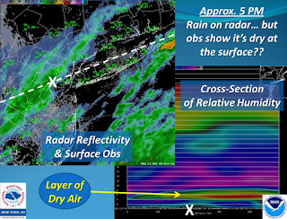
Geek Alert courtesy of the National Weather Service in NY:

If you happen to be looking at a radar image this evening, you'll see it picking up rain across a good portion of the area. However, until recently, many sites (with rain overhead according to radar) were indicating no rain.

What's going on here?


A vertical profile of relative humidity values indicates why: A layer of dry air around 5000 ft (yellows and reds) is causing most of the rain to evaporate before reaching the ground. For reference, the white X's are in the same location on each image.

 Slowly this layer should diminish, however, and allow most locations to see rain this evening and tonight.

Sunday, October 7, 2012

Fall Chill All Week


A fall chill will remain in place all week. If you want to see high temperatures in the 70s, head south. We’ll be trapped in the 60s for the foreseeable future.

Rain will taper off after midnight with some clearing towards daybreak. Low temperatures will tumble into the upper 30s to low 40s.

High pressure keeps the weather dry tomorrow for Columbus Day. But some high clouds will mix in with the sunshine as the day progresses. Those clouds will become lower and thicker tomorrow night with a weak area of low pressure grazing us from the south. A few showers are possible late tomorrow night into Tuesday morning. Tuesday afternoon will feature partial clearing. But clouds will increase again on Wednesday with the chance for more showers in the afternoon as a strong cold front moves through. Sun returns for the end of the week, starting on Thursday, lasting right through the Hartford Marathon on Saturday.  But it looks chilly for the marathon with temps starting in the low 40s! I'll need a winter jacket for our live coverage!

Thursday, October 4, 2012

Dear Sun: We Missed You. Love, Rachel

This is the grand finale.  One more round of rain tonight will get followed by relief from this soggy and gray weather pattern.  Some of the showers contain locally heavy downpours with rainfall rates approaching an inch per hour. The National Weather Service has issued a Flood Advisory for Hartford and Tolland Counties until 8:00 PM with the chance for some minor poor drainage flooding. Behind the rain, skies will clear and the humidity will drop. Patchy dense fog is possible again tonight with temperatures dropping through the 50s.

Then…hello sunshine!  We need a day like tomorrow to preserve our sanity. Early fog will break for sun and temperatures will soar up to 80 degrees inland. #LastBeachDay2012? Enjoy because the weather will start to head downhill Saturday. The morning isn't too bad with some sun to start. But clouds will increase with the chance for a shower in the afternoon as another cold front approaches.  High temperatures will climb into the low 70s. Most of the day looks dry so there is no need to cancel your outdoor plans.  But Sunday is a different story.  The second half of the weekend looks like a wash-out with a period of cold rain. There is a chance the rain holds off until the afternoon. Sun returns Columbus Day!

First frost in spots early next week?

Tuesday, October 2, 2012

The Weather Channel Starts Naming Winter Storms

Ugh.  Two sets of fake storm names this winter? I cringe thinking about the confusion this will cause.  Last year CL&P officials were calling the October Nor'easter Alfred, a name made up by WFSB. This year's "A" storm is Athena.  What will WFSB call it?  The government names tropical storms.  NOT winter storms.

To answer your question, no.  You'll never hear me talking about winter storm Gandolf unless I'm trying to be cute while watching Lord Of The Rings.  And Draco? I can't say the name without conjuring up an image of quidditch.

What is the criteria for naming these storms?  Who gives The Weather Channel the right to name them? Thoughts, anyone?

For a laugh check out this list of rejected winter storm names that are lighting up twitter

Getting Better (Not Hard After Today)


Rain will taper to scattered showers tonight with temperatures remaining in the upper 50s to low 60s.

Clouds, drizzle and fog will greet you tomorrow morning. At least temperatures will warm up, climbing into the low to mid 70s in the afternoon under mostly cloudy skies.  The humidity will rise too!  Although a few showers will pop up, most of the day will stay dry. Thursday is similar, remaining mostly cloudy, mild and muggy with a passing shower. Friday is by far the best day of the week with sunshine and summer warmth.  Clouds increase Saturday with a late day shower. Sunday could be wet as a potent cold front swings through.  Chilly fall air arrives behind the front for next week with daytime highs in the 50s and low in the 30s and 40s!

Monday, October 1, 2012

Bye Bye Sun, Hello October Warm Up!


We lose the sun tomorrow with another damp pattern setting up.  But the next few days will not be raw and chilly like last weekend. Instead, the showers are accompanied by a warming trend.  
Tonight temperatures will remain in the 50s with clouds lowering and thickening up. Tomorrow will be mostly cloudy with a passing shower, mainly in the afternoon.  Highs: Low 70s.

A warm front will boost the humidity on Wednesday with the chance for a shower.  But just like tomorrow, most of the day stays dry. Highs: mid 70s.

Then get ready for a touch of late summer warmth on Thursday with high temperatures approaching 80 degrees! The warmth doesn’t last.  A weak cold front knocks the temp back down into the 70s on Friday.  Then a stronger front over the weekend will bring us back to autumn reality with 60s by the end of the weekend into early next week.

Instagram @RachelFrankCT