

Wednesday, February 29, 2012
Snow Totals
This is how much snow already fell across the state! You can compare it to the snow forecast from the blog posts below. The milder air and a southeast wind caused mainly rain along the shoreline with very little sleet mixing in. Above freezing temperatures helped melt a lot of the snow on contact with paved surfaces. The exception was Litchfield County and some of our higher elevation areas where roads were snow covered (temps fell below freezing there). State Police say they responded to 100's of minor accidents during the storm.

The Worst Is Over, But We're Not Done Yet
2”-5” have already accumulated around and north of the I-84 corridor with a slushy coating to an inch or two in southern Connecticut. Most of the accumulating snow is over. A lull in the action is occurring right now with a light wintry mix of sleet and rain.
But another round of heavier rain/sleet/snow will move back in around or after midnight. Since milder air has already moved into the upper levels of the atmosphere, most additional precipitation will be sleet, rain or freezing rain. But if precipitation comes down heavy enough we may end up switching back to snow for a little while. An additional coating to an inch or two is possible overnight.
As our first storm fades, another coastal low will intensify tomorrow. This will bring northern New England another batch of heavy snow. But we’ll be on the southern fringe of precipitation with periods of snow, sleet and rain. Another coating of snow is possible, with an additional 1”-2” in northern Connecticut. This could cause more travel issues for the morning and evening commutes tomorrow. I wouldn't count on school delays or early dismissals this time around.
Here are some snowfall totals:

Tuesday, February 28, 2012
Snow Forecast Map For Wednesday
 The shoreline will start mixing with rain first, holding back snow accumulations. Most of inland Connecticut will get 2"-5" of snow. Along the Massachusettes border, mixing will take longer with 6" possible in far northern Litchfield, Tolland and Windham Counties. North of the CT border, up to 10"!
Timing: Wednesday morning will be dry for the commute with snow breaking out in the afternoon everywhere, continuing into the evening commute. Snow will change to rain along the shoreline Wednesday in the late afternoon or evening. Snow will change to a wintry mix of sleet and freezing rain inland Wednesday night. Then a lingering light wintry mix will continue into Thursday. A small additional accumulation is possible in northern Connecticut on Thursday.
Snow Update!
 I just had a chance to look at the morning model runs. A Winter Storm Watch is in effect for Wednesday (except for the immediate shoreline). Snow still looks like it starts during the afternoon. I see signs that we could get into mesoscale banding in parts of the state. I still think we start with snow then change to a wintry mix inland (sleet, freezing rain) with a change to rain on the immediate shoreline. Because we could get a decent thump of snow before we change to a mix, we could see more snow than I initially thought. 2"-5" or 3"-6" may be more appropriate. I'll be on the News at 4 with an update!
Update on Wednesday-Thursday
I’m waiting for this crazy NASCAR race to end. I’m starting to get loopy!! But I had a chance to check the 00Z model runs! My thinking has not changed. BUT I wanted to write a less technical discussion for the people who don’t like reading the geekiness from my previous blog post.
Timing:Wednesday morning will be dry for the commute with snow breaking out in the afternoon everywhere, continuing into the evening commute. Snow will change to rain along the shoreline Wednesday night around or after the commute. Snow will change to a wintry mix of sleet and freezing rain inland Wednesday night. Then a lingering light wintry mix will continue into Thursday.
Accumulations: Right now I’m thinking 1”-4. If the NAM is right (which I think is a hair too cold, 2”-5” will verify). Not a lot of snow but the arrival time will be less than ideal with roads deteriorating during the afternoon and evening.
Yesterday it looked like we could get additional snow on Thursday with a secondary coastal storm taking over. But the latest model runs show that storm takes too long to intensify. So that’s why I think we still see a light wintry mix but little or no accumulation on the back end. Thursday morning could be a little sloppy. But I’m more worried about Wednesday night.
Monday, February 27, 2012
Wintry Mess Wednesday & Thursday
Here are some of my thoughts regarding Wednesday-Thursday’s series of storms.
I am not worried about the morning commute on Wednesday. But Wednesday evening’s drive could be a mess! Clouds will lower and thicken during the morning on Wednesday. The timing has slowed down a little from yesterday. Snow will likely develop during the afternoon and it could be moderate to heavy for some during the drive home from work. As the evening progresses, a southwesterly flow in the mid levels of the atmosphere will cause warm air to invade. This will change snow over to sleet, freezing rain and rain. The GFS changes everyone to rain after 7 PM. The NAM (which deals better with cold air damming) keeps a wintry mix of sleet and freezing rain through the evening. Both solutions show 1”-3” or 2”-4” inches on the front side of the storm before the changeover. Either way I would avoid driving on Wednesday night!
Then we have to watch Thursday for another possible changeover to snow. This will be triggered by a second disturbance. But right now the models are trending towards a less developed and disorganized secondary storm. So even if we do get more snow it may just be another coating to an inch with a light wintry mix scattered throughout the day.
North of the Massachusetts pike the threat for big snow accumulations is greater where less mixing is expected. Obviously a small change in track and timing can alter the forecast. But everyone always asks me what I’m thinking. And these are my current thoughts! I’ll keep you posted!
Sunday, February 26, 2012
Mild Start Before Winter Returns
Tonight will be chilly with clear skies and temperatures plummeting into the teens and twenties. After a cold start to the day tomorrow, you can shed some layers in the afternoon. A southwest breeze at ten to twenty miles per hour will pump in mild air. Temperatures will once again crack the fifty degree mark! Morning sun will mix with afternoon clouds. Tuesday will be breezy and cooler with plenty of sunshine and temperatures returning to the forties. Then after a mild start to the week, winter returns! Prepare for a long duration storm on Wednesday and Thursday with a mix of snow, sleet and rain. The track of the storm will determine how much snow we get. This doesn’t look like a big snow maker. But no matter what happens it looks like two messy travel days.
Saturday, February 25, 2012
Watching Next Wednesday
We could see another nusiance snow event in the Wednesday-Thursday timeframe. Of course being five days from now, the computer models are arguing over a warmer/wetter (GFS) and a cooler/snowier (ECMWF) solution.
On the surface map as the storm approaches, high pressure will sit over eastern Canada. That's something we look for as meteorologists to help lock in the cold air. The GFS has one round of precip moving through on Wednesday as mainly rain. The Euro has two rounds of precip, one on Wednesday and the other on Thursday.
It's way too soon to nail down any solution. You know how much these things change in just a matter of hours, let alone 5 days. But you can bet I'll be watching this for you.
Check out the high in eastern Canada on the surface map taken from the 12Z GFS below.

Friday, February 24, 2012
1"-4" All The Way To The Shore. WOW!
Waking up to another busted forecast. Lovely. Here's what we got right: the timing of the storm, the impact (it would be fast moving but would hit during the commute). There would be slippery spots and school delays. Then we forecast conditions would improve as temperatures climbed above freezing. That was all true.
Here's what we got wrong. Snow accumulations were higher than expected, especially along the shoreline!! A few hours of mesoscale banding and heavy snow was enough to stick...even after a 50-60 degree day! Impressive! Sorry if my forecast ruined any part of your day. I saw some banding potential last night and gave it a quick mention. I guess I should have emphasized the uncertainty more. I never would have made a forecast map that had 4" down to the shoreline!
Map of snow totals
Map of snow totals
It's interesting to get feedback from viewers. I have received e-mails thanking me for getting the forecast right and others making fun of meteorologists. I hate the second kind.
Thursday, February 23, 2012
From Warm To White!? Friday Morning Snow.
From record warmth to snow? Bridgeport set a new daily record high temperature today. 60 degrees beat the old record of 57 set back in 1990.
So why are we talking about snow? This seems like a mistake. But with cold air moving in a mix of rain, wet snow and sleet will break overnight into early tomorrow. We are not expecting a lot of snow but the timing of this storm couldn’t be worse…hitting right during the morning commute. New model runs suggest moderate to possibly heavy snow inland for a few hours leading up to and during the commute. Even though the ground is warm and a lot of snow should melt when it hits the ground, if snow comes down heavy enough it could cause slippery spots and school delays.
I’m still working on snowfall accumulations. The HRRR (High Resolution Rapid Refresh) worries me with 4”-6”in the hills and 2”-4” for much of inland Connecticut. The NAM is in line with that but the Euro and GFS are a little warmer with a coating to 1” inland and 1”-3” in the hills. Because the models have overforecasted snow/cold so many times this winter, I’m leaning towards the GFS and Euro. I’ll keep looking at the models and I’ll update you tonight on the news at 10 with my final thoughts!!
Here's the HRRR for the snow lover's wishcast:

Tuesday, February 21, 2012
February Records
Warmest February?
Right now the warmest February on record occurred in 1998 and 1954 with an average temperature of 36.2 degrees. Our current average temp so far this month is 35.6 degeres, 6.7 degrees above average!
If the month ended today, this would be the 4th warmest on record. But we will probably climb in the rankings over the next few days with temps soaring through the 50s! We have a shot at breaking the record but cool temps this weekend might ruin our chance for the #1 spot.
Driest February?
We have only received 0.14” of precipitation so far this month! Wow! I knew it was dry but that stat even surprised me! The average precip in February (30 year mean 1971-2000) is 2.96”. If the month were to end today this would be the driest February on record! Of course, it doesn’t end today. We will add some rain to the bucket on Thursday and Friday. But not enough to make up for the dry weather so far. I think this February will place in the top 3.
Top Five Warmest Februarys (in degrees F)
Windsor Locks, CT
Since 1905
1) 36.2, ’98 and ‘54
2) 35.6, 1925
3) 35.3, 1981
4) 34.8, 1976
5) 34.7 in 1976
Top Five Driest Februarys
Windsor Locks, CT
Since 1905
1) 0.45”, 1987
2) 0.98”, 1980
3) 1.14”, 1968
4) 1.38”, 1997
5) 1.42”, 1978
Sunday, February 19, 2012
Sunny President's Day, Mild & Unsettled Midweek
Boy, we missed a big storm as an area of low pressure glides south of Connecticut tonight. The only effect from that storm will be some high clouds. Otherwise, temperatures will be chilly tonight, dropping into the 20s.
Grab your sunglasses on President’s Day with bright blue skies and plenty of sunshine. Winds will gust out of the north between 5 to 15 mph with temperatures in the low to mid 40s. Sunshine will stick around on Tuesday with the chance for showers Tuesday night as a small disturbance passes through. Wednesday through Friday look mild but unsettled at times with mostly cloudy skies and showers from time to time. Temperatures could crack the 50 degree mark a few times this week. There is no big outbreak of arctic air on the horizon.
Grab your sunglasses on President’s Day with bright blue skies and plenty of sunshine. Winds will gust out of the north between 5 to 15 mph with temperatures in the low to mid 40s. Sunshine will stick around on Tuesday with the chance for showers Tuesday night as a small disturbance passes through. Wednesday through Friday look mild but unsettled at times with mostly cloudy skies and showers from time to time. Temperatures could crack the 50 degree mark a few times this week. There is no big outbreak of arctic air on the horizon.
Thursday, February 16, 2012
No Big Storm Sunday
Yay! I am relieved this morning to find a model consensus for Sunday! The massive east coast storm will pass too far south and east, missing us here in Connecticut!
Right now an area of low pressure is beginning to form in the southwestern US. The storm will then scoot over the western Gulf of Mexico where it will blossom thanks to an influx of moisture.
Yesterday one of the computer models that we trust (GFS) showed the storm tracking over the sweet spot southeast of CT with up to 2 feet of snow! (See my blog post from yesterday.) The other models that we trust (like the Euro) showed a track that took the storm 100s of miles south of the state with no impact.
Today the computer models are in better agreement. The Euro has come north and the GFS has moved south. The result is something in the middle with a storm moving offshore between Virginia and North Carolina. The result is a storm JUST missing us here in CT or at worst grazing the shoreline with some flurries.
Sound familiar? The last storm on Saturday did the same thing, as have many storms this winter. That’s because the southern branch of the Jet Stream (which provides the moisture) and the northern branch of the Jet Stream (which provides the cold arctic air) are not coming together. They rarely do in La Nina years. In order to get a big coastal storm, like the snowmageddons we had last winter, we would need these Jet Streams to phase.
Meanwhile, a weak storm in the Ohio Valley will clip the area today with a period of rain. This storm is a weak one, and may drop as much as 0.25" of liquid precipitation by Friday morning before pulling away from the region. The Litchfield Hills and higher elevations have a chance to see some light snow and sleet instead.
High pressure will build into the region Friday and Saturday with plenty of sunshine and mild temperatures with highs reaching the upper 40's to near 50 and overnight lows in the 20's.
Here are the 12z (morning) runs of the Euro and GFS for midday Sunday. You can compare them to yesterday's model runs in the blog post below. What a difference!
The Euro midday Sunday

The GFS midday Sunday

Wednesday, February 15, 2012
Sunday Snowmageddon?
Not likely. Possible? Sure. But with the data I see right now, I'm betting against it.
The storm in question will be organizing in the western Gulf Coast area Friday night. We have confidence in that part of the forecast. But after that, our confidence level drops. Two major computer models show very different outcomes on Sunday.
One of the computer models that we trust the most (the GFS) is showing snowmagaddon with a foot or two of snow possible in Connecticut. Before the midday (18Z) model run, the GFS has been inconsistent, showing a snowstorm every other run. But now the model has pointed to a major nor’easter for two runs in a row.
On the other hand, the European consistently shows the same major storm gliding well southeast of Connecticut, exiting off the coast of the Carolinas with ZERO impact for us.
So far this winter the Euro has done a better job, especially with storms where the forecast has remained consistent through time.
The NAM isn’t great this far in advance. It only forecasts 84 hours out. But so far it also looks to side with a southern scenario with little or no impact here in Connecticut. I have also looked at about 10 other models (many that I don’t normally check). I just wanted to see if anything else was in the same ballpark as the GFS. Nope. Some are further north and west. But as far as a major CT storm, the GFS stands alone.
Other factors to consider…Even if this storm creams us in Connecticut, there is no big blocking high to help keep cold air in place. This works against the idea of a blockbuster snow storm and points to mixing, especially along the shoreline.
Here’s what the HPC has to say about the model spread:
“FARTHER EWD... THERE IS CONTINUED SPREAD WITH RESPECT TO THE HANDLING OF EJECTING SRN PLAINS/NRN MEXICO ENERGY AND NRN STREAM FLOW ACROSS THE NERN QUADRANT OF THE CONUS. THUS IMPORTANT DETAILS ARE YET TO BE RESOLVED FOR THE AREA OF LOW PRESSURE FCST TO TRACK FROM NEAR THE GULF COAST INTO THE WRN ATLC. AMONG LATEST GUIDANCE THE 00Z GFS IS THE CLEAR EXTREME IN BEING FASTER WITH ITS SRN STREAM SHRTWV AND DEEP/SWD/CLOSED WITH ITS NRN STREAM ENERGY TO YIELD A VERY DEEP/NWD SFC SYSTEM. MINUS THE 00Z GFS THE REMAINING SFC LOW SPREAD IS STILL QUITE BROAD AS OF EARLY DAY 4 SUN WITH ONE OR MORE CENTERS POSSIBLE IN AN AREA FROM THE SERN CONUS TO OFFSHORE THE CNTRL-SRN MID ATLC COAST. THE 00Z ECMWF WHICH SHOWS ITS BEST DEFINED SFC LOW NEAR THE SERN COAST EARLY SUN IS CLOSER TO HPC CONTINUITY OVER THE PAST DAY. THE 00Z CMC IS SLOWEST WITH ITS SERN CONUS SFC LOW. THE ECMWF MEAN IS MORE BALANCED BETWEEN THE SWRN/NERN SIDE OF THE SPREAD WHILE THE GEFS MEAN/06Z GFS AND TO SOME DEGREE 00Z UKMET EMPHASIZE A LEADING WAVE AS OF EARLY SUN. FOR NOW WILL LEAN CLOSER TO THE 00Z ECMWF TO MAINTAIN SOME CONTINUITY WITH ANY 12Z GUIDANCE TRENDS BEING INCORPORATED FOR THE FINAL FCST.”
12Z Euro for midday Sunday. No impact. Storm stays south of CT.
 12Z GFS for midday Sunday. Up to 2 feet of snow.
 Bottom line: I'm am betting against a snowstorm. We may not get a better handle on the forecast until Friday when the storm starts getting better organized and the models get better initialization. But I'm still nervous and watching the latest information very carefully.
Sunday, February 12, 2012
Bye Bye Cold!
The cold only lasted a couple of days but it's already on the way out! Look for temperatures to rebound this week.
Bundle up if you’re headed out this evening with low temperatures in the teens and a gusty breeze! Wind chills are in the single digits as I'm writing this (8 PM Sunday). Any early snow showers have diminished, revealing partly cloudy skies.
On Monday temperatuers will top out near 40 degrees with partly to mostly sunny skies. Winds will blow out of the west at 10-20 mph. Valentine’s Day will be equally as mild with mostly cloudy skies and the chance for a late flurry or rain shower. After that, our next chance for precipitation will be late Thursday into Friday morning with a wintry mix of rain and snow. There are no major outbreaks of arctic air in the near term. That doesn't bode well for snow lovers.
Saturday, February 11, 2012
Ski Connecticut!
 Skiers and snowboarders are bummed. Connecticut didn’t get a powder day. But don’t take it out on the local mountains! They’re ready for you with or without natural snow. Yesterday I went to Mohawk Mountain in Cornwall to snowboard with my college friend Ryan Hanrahan (also NBC meteorologist). He’s a skier. But we can forgive him for that. ;)
Weekdays at Mohawk it only costs $20 for a four hour pass to! Are you kidding me? That’s a better deal than the dollar menu at McDonalds!
I felt like a movie star who rented a mountain for the day to escape the paparazzi. It was empty. Every 20 chairs on the lift carried a person.
And how was the powder, you ask? PERFECT! Nicely groomed packed powder. I’m sure part of the reason the snow was so nice is because the mountain was empty. I started snowboarding last year so ice can really ruin my day. I fall a lot, much to Ryan’s amusement. But there was no ice. The snow got a little wetter towards the end of the day but I didn’t mind it. With sunny skies and temps in the 40s, it felt like spring skiing! Ryan called it a bluebird day, whatever that means. I don’t have the lingo down yet.
Anyway, my point of writing you this is to tell you to give your state ski resorts a chance. They’re working hard to stay in business. This year is tough on them because everyone who wants to ski immediately heads north. But if you like the luxury of having a local mountain on a good snowy year, you have to help keep them in business on a crappy snow year like this one.
Check out some of the local mountains:
Mohawk Mountain – I’ve been twice and loved it both times! Yesterday we explored the whole mountain. Nice wide open trails for those like me who are afraid of trees.
Ski Sundown – Last year I went here the most, maybe 5-6 times! Great place to learn how to ski/snowboard. Great location. So if you wake up late like me, you can still get a full day in. They also have night skiing.
Mount Southington- I have never been here. But Sarah Grant, web producer at FOX CT likes it for the location and easy trails to help work on improving your skills. They also have night skiing.
Woodbury Ski Area – Never been! Let me know how it is!

Waking Up Cranky
People often ask me if I'm ever in a bad mood. On TV I'm described as perky, energetic, optimistic and upbeat.
Not today.
I slept late today. I knew I wasn't going to see any white on the ground when I woke up. My forecast on Thursday called for 2"-4". On Friday, 1"-3", Saturday at 2 AM a coating to 1". The storm had trouble organizing. The atmosphere was getting robbed by a much stronger area of lift and energy south of the coastal low. The storm is also further southeast bringing most of the significant snowfall to southeastern Massachusetts and Rhode Island.
I want you to know that this isn't an easy job. I punish myself when the forecast falls apart. I'll be cranky all day. I feel like I let you down. But I think in this case, I'm punishing myself for no good reason. I did everything I could. I gave my best forecast every step of the way. I spent hours analyzing computer models and having weather discussions with my colleagues Geoff Fox, Bob Cox (WTIC NewsTalk 1080), Joe Furey, Dan Amrante and even yesterday Ryan Hanrahan from channel 30 (we went to college together).
This is not a perfect science. But I still take a busted forecast personally.
2 AM Update
The late models are trending down furthur with just a few FLURRIES in western CT. I think the lower end of my previous range may be too high (I was saying 1"-3". Instead... a coating to an inch seems more likely at this point. Don't be shocked if you see a lot of sun tomorrow afternoon. I hate when the forecast changes this much. I'll be cranky all day tomorrow.
I'll also be sore all day tomorrow. I went snowboarding yesterday at Mohawk Mountain in Cornwall, CT. The powder was PERFECT for anyone who is wondering about the slopes here in Connecticut. Check it out for yoursef!
I'll also be sore all day tomorrow. I went snowboarding yesterday at Mohawk Mountain in Cornwall, CT. The powder was PERFECT for anyone who is wondering about the slopes here in Connecticut. Check it out for yoursef!
Friday, February 10, 2012
Just A Little Snow
In the winter without a winter, everyone has been hyping up the snow expected on Saturday. Unfortunately, we’re not getting enough to make the snow lovers happy.
The computer models have backed off on the idea of a moderate snow event. The developing coastal low will move too far south and east of CT. The storm will also have trouble getting its act together and will not intensify fast enough.
Minor snow accumulations are possible on the order of 1”-3”. Areas in southeastern and far eastern CT could see locally higher amounts up to 4”-5”. But that would be an exception!
The timing of this storm has also changed. Although the start time is similar (late tonight/early tomorrow before sunrise), the end time looks earlier with the storm winding down by mid afternoon. You might even see the sun before it sets tomorrow night. Roads will be slippery and snow covered at times. But it’s nothing your snow tires can’t handle. And the roads should be good to go for tomorrow night plans.
As the storm pulls away, winds will howl and temps will tumble! Get ready for an arctic blast on Sunday with temps staying in the 20s and win chills in the teens and single digits. The cold is here. But snow…not so much.
Geoff Fox and Dan Amarante are working hard for you tonight and tomorrow! You can catch their forecast updates tonight at 10 & 11 and tomorrow morning from 7-9 am on FOX!
Thursday, February 9, 2012
Finally Snow In The Forecast
Snow is in the forecast! This winter? Am I dreaming?
A front interacting with a coastal low will bring the chance for a plowable snow on Saturday. The front, diving down from Canada will be the leading edge of arctic air. Meanwhile a low pressure system is expected to develop off the coast of the Carolinas on Saturday morning. There are still some questions that need to be answered. How close does the low come to the coast and how fast will it move away? Will we see any mixing on the shoreline? Will this storm be cold enough and have the right ingredients for mesoscale banding?
My early call is 2"-4" for most of the state. If the low gets closer, there could be higher amounts in southern/eastern CT with some 4-6” amounts. We are right on the borderline of higher snowfall totals, which is why I’m so nervous One computer model, the NAM has KVPD (Providence, RI) getting a foot of snow! The others, have lower QPF and/or more mixing for RI/eastern MA. Just so you know, the Euro has been consistently showing 1”-3” for CT the past few days.
I have more confidence in the timing/impact of this storm. Snow arrives late Friday night (after 2 AM) and continues into Saturday afternoon. I never like to tell people to stay off the roads. That’s your choice. But I will tell you that roads will be snow covered and slippery during the day Saturday. As the storm pulls away, the winds will turn gusty and temps will tumble into the teen Saturday night (wind chills in the single digits). But roads should be plowed by Saturday night if you have plans.
One thought…Many of the models show a secondary low develop south of the coastal low. I wonder if that could and help steal energy and moisture away from us? Some of the 00Z model runs start coming in before the news starts at 10 PM. I hope that new data will bring more confidence in the forecast. I want to see less snow on the NAM. Not because I hate snow. But because it’s the outlier right now and I would love to see some models agree on the forecast!
Here’s a look at the GFS for Saturday afternoon. Notice the double barreled low with the bulk of precip staying offshore.
 The NAM has the same double barreled low but it’s closer to the shoreline bringing heavier precip onshore.
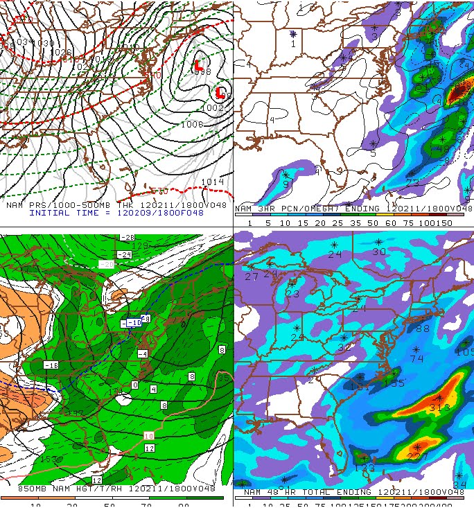
Sunday, February 5, 2012
Mild Start To The Week! All Is Quiet.
Our mild weather continues tomorrow with temperatures topping out near 50 degrees. You might feel a breeze at times with winds out of the southwest at 5 to 15 mph. High pressure will provide mostly sunny skies. A dry front will pass through the area early Tuesday. Although Tuesday will remain mild, temps will tumble into the 30s on Wednesday with the chance for a snow shower. Looking ahead, our weather remains quiet with most of the week’s temperatures staying above average.
Wednesday, February 1, 2012
Tale Of Two Januarys
Last January was the snowiest month on record. This year, they're giving roof rakes away for free. What a difference one year can make!


Record High Set In Bridgeport
Bridgeport set a new daily record high tempeature today of 62 degrees. The previous record was 57 degrees set in 1989. Temperatures rocketed 6 degrees between 3 and 4PM. Why the big jump in temps? No one else in the state climbed more than 1-2 degrees.
The wind was blowing out of the southwest all day long. That brings air over the cooler long island sound. At 3 PM the air temp was 56. Then the wind switched directions, out of the west at 4 PM. With a westerly wind, the air never travels over any water and never cools off! That's why the temperature jumped so suddenly.
Hartford did not break any records. The record of 67 degrees set back in 1989, still stands.
Subscribe to:
Posts (Atom)