As many of you know, FOX added an extra hour to the morning show, starting today. The AM News now extends from 4:30 AM - 10 AM. You could fly to Los Angeles in the amount of time we are on air every morning!
The last hour of show 9-10 AM is NOT your typical newscast. The show will be more of a conversation between Erika Arias and Rachel Lutzker about current events, health issues, style, cooking, even funny internet videos. No topic is off limits!
While Rachel Lutzker is on maternity leave (any minute now) I was given the opportunity to fill in on this new show. It was a very hard decision for me. Obviously, I knew I would have to give up the 10 PM newscast. I love working nights. I love who I work with. And most importantly I love the weather and presenting the weather each night to all of you!
But ultimately I decided that this would be a fun adventure for me! I will still be the meteorologist on the News at 4 (Monday-Friday). You know I could never cut weather out of my life! But for a few months I have the opportunity to try something I never pictured myself doing. This new show will be out of my comfort zone. But I’m excited to be able to show a little more of my personality.
Geoff Fox will be stepping in for me while I’m on the morning shift. My news director has promised me that my position on evenings is safe and I will resume my old shift when Rachel returns as a proud Mommy. So don’t worry about me! And I won’t abandon you…I’ll still be around for late night YouTube weather updates with Rambo.
Weather is still my #1 passion. I don’t want to be Oprah one day. But is there room for doing a little bit of everything? That seems to be the direction a lot of news organizations are taking these days, especially on the networks. Wish me luck, and I hope you get a chance to watch! Maybe you should give me a few weeks to warm up before you tune in. ;)

Monday, September 26, 2011
Sunday, September 25, 2011
Where’s fall?
Summer warmth and humidity are going strong with temperatures soaring into the 70s and 80s again on Monday under partly sunny skies. Tuesday will remain mild and muggy with more clouds around and the chance for a late day shower in parts of the state. There is a better chance for widespread rain on Wednesday and Thursday when a slow moving storm finally moves away! Humidity will fall throughout the day on Thursday with cooler, sunny and fall-like weather by Friday into the weekend!
Wednesday, September 21, 2011
Showers Tomorrow Through Tuesday!
The color grey is here to stay! A slow moving storm will bring unsettled weather today right through the middle of next week with waves of clouds and showers. Today feels like summer for the last day of the season! Temperatures will climb into the 70s with mostly cloudy skies and scattered showers. The humidity is creeping up too! Rain will become more steady and possibly heavy tomorrow with thunder possible. Although the weekend will not be a complete wash-out, keep the umbrella handy!
Sunday, September 18, 2011
5 Days Until Fall!
Although this week will start off feeling like autumn, a warming trend will allow summer weather to briefly return midweek. Monday remains dry and cooler than average with temperatures stuck in the 60s and partly to mostly sunny skies. Warmer air will start to invade Tuesday, triggering a few showers. Wednesday will be milder and increasingly humid with temperatures in the mid and upper 70s! Showers are likely at times both Thursday and Friday. The autumnal equinox occurs at 5:05 A.M. Friday!
Friday, September 16, 2011
Fall Foliage, Not As Pretty This Year? BOO.
Enjoying the foliage last year.

The chill in the air today reminds us that fall is just days away! You can already see a few colors on the trees. But could the heavy, tropical downpours this season stifle some of the fall colors? According to a Courant article by Edmond Mahony, yes!
"All that moisture is nurturing the growth of molds that wither tree leaves and threaten to dull the seasonal explosions of color throughout hardwood forests."Apparently you can already see the beginning signs of mold in the form of brown spots on the leaves.
And along the shoreline salt spray from Irene have already "withered" leaves close to the water, ending the leaf season early.
I love fall in England. I was born and raised in NYC where I passed 3-4 trees on the way to school every day (if I was lucky). I will still go on the hikes and visit the scenic overlooks this autumn with my camera in tow. I'm sure the colors will still be beautiful, even if they're not as spectacular as most years.
Thursday, September 15, 2011
Ch-Ch-Ch-Ch-Changes!
A strong cold front is giving summer the boot! This first cold blast may feel a bit more like winter when contrasted with Wednesday’s (record breaking! — at least in Bridgeport, Conn.) warm temperatures. Here are some graphics I was planning on showing tonight on-air. Don't tell my boss I'm unveiling them early for my loyal blog readers. :)
The last time daytime highs were in the 60s and lows were in the upper 30s/low 40s...May and June!

The coolest temps will invade Friday night into Saturday morning with cool Canadian high pressure building overhead. With clear skies and light winds, we will have the perfect ingredients for radiational cooling. Without the insulation that clouds provide, all our daytime warmth will escape up into the atmosphere and temps will drop like a rock! Lows: mid 30s to low 40s and patchy frost in some towns!!
 This is my forecast for high temps tomorrow, and the 48 hour temperature difference. Everyone will be 20 or more degrees cooler within the span of two days.
Lightning Show Last Night!!
Thanks to Bill Riordan for sending these cool lightning pics! These were taken in Hartford last night from the Park Place Towers! GORGEOUS! But the storms were LOUD for people who were trying to sleep.
The rapid expansion of heated air causes thunder. Since light travels faster than sound, the thunder is heard after the lightning. If you see lightning and hear thunder at the same time, that lightning is in your neighborhood.


The rapid expansion of heated air causes thunder. Since light travels faster than sound, the thunder is heard after the lightning. If you see lightning and hear thunder at the same time, that lightning is in your neighborhood.

Wednesday, September 14, 2011
Record Warmth For Bridgeport!
At 1:39 PM, Bridgeport set a new daily record high temperature of 86 degrees! This breaks the previous record of 85 set back in 1995.
At 5:00 PM the temp in Bridgeport is 81 degrees. For most of the day winds were blowing out the southwest over the cooler water of the LI sound. But a quick wind shift out of the west resulted in a brief spike in temperatures!
Enjoy the summer warmth. Because it's outta here! Tomorrow will be cooler with more clouds and a few showers. Then Friday, Saturday, Sunday will be cool and fall-like with highs in the 60s and low temperatures in the 40s! Hey, at least the sun will be out!
Friday night/Saturday morning will be the coldest with temps in the low 40s with some of the typical cool spots in Litchfield, Hartford and Tolland counties dopping into the upper 30s! Patchy frost is possible, but only for a few towns. Most of you will not see any.
Tuesday, September 13, 2011
The F Word (And I'm Not Talking About Fall)
10 days until the Autumnal equinox--Fall begins September 23rd at 5:05 A.M. Today is nice and summery. But later this week...a sign of what's ahead. A cold front Wed-Thu will knock temps on their butt.
Here is the WRF computer model showing temps for Thursday night/Friday morning. While we will easily drop into the 40s (green shading), some places in northern New England could fall into the 30s (blue color). F WORD ALERT...frost is possible for some in the northeast....maybe even right here in Litchfield County!
Here is the WRF computer model showing temps for Thursday night/Friday morning. While we will easily drop into the 40s (green shading), some places in northern New England could fall into the 30s (blue color). F WORD ALERT...frost is possible for some in the northeast....maybe even right here in Litchfield County!
 Here's another computer model, the GFS depicting the temperature (top two maps) and the 24 hour temperature change (lower two maps). Notice the temperature change is 15-20 degrees, ginormous (hmmm, spell check doesn't recognize this word)! Daytime highs will be in the 60s starting Thursday/Friday with overnight lows in the 40s. Is it time to bring out the fall clothing? No I would rather freeze. I feel like I just put them away!
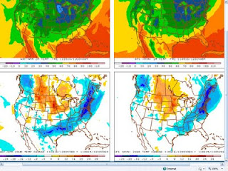
Thursday, September 8, 2011
Record River Flooding....AGAIN
The soil was saturated after heavy rain in August. Then Irene caused rivers and streams to flood all across the state. And just when you thought everything was back to normal...Lee came to pay us a visit. Sure, we only got Lee's "remnants". But Lee was the straw that broke the camel's back. The rivers were already swollen and this latest round of rain sent some rivers EVEN HIGHER than they were after Irene. I'm sure you have all seen this video of the University of Hartford Campus.

Housatonic River at Stevenson Dam: 7th Highest crest. Notice again the latest peak rivals river levels post Irene.
 The Pomperaug river at is already falling below flood stage after major flooding and the 4th highest crest on record. The latest round of flooding was a few feet short of river levels after Irene.
 For the latest river levels and historic crests go to the Advanced Hydrologic Prediction Service webpage.
The Housatonic River at Falls Village: 12.41', 5th Highest crest. Notice the water level now is greater than the peak crest after Irene (between August 29-31). And the water continues to rise.
Housatonic River at Stevenson Dam: 7th Highest crest. Notice again the latest peak rivals river levels post Irene.
The Pomperaug river at is already falling below flood stage after major flooding and the 4th highest crest on record. The latest round of flooding was a few feet short of river levels after Irene.For the latest river levels and historic crests go to the Advanced Hydrologic Prediction Service webpage.
Flooding Rain Last Night
Last night Bradley International Airport recorded 3.65" of rain! Rainfall rates were over an inch per hour for two hours. I have to admit the heavy rain last night wasn't in the forecast. I called for showers and a few heavy downpours but there was no hint of the flooding that followed. The computer models were blindsided, the radar was fairly quiet, even at 11 PM. Looking back, I didn't "miss" anything. But this is proof that there's a limit to what we do as meteorologists. We aren't always right. And yes, I'm OK with admitting that.
Here are rainfall totals over the past few days. Very impressive! This rain combined with rainfall from Irene and a wet end to August caused flooding for many rivers and streams across the state.


Tuesday, September 6, 2011
Labor Day Is Over...Is Summer Over Too?
Labor Day weekend is considered by many to be the unofficial end to summer, and this week the weather seems to agree! Temperatures stayed in the 60s today with periods of rain, making it feel like fall! Tonight rain will continue at varying rates. But I think the steady heavy rain ends by late tonight.
Wednesday and Thursday will also have a soggy fall feel. BUT the worst is over. The next two days will remain cloudy with scattered showers, drizzle and patchy fog. But I do not expect steady, heavy rain.
Katia’s track remains unchanged. She is still expected to pass between North Carolina and Bermuda, before making a sharp right hand turn out to sea. Katia will bring high waves and dangerous rip currents to ocean facing beaches. But Long Island will protect us from those effects here at Connecticut beaches.
Thursday, September 1, 2011
Irene's Aftermath: Pics
Downed trees, powerlines, river flooding, storm surge...WOW. While many of you got lucky with little or no damage, Irene has changed the lives of some people living in Connecticut. I took these pictures from CTNOW.com. Click here to see more.
 Milford ( Bettina Hansen ): A beachfront home was heavily damaged after Hurricane Irene ripped through the area Sunday, August 28, 2011 in Milford, Connecticut.
 Cosey Beach Damage ( Cloe Poisson, Hartford Courant / August 29, 2011 ): Shayna Weinstein gets a hug from her dad, Andy Weinstein, as they prepare to leave what's left of their summer cottage (at left) on Cosey Beach in East Haven, that was destroyed by Tropical Storm Irene on Sunday. The storm, which completely flattened the house, struck on Shayna's 16th birthday. "It's the worst birthday I've ever had," she said. The Weinsteins live in Woodbridge.
 Cosey Beach Damage ( Cloe Poisson, Hartford Courant / August 29, 2011 ): Piles of rubble are all that's left of a house along Cosey Beach in East Haven after Tropical Storm Irene barreled through the state on Sunday. About 20 homes were destroyed or severely damaged including this one in the center. The cottage at right, built in 1895, has been in the Auerbach family since 1943. The Auerbachs live in Woodbridge. The house is a total loss.
 Hurricane Irene ( Patrick Raycraft, Hartford Courant / August 28, 2011 ) Jason Jorge, 10, surveys the flooding of his home (at top of photograph) in Southbury today. "We were two weeks away from moving back in," says Jason's mother Joanne Jorge. The same river basin flooded in March of this year when Jason and his family was displaced.
 New Milford Housatonic (webstaffcourant) New Milford Housatonic Jim Tupko New Milford, CT
 Storm surge from Hurricane Irene in Bridgeport ( MARK MIRKO/HARTFORD COURANT / August 28, 2011 ) A storm surge from Hurricane Irene covers the boardwalk at the Water Street Dock in Bridgeport.


Downed trees and utility wires in Chester ( Patrick Raycraft/Hartford Courant / August 28, 2011 ) Downed trees and utility wires completely blocked Route 154 North in Chester.
Was Irene Hyped?
I'm stealing one of Geoff's blog entries now. One of his good friends, Bob Hart, a renowned expert in tropical meteorology and a North Branford native wrote an essay recapping the coverage of Irene on FOX CT. I obviously like the fact that he complements our forecasting. But even better...he recaps the storm, discusses the hype factor, and addresses Irene's forecasting challenges.
"First, I wholeheartedly agree with the replies here noting the quality of the forecasts by Geoff and Rachel. If this storm were to happen again, I would not ask that the forecasts be changed in any significant way for CT.
While several of those who received little impact from Irene (or those watching from afar, or the masochistic wanting damage) are claiming hype, those who truly were impacted in a serious way are generally not.
I was on the CT coast for Irene and visited a few towns, including that where I grew up (I still have family there). I’m willing to bet a large sum of money that if you asked those impacted by surge (Milford, Branford, Guilford, and beyond) – whether the storm was worse than Gloria – they would say yes.
In fact, my reading of the surge numbers in Bridgeport, New Haven, and elsewhere on CT at least are that they were comparable to category 2 hurricane estimates!
Was this due to the high tide and new moon? In part, yes – but only in part.
Can we forecast the timing of landfall to within 6 hours two days out to make that determination? Absolutely not.
In fact, Irene arrived many hours earlier than the two day forecast (when watches are issued). This is why it is important to consider the range of possibilities in a forecast, as there is an (unspoken) “cone” of uncertainty about intensity just as there is a well-communicated cone about track.
Yet, I suspect if you asked those at the Massachusetts border they would say they barely got tropical storm conditions, and they might be right (I haven’t seen much data since I was out of internet access until my Delta flight right now, ironically!).
Let’s pretend for a minute that we knew from the start that Irene would be a tropical storm when it crossed CT – let’s pretend that only tropical storm warnings were issued from central NJ northward. My bet, with a lot of money, is that the loss of life would have been greater, perhaps much.
A weakening major hurricane crossing as a tropical storm produces much different impacts than a tropical storm that is stable. These generally include storm size, the accumulation of wave growth and surge, as well as model performance. And yet the warnings cannot discriminate between these.
We are a spoiled society. I don’t think that most in NYC realize how much worse it could have been, how close they came. They should look at how far the surge went in CT and LI. Seawalls completely destroyed and pushed inland dozens to hundreds of feet. I saw it in CT.
No doubt those in low lying areas of NYC remember December 1992 when the subways flooded and the FDR and other major routes were covered in water. Many areas on coastal CT approached or exceeded that storm. I suspect those who lost their homes completely in CT and LI (out to sea, yes, there were several in CT and elsewhere where literally only a foundation was left) would gladly have traded their epic loss for a weekend of board games and wine with the family as the only “inconvenience”.
This is the problem with the categorization of hurricanes. The number is primarily associated with wind. Yet, the surge is not entirely (in fact, far less) explained by the wind. The rainfall is almost completely unrelated to the strength of the wind.
The surge in CT was equivalent to a typical category 2 (between Gloria’s surge and 1938’s record surge) while the wind was strong tropical storm (although the post-season analysis will determine that concretely). A moderate to even upper category 1 forecast landfall was exactly the right forecast two days before landfall, when watches were issued and evacuations considered, given the guidance.
And then there is a specific nature of the wind definition of category. The definition of the Saffir-Simpson category is the estimated strongest SUSTAINED wind (1-minute average) at 10-meter elevation anywhere in the storm at that time, assuming open exposure over land. Yes, anywhere in the storm. This means that 99.44% (thank you Ivory soap) is less than that maximum. And most places are much less given the structure of hurricanes.
In fact, almost by definition, the strongest wind in a hurricane is NEVER observed by people or their homes. So a true marginal category 1 hurricane in CT is quite likely to only produce tropical storm force sustained winds across the coastal population and in many well inland areas not even that.
And yet, while being a likely tropical storm in CT at the end, Irene produced a remarkable extent of 50-75mph gusts across a broader region than almost any prior tropical storm on record (well into RI) due to its unusual structure (topic for another day).
And that above tricky definition is the rub.
A colleague at NHC (Dr. Mike Brennan) forwarded some observations from Katrina (category 3 landfall). Do you realize that not a SINGLE official land-based station reported sustained hurricane force winds? Repeat, no official category 1 sustained winds in Katrina on land.
Sure, plenty of gusts – plenty – to hurricane force and even a few to category 2 or 3, but no sustained hurricane force winds.
Even at official marine sites, there was no reported sustained wind above category 1 (six sites reported hurricane force sustained winds, but none above 76kt). If a storm like Katrina which 1) was also huge, 2) so much more intense and 3) hitting an urban area, cannot produce a hurricane force sustained wind on land, we cannot expect the same in CT even if Irene was a category 1 hurricane– unless there is amazing chance.
That chance happened in Bridgeport with Gloria. Gloria produced a 64knot sustained wind in Bridgeport. It was the only sustained wind observed at an official station in CT. And it was by chance, given the track.
In the end, I think our definitions are flawed. We should not be defining a storm by the peak sustained wind intensity which is almost never truly observed. It is for this reason that perhaps millions in south Florida think they experienced category 5 winds, when perhaps a few hundred did (if that).
Finally, I have never seen a track forecast for a New England tropical cyclone as good as this one. NHC, the models they use as guidance, and the scientists who work extremely hard on their developments are to be commended. The actual track the storm took has only occurred a handful of times (perhaps a few fingerful, I won’t pick which fingers) since the 19th century. And while there was some uncertainty of track (over Philadelphia, over NYC, over Boston), it almost never was forecast to go out to sea 4-5 days out (and longer). This is astonishing.
Remember Floyd in 1999? The track was all over the place 4-5 days out. Hugo in 1989 was forecast to come up the coast originally!
Irene was a landmark event for track forecasting for New England, but we should not be spoiled by this. Don’t count on this confidence next time.
As Geoff mentioned, he slightly lowered the rain and wind forecasts Saturday night. It was the right move, and it was the correct forecast. It was the scientifically correct decision without jeopardizing preparation, since people had already prepared. It was a tough decision and not everyone made the same decision, but it was correct from a scientific perspective yet very difficult from a communication perspective.
As part of my classes, I require my students to forecast (and I forecast along with them as any meteorologist worth their salt will do, no matter what the alphabet soup at the end of their name says). I cannot do what Geoff and Rachel do, and I assure you that very few in the world can. Very few jobs in the world require you to be an expert on snowstorms, icestorms, floods, hurricanes, computers, and top-tier communication and improvisation. Oh, and a very thick skin at times. Although I imagine it is very rewarding in the net, I suspect you don’t want their job.
In light of all the above, the consequences at play, and having gone through Irene and having watched Geoff’s blog, and Geoff’s and Rachel’s forecasts for days, I applaud them. People and property were saved during this storm by their forecasts, and their very effective communication of those forecasts.
CT is very lucky to have Geoff back on the air. Now if only our schedules would cross paths so we can meet up for poker.
Bob Hart
Florida State University"
Did NOAA peg Hurricane Irene’s track four days out?
The National Oceanic and Atmospheric Administration (NOAA) has been promoting the fact it “nailed” Irene’s track four days out. Their home page features a satellite animation following the National Hurricane Center (NHC) track issued at 11 p.m. ET on Tuesday, August 23.
You have heard me say this before. Four days out, the average tropical forecast error is 200 miles. So that makes this forecast verification even more amazing!! Check out the video: NOAA Environmental Visualization Laboratory - NOAA Accurately Predicted Irene's Path 4 Days in Advance
You have heard me say this before. Four days out, the average tropical forecast error is 200 miles. So that makes this forecast verification even more amazing!! Check out the video: NOAA Environmental Visualization Laboratory - NOAA Accurately Predicted Irene's Path 4 Days in Advance
Subscribe to:
Posts (Atom)