THANKS FOR VISITING!

I'm an Emmy Award Winning meteorologist at Fox 61 in Hartford. For the latest forecast updates (and fun stuff too, like food and family pics), please follow me on Facebook, twitter and instagram. I look forward to interacting with you there!

LIKE ME ON FACEBOOK!

Tuesday, August 30, 2011

Irene's Impacts Are Over...Well...Almost


The Housatonic and Farmington rivers have already peaked and are receding. The Connecticut River is cresting right now in Hartford. But in Middletown the river will cresting up near major flood stage early tomorrow morning. The amount of flooding will mimic spring 2007. By this weekend all rivers will be back to normal! But don’t jump in the water yet, there is still a lot of debris floating around. Tonight will be comfortable for those who are still in the dark after Irene.

Temperatures will tumble into the 50s with low humidity. Tomorrow will be another nice day for cleanup efforts! High pressure will provide mostly sunny skies and temperatures will be a little milder than recent days, climbing into the low to mid 80s. Clouds will increase a bit on Thursday with the chance for a shower in spots as a weak cold front moves through. You will also notice the humidity increasing a little bit.

High pressure will build back into New England on Friday with temperatures staying in the 70s. Over Labor Day weekend you may have to dodge a few raindrops or a thunderstorm on Saturday and Monday. But neither day should be a “washout” for your outdoor plans. Also, we’re not expecting enough rain to agitate rivers again.

Irene Sights & Sounds

Connecticut River Rising; Flooding Expected In Middletown

Behind The Scenes Covering Irene


Sunday, August 28, 2011

Bye Bye Irene.

At least 25 homes in East Haven were completely destroyed, one person has died, others are missing and more than half the state is without power after Tropical Storm Irene tore through Connecticut.

Irene made landfall on the New Jersey shore and then on western Long Island this morning as a weak category 1 or a strong strong tropical storm (that's up for debate). The storm could've been much worse had it been just 20-40 miles further east of the coast of New Jersey. The increased time near land increased friction and took half the storm away from its source of energy, the water! The Euro was the big winner for this event. That computer model predicted this track from the very beginning. Of course it's easy to see that in hindsight.


Wind speeds were at the low end of our projections. Here are some of the top wind gusts during Irene. I find it impressive how the combination of gusty winds and a soaking wet ground uprooted so many trees and power lines! I had several trees laying in my parking lot when I woke up this morning. I'm one of the few cars that lucked out without a scratch.

During Hurricane Gloria 477,428 CL&P customers were without power. Irene left HALF of CL&P customers in the dark. As I'm writing this, 652,097 without electric! A historic storm response! Here is the link for the current CL&P outage map.

Rainfall amounts were higher in western Connecticut (as we expected, closer to the storm track).


The soil in Litchfield and Fairfield counties was already at saturation and the rainfall totals overwhelmed rivers and streams, some to historic levels (As noted below). While all of the rivers below have crested and are falling now, the Connecticut River is much larger and will continue to rise through Wednesday. Here is a link to river level forecasts.


Here is just one of many videos of river flooding across the state. Naugatuck River Webster Bank on Rubber Avenue


The average return time for a hurricane in Connecticut is 16 years. I hope that's true.

3"-7" Of Rain, 500,000+ Without Power From Irene

Irene has been downgraded to a tropical storm as the center moves into western Connecticut. The forward speed has increased to 23 mph (twice the speed Irene was yesterday). That's good for us! The track was slightly west of the official National Hurricane Center forecast.

Maximum sustained winds are 40 mph. The storm is transitioning into an extratropical storm (a cold core storm instead of a warm core storm). Although rain will end by mid afternoon, the wind will continue to howl as the storm pulls away. Wind direction will shift out of the northwest. The sun will probably come out before it sets tonight.

There's nothing more beautiful then the day after a hurricane with sinking, dry air and sunny skies.

Saturday, August 27, 2011

Irene Still On Track For CT Landfall

Irene is now a category one hurricane with sustained winds of 80 mph. The center of Irene is now moving away from North Carolina towards Virginia Beach. The National Hurricane Center track remains unchanged, taking the storm up the eastern coast of New Jersey, making landfall early in the afternoon near Stamford Connecticut as a weak category one hurricane. Even if Irene weakens into a strong tropical storm, her affect on us will remain the same.

Rain will become steadier and heavier as we move throughout the overnight hours. The heaviest rain will start around 2 AM with winds picking up around 5 AM. Damaging winds around Irene’s eyewall will begin at 10 AM with landfall on Fairfield County around 2 PM. Winds will begin to subside around 4 PM with rain moving out between 5 PM-9 PM.

Shoreline areas should prepare for hurricane force gusts around 74 mph, with tropical storm force gusts to 60 mph inland. The heaviest rain will fall in Western Connecticut where the ground is already saturated. This will cause flooding of streams, creeks and rivers. Typical flood prone areas and basements will likely flood. 4”-12” of rain will fall statewide with the lowest rainfall totals in southeastern Connecticut and the highest rainfall totals in Fairfield and Litchfield Counties.

High tide will occur between 9-11 AM around the same time Irene will provide the strongest winds. High tide combined with a long duration event will provide higher than usual storm surge. 4’-8’ storm surge is possible west of New Haven with 2’-4’ storm surge east of long island sound.

Isolated tornadoes are also possible as the storm approaches. When hurricanes make landfall winds at the ground level slow down while winds at the top of the storm keep their momentum and this can cause rotation that spawns tornadoes.
If the storm moves out fast enough you may even see the sun just before it sets tomorrow night.

Midnight Update On Irene

The audio is terrible because of the air conditioning. But that's what you get for trying to record video updates on your couch in your pajamas.

Friday, August 26, 2011

Hurricane Warnings CT Shoreline

Hurricane Watches for the Connecticut shoreline have been upgraded to Hurricane Warnings now with hurricane force winds likely in the next 36 hours.

The storm's inner core has weakened and it's possible that Irene falls just below hurricane strength before reaching southern New England. BUT the impacts will not be very different for us here in CT if the storm is a weak category 1 hurricane or a strong tropical storm.

Irene is still forecast to move slower than your typical tropical storm as she makes landfall which will produce extended periods of tropical storm/hurricane force winds.

The latest National Hurricane Center track is shifted only slightly so that the storm makes landfall over Long Island, followed by another landfall over Norwalk. This would put the heaviest rain 6"-12" in western Connecticut (Fairfield, Litchfield, Western Hartford and New haven Counties), with 3"-6" everywhere else.

Conversely, winds will be the strongest east of the storm track in southern Middlesex, New Haven and all of New London County with gusts to 90 mph. Although gusts could also reach hurricane force in central Connecticut but will remain slightly weaker, up to 80 mph.

Storm surge is still a major concern and is likely to be worse than Gloria with the storm arriving at the same time as the highest tidal departure of the month.

Irene 11 AM Update

Irene has once again decreased in intensity caused by wind shear! During the 11 AM update, Irene has sustained winds of 105 mph making her a category 2 hurricane. This decrease in wind speed is good news for North Carolina. But the downgrade has no impact on us here in Connecticut. The forecast remains on track.

Given the storm's structure and envoronmental factors, little change in strength is expected as the storm heads towards North Carolina.

After passing North Carolina, southwesterly wind shear and cooler ocean temperatures should result in a gradual weakening of Irene.


But Irene is still expected to remain a major hurricane as she heads into the northeast with damaging winds, storm surge flooding and extremely heavy rain from eastern North Carolina all the way to New Enlgland.

Irene Forecast On Track For Connecticut


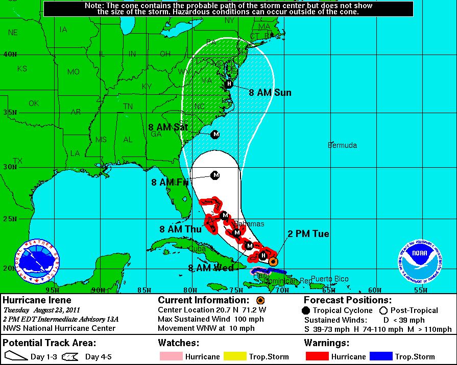
Alright here we go. Irene is taking a very similar track to Gloria. Hurricane Watches are in effect for the southern four counties of the state with Tropical Storm Watches in effect for the northern half of Connecticut. Irene will take a very similar track to Hurricane Gloria. Prepare for similar damage. Storm surge could be even worse.

The track from the National Hurricane Center has shifted east again which means less land interaction from the New Jersey coast and a stronger storm for us. This could really turn into a worst case scenario. Could this track shift again? YES! I could be wrong and this is the one case I hope I am! But until I see strong evidence of this storm moving away, I have to prepare us for the most likely scenario.

Forecasting these storms is about half science and half experience. I know my science but I'm new to Connecticut. I have been consulting with Joe Furey, Geoff Fox and Ryan Hanrahan (from NBC30, we went to college together ,he's a genius). I don't feel it's right to post this blog entry without giving those people a shout out.

Timing: Showers from the outer rain bands of Irene will begin to affect us on Saturday. But the timing of the storm is a little faster than we initially anticipated. Tropical Storm Force winds will begin while you’re sleeping on Saturday night. Hurricane force winds and torrential rain Sunday. Prepare for an all day event. But things should be winding down on Sunday night.

Rainfall amounts: 5”-12” of rain with the heaviest amounts to the left of the storm’s track. That means location will make all the difference in terms of rainfall totals. If the storm cuts right up through the center of the state, Litchfield and Danbury could get 12” while New London and Putnam pick up 5”-6”.

Flooding: The soil is already saturated, especially in western Connecticut. So the ground will not be able to absorb most of the rain. This will exacesrbate the flooding problem. Small streams, rivers, low lying areas and basements are all under the gun for flooding.

Storm Surge: Storm surge forecasts are the most difficult to make because you need to know the exact track to be accurate. What causes storm surge? Low pressure in the eye of a hurricane acts like a straw, drawing water near the center causing the water to rise into a mound. In addition, strong winds in the hurricane act like a plow causing a large bulge of water to develop. Because this will be a long duration storm event, the storm surge could be even worse than a typical category 1 hurricane. Also, astronomically high tide is occurring at the same time the storm arrives so water levels will already be at their highest point of the month.

Winds: With the soaking wet ground, trees will be easier to take down, with that comes power outage concerns. So please make sure you have enough food and water to get you through a week (just to play it safe). Wind gusts on the shore could get up to 100 mph. Wind gusts inland up to 75 mph.

Thursday, August 25, 2011

5 PM Irene Update

A direct hit from a cat 1 hurricane is still a likely scenario. All preps for Irene should be ready by Sat night. So you have plenty of time. If this is a direct hit, make sure you have enough non-perishables and supplies to last you a week just in case. If the NHC track is right, we will get the worst from the storm. If it wobbles W, the storm will experience more land interaction and weaken. If it wobbles E, we may get more rain (1' possible) but we will be spared the worst winds.

Irene continues to move NNW at 12 mph as a major category three hurricane as of the 5PM update. Irene is expected to turn north by Friday. The new track issued by the National Hurricane Center has been nudged westward. Remember we shouldn’t focus on the exact track of Irene. Significant impacts will be felt well away from the storm’s center.

Right now the latest track takes the storm into eastern North Carolina then heading north through Virginia Beach. Southern New Jersey will get hit after that, as Irene makes another landfall as a category two hurricane! There is already a hurricane watch in effect for the entire New Jersey shoreline. After making landfall the storm is forecast to weaken into a category one hurricane, passing over New York City and into western Connecticut.

Showers will develop throughout the day on Saturday from Irene’s outer rain bands. But the heaviest rain and strongest wind will come on Sunday. If the track remains west of Connecticut, the heaviest rain will stay west of the state. But the worst winds are often east of the storm’s track. Damaging winds, flooding and some storm surge are still a real threat.

Irene Poses A Major Threat To Connecticut

In a previous blog post I told you that the models were shifting east with every run. I hoped they would continue on that trend. But our luck ran out. Yesterday some of the models began pushing the storm back west. Other models I trust began following suit.

The storm is taking a similar track to Hurricane Gloria but it's moving much slower. That can create additional storm surge problems, especially with astronomically high tide on Sunday.

We need to get ready for a hurricane here in Connecticut for Sunday with 75+ mph winds, 5"-10" of rain, numerous power outages. Make sure you have enough non perishable food to get you through a week without power. Get your boats out of the water.

The exact track of Irene is unclear. But no matter where she hits here in southern New England, we are going to feel some major effects.


Wednesday, August 24, 2011

Place Your Bets On Irene!

When I'm at Mohegan Sun I always bring this blackjack strategy card with me. It's allowed, don't worry!

The card tells you how to play based on your hand and the dealers card. If I'm dealt a 14 and the dealer has a low card, I know I should stay because the majority of the time, the dealer will bust. Using math and probability, you have a better chance at beating the house.

You can use the same principles while forecasting for tropical storms! Climatologically, looking at past tropical storms (1886-2010) the probability of Irene passing over CT based on her current position is 9%.

Don't believe me? The map below shows the probability of a tropical storm passing over Connecticut based on its position. Notice if Irene passes close to the Outer Banks of North Carolina (as forecast), the probability will increase to 10-15%.


Even though the chance of a Connecticut landfall is low, only 9%, it's still a possibility! The computer models are certainly leaning towards some serious impacts here in the state. This is just like the game of blackjack. Sometimes you play the hand exactly right and the house still wins. This storm could beat the odds. So what bet will you place?


Here is the website I got my data from if you want to follow along.

11 PM Irene Update

The track continues to push east with every run!! This would be bad. Here's the 11 PM update. Irene is still forecast to become a major hurricane, brushing North Carolina. Then the track shows a hurricane making landfall on LONG ISLAND. But most of the computer models are east of the NHC track at this point. I hope the track continues to move east. Trust me, you do too!

Look familiar? Here is Hurricane Gloria's track (1985).

You can find an interactive site with all CT's past hurricane's here.

Tuesday, August 23, 2011

Virginia Quake Felt Here In CT!


If you felt the ground shake today it was the result of an earthquake all the way from Virginia, 380 miles away!

I came into work today blissfully unaware of the earthquake. I walked out of the elevator to a flurry of activity. Shouting, running, news cut-ins…what was happening?
I caught up quickly. I had to! Luckily Geoff Fox was at work already and he briefed me on everything so I could start making graphics for the news at 4. Between the earthquake, Irene and the local forecast, I was cramming!

Now I’m calmer. Here are the details on the quake:

Magnitude: 5.8
Time: 1:51 PM
Depth: 3.7 miles
Location: 5 miles from Mineral, VA
(The location of the quake is a known area of seismic activity)

Aftershocks are likely. The earth takes a while to get back into equilibrium after an earthquake. But aftershocks are usually smaller and will likely be too small for us to feel.

This is a shake map. The USGS asks people who feel an earthquake to report it and rate the shaking on a scale of 1-10. People from Georgia up to Massachusetts felt the quake! WHY? The east coast has a harder crust than the west coast so the same amount of shaking can be felt across a larger area.

Here’s a fun fact! The earthquake scale is logarithmic. What does that mean? Well each point on the scale is 10 times the amplitude as the number before it. That means a magnitude 6.0 is ten times stronger than a 5.0. And a 7.0 is 100 times stronger than a 5.0.

Irene's Track & Connecticut

Will Irene impact Connecticut? Let’s start with what we do know. Irene will become the first major hurricane of 2011 with a category 3 or higher rating within the next 24-48 hours. Cancel your plans to the Bahamas and the Turks & Caicos this weekend. These islands will get crushed from this storm. Florida and Georgia look OK for now. They’re out of the “cone” right now. North Carolina is still the likely target in the United States.

Back to the question haunting most of you who are reading. What’s the deal here in Connecticut? Five to six days out in a hurricane forecast is an eternity! The short answer? It’s too soon to tell. And I think any meteorologist on TV who tells you otherwise is not being very responsible. Notice the cone around the NHC track. This is called the “cone of uncertainty”. Sounds like a cool movie, right? The cone gets larger with time to reflect how forecast confidence and accuracy decreases over time. The average error in a tropical forecast five days out is 200 miles. And we’re not even IN the cone yet!

Climatologically, if you look Irene’s current position and compare that to storms in the past, there is a 0% chance of Irene hitting Connecticut as a hurricane. But remnants of a tropical storm (or extra-tropical storms) can also do some damage. Here's the good news. Every time a new model run comes out, the models seem to shift to the east a little bit. I think that trend will continue. If it does, that's good news for everyone in the United States.

The earliest we could see rain from Irene would be Saturday afternoon. Rain looks likely on Sunday but the extent of the rain and wind is still a question mark. I’ll make sure you’re up to date on everything on air and on the blog, with information and without the hype.

Sunday, August 21, 2011

A Lovely Start To The Week

The cold front exiting the region is ushering in a comfortable, less humid air mass. Any lingering clouds will break for sunshine with temperatures staying around average. Winds will blow out of the northwest at 10 to 20 mph. Tonight will be great for sleeping will low humidity and temperatures tumbling through the 50s. Tomorrow and Wednesday will be similar with mostly sunny skies and temperatures near 80 degrees. Milder temperatures arrive Thursday with the chance for a shower/thunderstorm.

Thursday, August 18, 2011

Quick Forecast Overview

Friday, Saturday and Sunday will be very similar as a cold front approaches from the west and stalls. Each day most of the time will be dry with partly cloudy skies and temps in the low to mid 80s. BUT each day a shower or thunderstorm could pop up (mainly in the afternoon). So don’t cancel any of your outdoor plans, but keep an eye to the western sky for any approaching storms.

Tuesday, August 16, 2011

Got Ark? A Month's Worth of Rain, 48 Hours

It's actaully very rare to get an all day rain event in August. Usually it rains for a few hours, or even half a day. But TWO days of rain and drizzle are very rare.

The storm system responsible for this mess had a central pressure as strong as Tropical Storm Gert. The only difference is that our storm was dozens of times larger. The combination of the strength of this storm and its interaction with abnormally warm waters over the Gulf Stream setup a conveyor belt of tropical moisture streaming directly towards the tri-state.

The hardest hit areas in Connecticut were Debry, Milford and Shelton with radar estimates between 4" and 6"! No wonder the CT Post Mall flooded! Here is video of th flooding in Derby where a section of Rt 34 had to be closed due to flooding.
 
But we didn't even get the worst of the rain. NYC needed scuba gear to get around. In Central Park, 4.87″ of rain fell by 7pm. That’s enough to make Sunday the rainiest single August day in NYC since 1869, the ninth wettest overall. Officially, Sunday was the rainiest day ever recorded at JFK (7.72″ as of 7pm, beating June 30, 1984 by more than an inch and a half), with rain falling at nearly three inches per hour at one point. Unofficially, storm spotters recorded an amazing 10.20″ in Lido Beach on Long Island. I was in Staten Island for a wedding this weekend and I can confirm in my expert meterorological opinion that is was miserable.

Here are some of the rainfall totals reported from the National Weather Service. Windsor Locks had the lowest amount at 1.50" in 48 hours.

Indiana State Fair Stage Collapse


Everyone is talking about the mysterious wind that "came out of nowhere" during the Indiana State Fair stage collapse. But the wind didn't come out of nowhere. It was associated with a gust front! And we get them right here in Connecticut! Here is a radar image taken at 8:35 pm. The stage collapse happened about 20 mins later.

The fair grounds are circled just south of Rocky Ripple. Notice the storms are still over 20 miles away from the fair at this point. But there is a line of light blue ahead of the storms (noted by arrows). To an untrained eye, this looks like a line of light showers. But a meteorologist would immediately recognize this as a gust front. Now you will be able to identify one on a map too!

Storms take in a lot of air and lift them high into the cloud tops. When that air is lifted, it cools. Then the cool air becomes more dense than its surroundings and starts to drop like a rock. That light blue line is the leading edge of the cool air kicking up dust, debris and pollen in the air.

I don't want to talk about who is to blame in a situation like this. Some are blaming the fair, others are pointing fingers at the National Weather Service. All we can do is learn from events like this so that they don't happen again.

Big outdoor events should ALWAYS have on site meterorologist keeping an eye on things to avoid any confusion. To my knowlede, the Special Operations Commander and Fair Executive Director were monitoring the potential for incoming severe weather on a smartphone. They saw the severe storm. But the gust front went unnoticed.

My heart goes out to everyone affected by this tragedy.

Friday, August 12, 2011

Weekend Weather: Spectacular Saturday, Showers Sunday

Our nice stretch of weather continues tomorrow! High pressure will remain in control providing mostly sunny skies with temperatures in the mid and upper 80s. Clouds will begin to move at night.

There are still many timing issues surrounding the timing of rain on Sunday. A few days ago I was telling people to cancel their outdoor plans. But now some of the computer models are pushing the timing of the rain back. I want to the 00z model run tonight before I make a confident forecast. But here's the best I can do for you so far.

Any sunshine around Sunday morning will fade behind increasing clouds. Showers will slowly from develop from west to east during the day. But the best chance for steady, heavy rain will come Sunday night into Monday. Monday looks cloudy and wet with times of rain. A lingering shower is possible early Tuesday.

Perseid Meteor Shower Peaks Tonight!

The perseid meteor shower peaks at 2 AM tonight in Connecticut. This year a clear sky will go to waste. A full moon will light up the night sky making it harder to view nature's light show. Stupid moon.

The perseid meteor shower is really just debris from the comet Swift-Tuttle which has been orbiting the sun for centuries. As debris collides with the earth’s atmosphere at 133,200 mph, the debris heats up to 3,000 degrees Fahrenheit. The heat causes the long lived streaks you see in the sky. On a good night you can see one meteor a minute.

It will be very challenging to see the meteor shower tonight but if you're still trying, go to an area with little or no surrounding city lights and look up! The best time to see the perseids will be after midnight through the pre-dawn hours Saturday morning.

Good luck. I’ll be staring up at the sky too! Here is a fantastic picture from last year in CT. My friend Al Chaniewski took several pictures with a slow exposure and compiled them in photoshop.
You can see more of Al's pics here.

Thursday, August 11, 2011

The Dog Days Are Over!

The dog days of summer have ended! The dog days of summer are named after Sirius, known as “the dog star” to ancient Romans. The dog star rises and falls with the sun in late July through early August. Since Sirius is the brightest star in the sky, the Romans thought it contributed to the summer heat. So they called the period of July 3-August 11 the dog days of summer. We know now, that the heat generated by Sirius is insignificant. People (especially in the news, I'm sorry to say) tend to use the term "dog days" for every little heat wave that comes along. Now you know that's WRONG. And now you can share this little tidbit with your friends at the watercooler. They will probably call you a nerd. OWN IT.

Are You Rachel Frank?

Last week I was eating at the Blue Elephant in West Hartford on my dinner break. As I chowed down on my delicious (yet overpriced) chicken curry, I could see a group of High School boys running back and forth in front of the restaurant, giggling. Those were the good old days, I thought to myself as I rushed through the rest of my jasmine rice. I had to get back to work.

Finally, I put my fork down long enough to actually pay attention to the frenzy of activity outside the Thai restaurant.

A boy slowly walked facing the window with his face covered by a white paper sign: “R U RACHEL FRANK?” Then he took off running. I immediately smiled from ear to ear. I rushed outside, but the boys were gone. People were finally recognizing me? And do 15 year-olds watch the news? My head barely fit out of the restaurant door. I felt like a celebrity for 5 minutes.

Monday, August 8, 2011

Scattered Showers Again Tuesday

Unsettled weather continues through Wednesday. Dry, sunny, less humid conditions return late week. Sunshine will fade behind increasing clouds on Tuesday as another weak storm approaches. Although most of the day will be dry, scattered showers will pop up during the afternoon. Showers continue Tuesday night with heavy downpours possible in some towns. Rain ends Wednesday morning with partial clearing during the afternoon along with a stray shower or two. Thursday through Saturday look fantastic with dry and less humid air returning.

Sunday, August 7, 2011

Storms, Then Sun This Week

Here's the quick and dirty recap: Storms at times Monday-Wednesday, Sunny, dry Thursday-Saturday

Monday will remain very warm and humid with partly cloudy skies. An approaching cold front will touch off a few showers and storms, mostly in the afternoon and evening. Any storms around tomorrow night will end early. Tuesday looks very similar with another frontal system approaching. Clouds will thicken up which should keep temperatures from warming up as much. Showers are likely, mainly late and at night. Rain will linger into Wednesday morning. Sunny, dry weather returns late week!

Torrential Rain Saturday Night/Sunday Morning


New Haven: 1.42"
Bridgeport: 1.24"
Torrington: 0.60"
Waterford: 1.36"

Rainfall totals ranged from half an inch to over three and a half inches in just twelve hours. WOW!

Record July Heat Bridgeport

Bridgeport Airport recorded a monthly average temperature of 77.6 degrees for July, 2011 which is the 3rd warmest July on record!

The hottest July on record is 1994 with a temperature of 78.4 degrees.

Thursday, August 4, 2011

NOAA Ups Hurricane Outlook

The NOAA released the second Atlantic hurricane season outlook today. The first one gets issued in May. But the latest forecast ups the number of expected storms.

Why such an active season? The NOAA points to these reasons:

1. Exceptionally warm Atlantic Ocean temperatures (the third warmest on record)
2. Possible redevelopment of La NiƱa
3. Reduced vertical wind shear
4. Lower air pressure across the tropical Atlantic also favor an active season

Take the exact number of storms forecast with a grain of salt. Sometimes I have trouble forecasting a few days out. I'm not afraid to admit it. Even if there were 18 named storms this year, they could all head out to sea and miss the United States. Either way, it will be interesting to follow and see if the forecast checks out.

Wednesday, August 3, 2011

Not heat in sight! Your electric bill will thank me.

The storm that triggered showers tonight will move offshore tomorrow. A lingering shower is possible in spots Thursday morning but most of the state will stay dry. Morning clouds will break for partial sunshine with temperatures around average. Friday and Saturday look pleasant with partly cloudy skies and temperatures in low to middle 80s. Although an isolated shower could pop up each day, they shouldn’t impede on your outdoor plans or activities. Sunday will turn humid with showers/thunder likely late.

Instagram @RachelFrankCT